 Old Cumbria Gazetteer
 |
 |
|
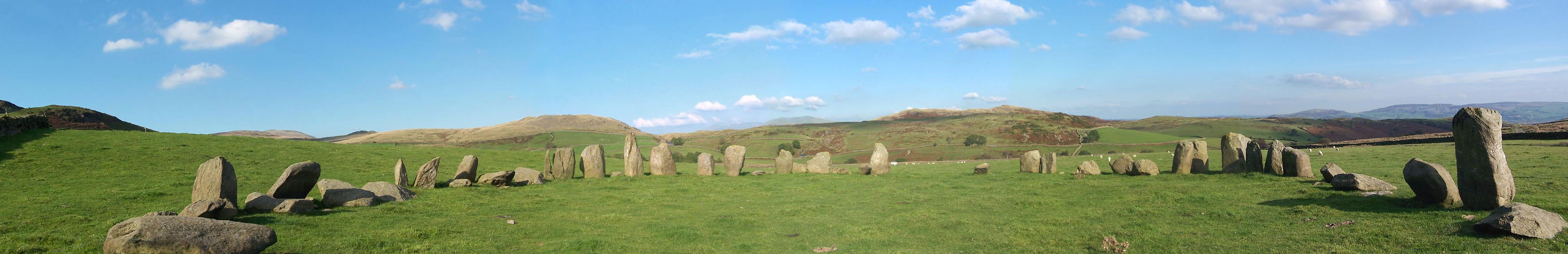
| Swinside Stone Circle, Swinside | ||
| Swinside Stone Circle | ||
| Sunenkirk | ||
| locality:- | Swinside | |
| civil parish:- | Millom Without (formerly Cumberland) | |
| county:- | Cumbria | |
| locality type:- | stone circle | |
| coordinates:- | SD17168817 | |
| 1Km square:- | SD1788 | |
| 10Km square:- | SD18 | |
| altitude:- | 722 feet | |
| altitude:- | 220m | |
| SummaryText:- | 51 stones in a circle diameter 28.7m. Local metamorphic slate called 'grey cobbles'. | |
|
|
||
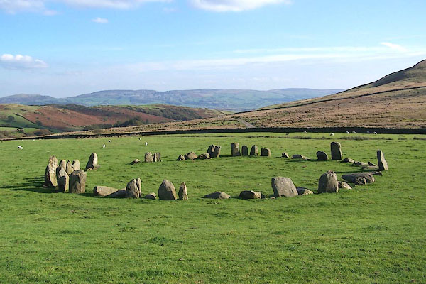 BOF46.jpg (taken 1.10.2007) 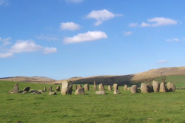 BOF45.jpg (taken 1.10.2007) |
||
|
|
||
| evidence:- | old map:- OS County Series (Cmd 86 14) placename:- Sunken Kirk |
|
| source data:- | Maps, County Series maps of Great Britain, scales 6 and 25
inches to 1 mile, published by the Ordnance Survey, Southampton,
Hampshire, from about 1863 to 1948. |
|
|
|
||
| evidence:- | old text:- Camden 1789 (Gough Additions) placename:- Sunken Kirk |
|
| source data:- | Book, Britannia, or A Chorographical Description of the Flourishing Kingdoms of England,
Scotland, and Ireland, by William Camden, 1586, translated from the 1607 Latin edition
by Richard Gough, published London, 1789. Page 179:- "..." "At Swineshead, a very high hill between Bow fell in this county and Broughton in Furness in Lancashire, four miles from the latter, is a druidical temple, which the country people call Sunken Kirk, i.e.a church sunk into the earth. It is nearly a circle of very large stones, pretty entire, only a few fallen, upon sloping ground in a swampy meadow. No situation could be more agreeable to the Druids than this; mountains almost encircle it, not a tree is to be seen in the neighbourhood, nor a house, except a shepherd's cot at the foot of a mountain surrounded by a few barren pastures." "At the entrance there are four large stones, two placed on each side at the distance of six feet. The largest on the left hand side is five feet six inches in height, and 10 feet in circumference. Through this you enter into a circular area, 29 yards by 30. This entrance is nearly south-east. On the north or right hand side is a huge stone of a conical form, in height nearly 9 feet. Opposite the entrance is another large stone, which has once been erect, but is now fallen within the area; its length is eight feet. To the left hand or south-west is one, in height seven feet, in circumference 11 feet nine inches. The altar probably stood in the middle, as there are some stones still to be seen, though sunk deep in the earth. The circle is nearly complete, except on the western side some stones are wanting. The largest stones are about thirty-one or two in number. The outward part of the circle upon the sloping ground is surrounded with a buttress or rude pavement of smaller stones raised about half a yard from the surface of the earth." "The situation and aspect of the druidical temple near Keswick, mentioned by Mr. Pennant in his tour, is in every respect similar to this, except the rectangular recess formed by 10 large stones, which is peculiar to that at Keswick; but, upon the whole, I think a preference will be given to this at Swinshead, as the stones in general appear much larger, and the circle more entire." "This monument of antiquity, when viewed within the circle, strikes you with astonishment how the massy stones could be placed in such regular order either by human strength or mechanical power." |
|
|
|
||
| evidence:- | old text:- Gents Mag |
|
| source data:- | Magazine, The Gentleman's Magazine or Monthly Intelligencer or
Historical Chronicle, published by Edward Cave under the
pseudonym Sylvanus Urban, and by other publishers, London,
monthly from 1731 to 1922. goto source goto sourceGentleman's Magazine 1843 part 2 p.362 "[in] the parish of Millum, in the same county, there did exist the remains of a Druidical temple, which the country people called sunken kirk, i.e. a church sunk into the earth. It is nearly a circle of very large stones, pretty entire, only a few fallen upon sloping ground in a swampy meadow. At the entrance there are four large stones, two on each side, at the distance of six feet. Through these you enter into a circular area, twenty-nine yards by thirty. The entrance is nearly south-east. It seems probable that the altar stood in the middle, as there are some stones still to be seen there, though sunk deep in the earth. ..." |
|
|
|
||
| evidence:- | old photograph:- Bell 1880s-1940s |
|
| source data:- | Photograph, b/w, house, Swinside Stone Circle, Millom Without, Cumberland, by Herbert
Bell, Ambleside, Westmorland, 1890s?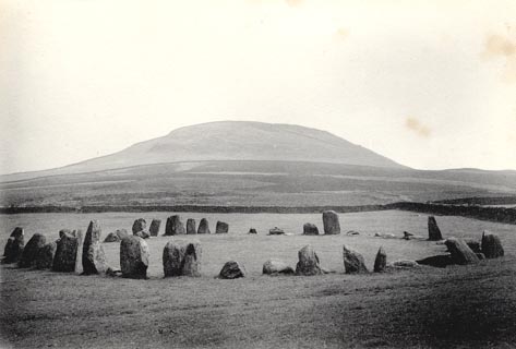 click to enlarge click to enlargeHB0312.jpg item:- Armitt Library : ALPS671 Image © see bottom of page |
|
|
|
||
| evidence:- | old photograph:- Bell 1880s-1940s |
|
| source data:- | Photograph, b/w, Swinside Stone Circle, Millom Without, Cumberland, by Herbert Bell,
Ambleside, Westmorland, 1890s?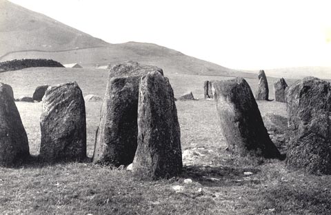 click to enlarge click to enlargeHB0308.jpg item:- Armitt Library : ALPS672 Image © see bottom of page |
|
|
|
||
 Click to enlarge BOF47.jpg (taken 1.10.2007) |
||
|
|
||
| hearsay:- |
Called Sunenkirk because the Devil made the stones, which were to be used to build
a church, sink into the ground each night. |
|
| Burl calls this:- |
||
| "... the loveliest of all the circles ..." |
||
| Waterhouse, John: 1985: Stone Circles of Cumbria: Phillimore and Co (Chichester, Sussex)::
ISBN 0 85033 566 3 Thom, A: 1967: Megalithic Sites in Britain: Oxford University Press (Oxford, Oxfordshire) Dymond, C W: 1902:: TWCAAS: vol.2: pp.53- Burl, H A W: 1976: Stone Circles of the British Isles: Yale University Press (United States) |
||
|
|
||
Lakes Guides menu.