 Old Cumbria Gazetteer
 |
 |
|
||||||||||||||||||||||||||||
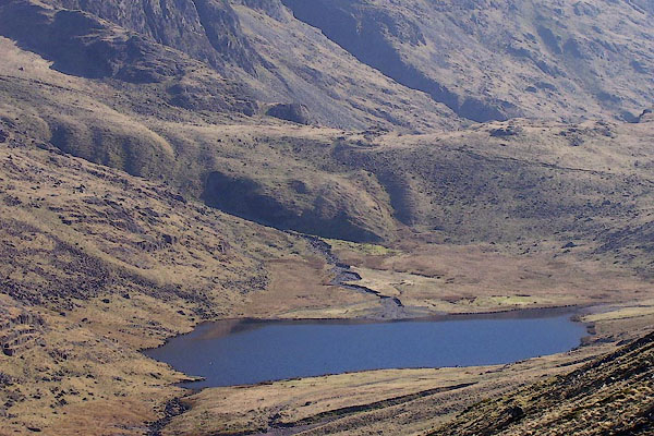
| Styhead Tarn, Borrowdale | ||||||||||||||||||||||||||||||
| runs into:- |  Styhead Gill Styhead Gill |
|||||||||||||||||||||||||||||
|
|
||||||||||||||||||||||||||||||
| Styhead Tarn | ||||||||||||||||||||||||||||||
| locality:- | Sty Head | |||||||||||||||||||||||||||||
| civil parish:- | Borrowdale (formerly Cumberland) | |||||||||||||||||||||||||||||
| county:- | Cumbria | |||||||||||||||||||||||||||||
| locality type:- | tarn | |||||||||||||||||||||||||||||
| coordinates:- | NY22170986 (etc) | |||||||||||||||||||||||||||||
| 1Km square:- | NY2209 | |||||||||||||||||||||||||||||
| 10Km square:- | NY20 | |||||||||||||||||||||||||||||
| altitude:- | 1430 feet | |||||||||||||||||||||||||||||
| altitude:- | 436m | |||||||||||||||||||||||||||||
|
|
||||||||||||||||||||||||||||||
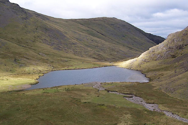 BRM73.jpg (taken 14.9.2009) 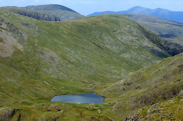 BPF45.jpg (taken 20.5.2008) |
||||||||||||||||||||||||||||||
|
|
||||||||||||||||||||||||||||||
| evidence:- | old map:- OS County Series (Cmd 74 8) placename:- Styhead Tarn |
|||||||||||||||||||||||||||||
| source data:- | Maps, County Series maps of Great Britain, scales 6 and 25
inches to 1 mile, published by the Ordnance Survey, Southampton,
Hampshire, from about 1863 to 1948. |
|||||||||||||||||||||||||||||
|
|
||||||||||||||||||||||||||||||
| evidence:- | old map:- Donald 1774 (Cmd) placename:- Sparkling Tarn |
|||||||||||||||||||||||||||||
| source data:- | Map, hand coloured engraving, 3x2 sheets, The County of Cumberland, scale about 1
inch to 1 mile, by Thomas Donald, engraved and published by Joseph Hodskinson, 29
Arundel Street, Strand, London, 1774.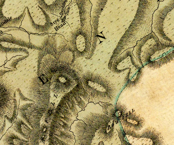 D4NY20NW.jpg "Sparkling Tarn" lake item:- Carlisle Library : Map 2 Image © Carlisle Library |
|||||||||||||||||||||||||||||
|
|
||||||||||||||||||||||||||||||
| evidence:- | old map:- West 1784 map placename:- Sparkling Tarn |
|||||||||||||||||||||||||||||
| source data:- | Map, hand coloured engraving, A Map of the Lakes in Cumberland,
Westmorland and Lancashire, scale about 3.5 miles to 1 inch,
engraved by Paas, 53 Holborn, London, about 1784. Ws02NY20.jpg item:- Armitt Library : A1221.1 Image © see bottom of page |
|||||||||||||||||||||||||||||
|
|
||||||||||||||||||||||||||||||
| evidence:- | old print:- Wilkinson 1810 (plate 43) placename:- Stye Head Tarn item:- fishing |
|||||||||||||||||||||||||||||
| source data:- | Print, uncoloured soft ground etching, Stye Head Tarn, with Aron, or Great End , above
Borrowdale, Cumberland, by Joseph Wilkinson, engraved by William Frederick Wells,
published by R Ackermann, Repository of Arts, 101 Strand, London, 1810.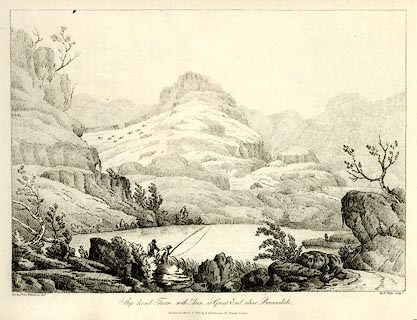 click to enlarge click to enlargeWKN143.jpg Plate 43 in Select Views in Cumberland, Westmoreland, and Lancashire. printed at bottom left, right, centre:- "The Revd. Jos: Wilkinson delt. / W. F. Wells Sculpt. / Stye-head Tarn, with Aron, or Great-End, above Borrowdale / Publish'd April 1. 1810. by R. Ackermann. 101. Strand. London." item:- Fell and Rock Climbing Club : MN4.43 Image © see bottom of page |
|||||||||||||||||||||||||||||
|
|
||||||||||||||||||||||||||||||
| evidence:- | old print:- Green 1815 placename:- Sty Head Tarn |
|||||||||||||||||||||||||||||
| source data:- | Print, coloured aquatint, Sty Head Tarn, Borrowdale, Cumberland, by William Green,
Ambleside, Westmorland, 1815.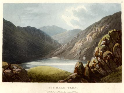 click to enlarge click to enlargeGN0544.jpg Plate 48 in Lake Scenery. printed at upper right:- "48" printed at bottom:- "STY HEAD TARN. / Published at Ambleside, June 1, 1815, by Wm. Green." item:- Armitt Library : A6646.44 Image © see bottom of page |
|||||||||||||||||||||||||||||
|
|
||||||||||||||||||||||||||||||
| evidence:- | old map:- Otley 1818 |
|||||||||||||||||||||||||||||
| source data:- | Map, uncoloured engraving, The District of the Lakes,
Cumberland, Westmorland, and Lancashire, scale about 4 miles to
1 inch, by Jonathan Otley, 1818, engraved by J and G Menzies,
Edinburgh, Scotland, published by Jonathan Otley, Keswick,
Cumberland, et al, 1833.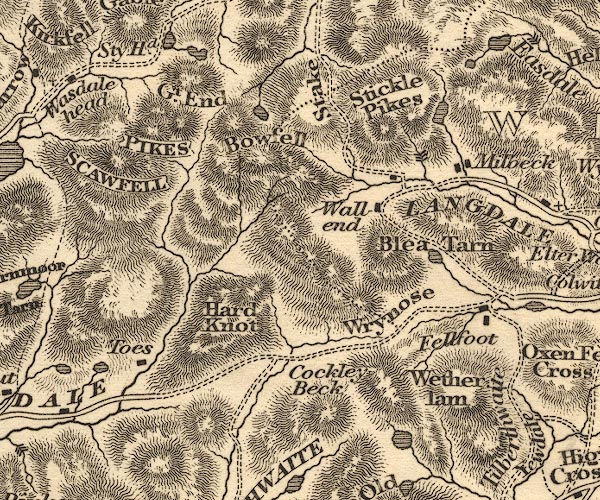 OT02NY20.jpg Drawn at:- "Sty Hd." item:- JandMN : 48.1 Image © see bottom of page |
|||||||||||||||||||||||||||||
|
|
||||||||||||||||||||||||||||||
| evidence:- | old print:- Fielding and Walton 1821 (plate 27) placename:- Sty Head Tarn |
|||||||||||||||||||||||||||||
| source data:- | Print, coloured aquatint, Sty Head Tarn, Top of Sty Head, Borrowdale, Cumberland,
drawn by Theodore H A Fielding, published by R Ackermann, 101 Strand, London, 1821.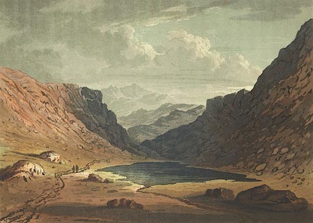 click to enlarge click to enlargeFW0127.jpg Tipped in opposite p.193 in A Picturesque Tour of the English Lakes. item:- Dove Cottage : 1993.R566.27 Image © see bottom of page |
|||||||||||||||||||||||||||||
|
|
||||||||||||||||||||||||||||||
| evidence:- | descriptive text:- Otley 1823 (5th edn 1834) placename:- Styhead Tarn placename:- Sparkling Tarn item:- fishing |
|||||||||||||||||||||||||||||
| source data:- | Guide book, A Concise Description of the English Lakes, the
mountains in their vicinity, and the roads by which they may be
visited, with remarks on the mineralogy and geology of the
district, by Jonathan Otley, published by the author, Keswick,
Cumberland now Cumbria, by J Richardson, London, and by Arthur
Foster, Kirkby Lonsdale, Cumbria, 1823; published 1823-49,
latterly as the Descriptive Guide to the English Lakes. goto source Page 37:- "... Sty-head Tarn, in some maps called Sparkling Tarn, lies about three quarters of a mile below the last, near the road to Wasdale. The water, which it receives from Sprinkling Tarn, seems to have been deprived of its nutritive qualities; as its fish are of a very inferior kind. The stream running from thence towards Seathwaite, has some fine frothy breaks, and one grand waterfall, before it reaches the bottom of [the vale.]" |
|||||||||||||||||||||||||||||
|
|
||||||||||||||||||||||||||||||
| evidence:- | old map:- Ford 1839 map placename:- Sparkling Tarn |
|||||||||||||||||||||||||||||
| source data:- | Map, uncoloured engraving, Map of the Lake District of
Cumberland, Westmoreland and Lancashire, scale about 3.5 miles
to 1 inch, published by Charles Thurnam, Carlisle, and by R
Groombridge, 5 Paternoster Row, London, 3rd edn 1843.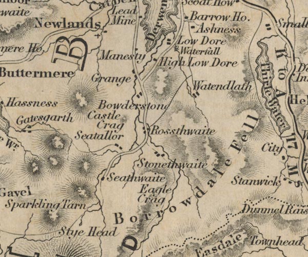 FD02NY21.jpg "Sparkling Tarn" Outline? item:- JandMN : 100.1 Image © see bottom of page |
|||||||||||||||||||||||||||||
|
|
||||||||||||||||||||||||||||||
| evidence:- | old text:- Miller 1847 placename:- Stye Head Tarn item:- rain gauge; rainfall |
|||||||||||||||||||||||||||||
| source data:- | Book, Report on the Fall of Rain in the Lake Districts of
Cumberland and Westmoreland in 1846, by John Fletcher Miller,
printed by G Irwin, Lowther Street, Whitehaven, Cumberland, 1847. goto source Page 4:- "Note. The Lake district Gauges are five inches in diameter; they are all of the same construction, and are elevated about eighteen inches above the surface. The funnel rims are of stout sheet brass, so that the apertures cannot readily lose their circular form. The Metres were all made by Bate of the Poultry, London. - The Rain is read off daily at 9 A.M." "..." goto sourcePage 8:- 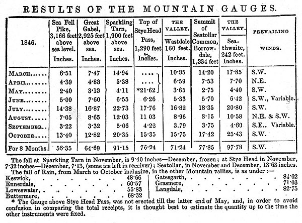 MI02Tab3.jpg goto sourcePage 9:- "REMARKS ON MOUNTAIN GAUGES." "The Mountain Gauges are on pretty much the same construction as those in the vallies, but the receivers are much more capacious, being calculated to hold nearly 80 inches of Rain." "..." "... The Gauge near Stye Head Tarn, is on the Shoulder of Great Gabel, at the eastern extremity of the vale: ..." "... the whole of the instruments are freely exposed to the action of wind and rain, from almost every point of the compass." "..."
|
|||||||||||||||||||||||||||||
|
|
||||||||||||||||||||||||||||||
| evidence:- | old map:- Garnett 1850s-60s H placename:- Styhead Tarn |
|||||||||||||||||||||||||||||
| source data:- | Map of the English Lakes, in Cumberland, Westmorland and
Lancashire, scale about 3.5 miles to 1 inch, published by John
Garnett, Windermere, Westmorland, 1850s-60s.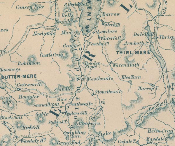 GAR2NY21.jpg "Styhead T." outline with shore form lines, lake or tarn item:- JandMN : 82.1 Image © see bottom of page |
|||||||||||||||||||||||||||||
|
|
||||||||||||||||||||||||||||||
| evidence:- | old text:- Martineau 1855 |
|||||||||||||||||||||||||||||
| source data:- | Guide book, A Complete Guide to the English Lakes, by Harriet
Martineau, published by John Garnett, Windermere, Westmorland,
and by Whittaker and Co, London, 1855; published 1855-76. goto source Page 152:- "... the little clear rippling lake, where the mountaineer throws himself down to rest on the bank, when heated by the ascent from the vales. He has found" goto sourcePage 153:- "everything sunny and dry, perhaps; but here he sees, by the minute diamond drops resting thick on the grass, that a cloud has lately stooped from its course, and refreshed the verdure in this retreat. It looks very tempting - this bright sheet of water; but no creature now comes to drink, unless a sheep may have strayed far from the flock, and in its terror may yet venture to stoop to the water, with many a start and interval of listening, till, at the faint sound of the distant sheep dog, it bounds away. The solitude is almost equally impressive whether the traveller comes up from the one dale or the other; ... The rill from Sprinkling Tarn is close by, and it leads to this Sty Head Tarn, where the boars used to come to drink. ..." |
|||||||||||||||||||||||||||||
|
|
||||||||||||||||||||||||||||||
| evidence:- | old photograph:- Bell 1880s-1940s |
|||||||||||||||||||||||||||||
| source data:- | Photograph, sepia, Sty Head, Nether Wasdale and Borrowdale, Cumberland, by Herbert
Bell, Ambleside, Westmorland, 1890s?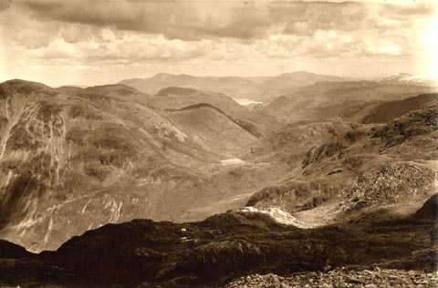 click to enlarge click to enlargeHB0344.jpg Looking across Styhead Tarn down to Derwent Water. item:- Armitt Library : ALPS710 Image © see bottom of page |
|||||||||||||||||||||||||||||
|
|
||||||||||||||||||||||||||||||
| evidence:- | outline view:- Jenkinson 1875 placename:- Sty Head Tarn |
|||||||||||||||||||||||||||||
| source data:- | Print, lithograph, outline view, Panoramic Sketches from Scawfell Pike, Cumberland,
by Edwin A Pettitt, London, published by Edward Stanford, 55 Charing Cross, London,
1875. click to enlarge click to enlargeJk01E3.jpg "... Sty Head Tarn ..." item:- JandMN : 28.9 Image © see bottom of page |
|||||||||||||||||||||||||||||
|
|
||||||||||||||||||||||||||||||
| evidence:- | old print:- Prior 1865 placename:- Sty Head Tarn |
|||||||||||||||||||||||||||||
| source data:- | Print, uncoloured engraving, Sty Head Tarn, Scafell Pike, and Scafell, in Borrowdale
and in Eskdale, Cumberland, published by John Garnett, Windermere, Westmorland, and
by Simpkin, Marshall and Co, London, 1865.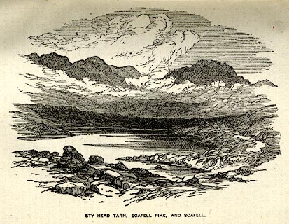 click to enlarge click to enlargePI0106.jpg Included on page 39 of the guide book, Ascents and Passes in the Lake District of England, by Herman Prior. printed at bottom:- "STY HEAD TARN, SCAFELL PIKE, AND SCAFELL." item:- JandMN : 235.8 Image © see bottom of page |
|||||||||||||||||||||||||||||
|
|
||||||||||||||||||||||||||||||
| evidence:- | outline view:- Tattersall 1836 (version 1869) placename:- Stye Head Tarn |
|||||||||||||||||||||||||||||
| source data:- | Print, hand coloured, Stye Head Tarn, Cumberland, drawn by George Tattersall, 1836,
engraved by W F Topham, published by T J Allman, 463 Oxford Street, London, 1869.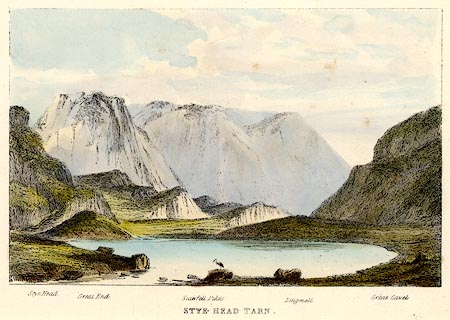 click to enlarge click to enlargeTAT213.jpg Included in The Lakes of England, by W F Topham. printed at bottom:- "STYE HEAD TARN." printed at bottom:- "Stye Head. / Great End. / Scawfell Pike. / Lingmell. / Great Gavel." item:- Armitt Library : A1067.13 Image © see bottom of page |
|||||||||||||||||||||||||||||
|
|
||||||||||||||||||||||||||||||
| evidence:- | outline view:- Tattersall 1836 placename:- Stye Head Tarn item:- heron |
|||||||||||||||||||||||||||||
| source data:- | Print, engraving, Stye Head Tarn, Borrowdale, Cumberland, drawn by George Tattersall,
engraved by W F Topham, published by Sherwood and Co, Paternoster Row, London, about
1836.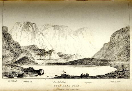 click to enlarge click to enlargeTAT131.jpg The print is captioned with mountain names and acts as an outline view. Tipped in opposite p.78 of The Lakes of England, by George Tattersall. printed at bottom:- "STYE HEAD TARN. / London Pubd. April 15th. 1836, by Sherwood &Co." printed at bottom left to right:- "Stye Head. / Great End. / Scawfell Pikes. / Lingmell. / Great Gavel." item:- Armitt Library : A1204.32 Image © see bottom of page |
|||||||||||||||||||||||||||||
|
|
||||||||||||||||||||||||||||||
| evidence:- | old print:- Rose 1832-35 placename:- Sty Head Tarn |
|||||||||||||||||||||||||||||
| source data:- | Print, engraving, Sty Head Tarn, Cumberland, by Thomas Allom, engraved by A le Petit,
1833.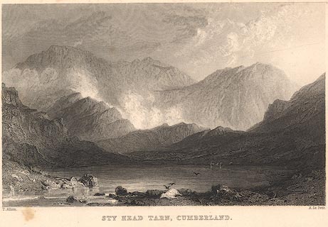 click to enlarge click to enlargeR271.jpg "Sty Head Tarn, Cumberland" item:- JandMN : 96.22 Image © see bottom of page |
|||||||||||||||||||||||||||||
|
|
||||||||||||||||||||||||||||||
 BNM90.jpg (taken 4.4.2007) 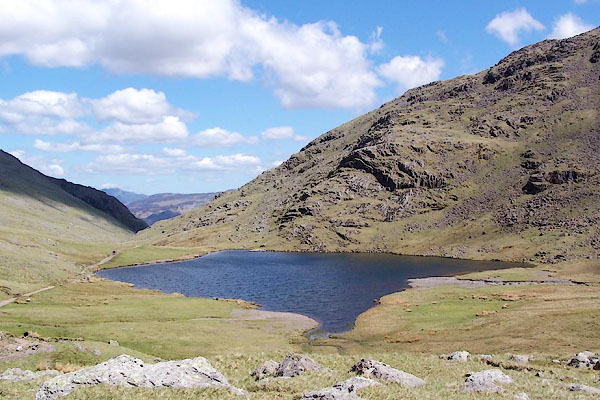 BQO13.jpg (taken 12.5.2009) |
||||||||||||||||||||||||||||||
|
|
||||||||||||||||||||||||||||||
Lakes Guides menu.