 Old Cumbria Gazetteer
 |
 |
|
| St Bees Head, St Bees | ||
| St Bees Head | ||
| Bega's Head | ||
| civil parish:- | St Bees (formerly Cumberland) | |
| county:- | Cumbria | |
| locality type:- | locality | |
| locality type:- | headland | |
| locality type:- | geological site | |
| locality type:- | bird | |
| coordinates:- | NX95211337 (etc) | |
| 1Km square:- | NX9513 | |
| 10Km square:- | NX91 | |
|
|
||
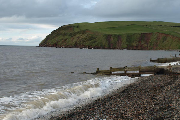 BXQ39.jpg South Head, St Bees. (taken 16.11.2012) 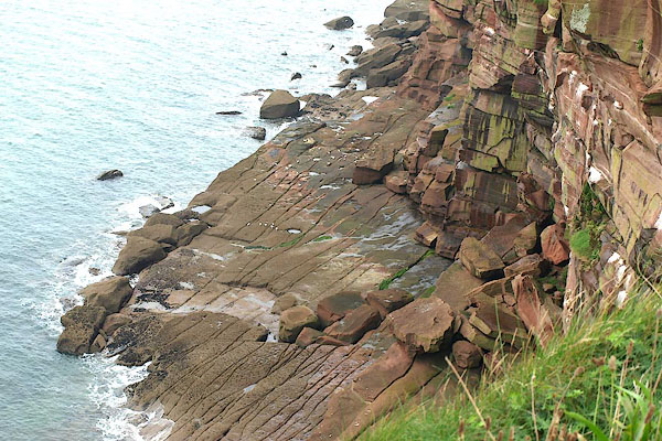 BPQ69.jpg Sea and rocks; bedding and jointing. (taken 29.8.2008) |
||
|
|
||
| evidence:- | old map:- OS County Series (Cmd 67 13) placename:- St Bees Head |
|
| source data:- | Maps, County Series maps of Great Britain, scales 6 and 25
inches to 1 mile, published by the Ordnance Survey, Southampton,
Hampshire, from about 1863 to 1948. |
|
|
|
||
| evidence:- | old map:- Saxton 1579 placename:- St Bees Head |
|
| source data:- | Map, hand coloured engraving, Westmorlandiae et Cumberlandiae Comitatus ie Westmorland
and Cumberland, scale about 5 miles to 1 inch, by Christopher Saxton, London, engraved
by Augustinus Ryther, 1576, published 1579-1645.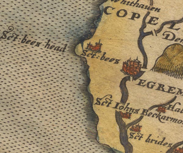 Sax9NX91.jpg "Sct: bees head" Headland. item:- private collection : 2 Image © see bottom of page |
|
|
|
||
| evidence:- | old map:- Speed 1611 (Cmd) placename:- St Bees Head |
|
| source data:- | Map, hand coloured engraving, Cumberland and the Ancient Citie
Carlile Described, scale about 4 miles to 1 inch, by John Speed,
1610, published by J Sudbury and George Humble, Popes Head
Alley, London, 1611-12.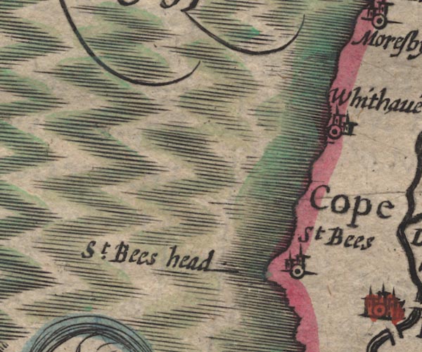 SP11NX91.jpg "St. Bees head" headland item:- private collection : 16 Image © see bottom of page |
|
|
|
||
| evidence:- | old map:- Jansson 1646 placename:- St Bees Head |
|
| source data:- | Map, hand coloured engraving, Cumbria and Westmoria, ie
Cumberland and Westmorland, scale about 3.5 miles to 1 inch, by
John Jansson, Amsterdam, Netherlands, 1646.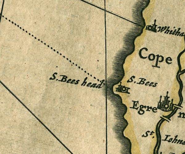 JAN3NX91.jpg "S. Bees head" Labelling the headland. item:- JandMN : 88 Image © see bottom of page |
|
|
|
||
| evidence:- | old map:- Seller 1694 (Cmd) placename:- St Bees Head |
|
| source data:- | Map, uncoloured engraving, Cumberland, scale about 12 miles to 1
inch, by John Seller, 1694. click to enlarge click to enlargeSEL9.jpg "St. Bees head" headland item:- Dove Cottage : 2007.38.89 Image © see bottom of page |
|
|
|
||
| evidence:- | old map:- Morden 1695 (EW) placename:- St Bees Head |
|
| source data:- | Map, hand coloured engraving, England, including Wales, scale
about 27 miles to 1 inch, by Robert Morden, published by Abel
Swale Awnsham and John Churchil, London, about 1695. click to enlarge click to enlargeMRD3Cm.jpg "St. Bees head" headland item:- JandMN : 339 Image © see bottom of page |
|
|
|
||
| evidence:- | old map:- Morden 1695 (Cmd) placename:- St Bees Head |
|
| source data:- | Map, uncoloured engraving, Cumberland, scale about 4 miles to 1
inch, by Robert Morden, 1695, published by Abel Swale, the
Unicorn, St Paul's Churchyard, Awnsham, and John Churchill, the
Black Swan, Paternoster Row, London, 1695-1715.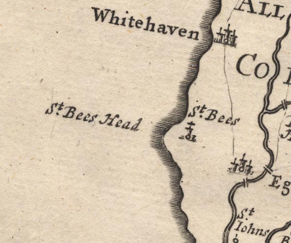 MD12NX91.jpg "St. Bees Head" Headland. item:- JandMN : 90 Image © see bottom of page |
|
|
|
||
| evidence:- | descriptive text:- Defoe 1724-26 placename:- item:- snow; weather; bull |
|
| source data:- | Tour through England and Wales, by Daniel Defoe, published in
parts, London, 1724-26. "The cape or head land of St. Bees, still preserves its name; as for the lady, like that of St. Tabbs beyond Berwick, the story is become fabulous, viz. about her procuring, by her prayers, a deep snow on Midsummer Day, her taming a wild bull that did great damage in the country; these, and the like tales, I leave where I found them, (viz.) among the rubbish of the old women and the Romish priests." |
|
|
|
||
| evidence:- | old map:- Badeslade 1742 placename:- St Bees Head |
|
| source data:- | Map, uncoloured engraving, A Map of Cumberland North from
London, scale about 11 miles to 1 inch, with descriptive text,
by Thomas Badeslade, London, engraved and published by William
Henry Toms, Union Court, Holborn, London, 1742. click to enlarge click to enlargeBD10.jpg "St. Bees head" headland item:- JandMN : 115 Image © see bottom of page |
|
|
|
||
| evidence:- | old map:- Bowen and Kitchin 1760 placename:- St Bees Head |
|
| source data:- | Map, hand coloured engraving, A New Map of the Counties of
Cumberland and Westmoreland Divided into their Respective Wards,
scale about 4 miles to 1 inch, by Emanuel Bowen and Thomas
Kitchin et al, published by T Bowles, Robert Sayer, and John
Bowles, London, 1760.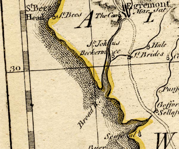 BO18NX90.jpg "St. Bees Head" headland item:- Armitt Library : 2008.14.10 Image © see bottom of page |
|
|
|
||
| evidence:- | old map:- Donald 1774 (Cmd) placename:- St Bees Heads |
|
| source data:- | Map, hand coloured engraving, 3x2 sheets, The County of Cumberland, scale about 1
inch to 1 mile, by Thomas Donald, engraved and published by Joseph Hodskinson, 29
Arundel Street, Strand, London, 1774.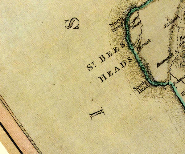 D4NX91SW.jpg "ST. BEES HEADS" headland item:- Carlisle Library : Map 2 Image © Carlisle Library |
|
|
|
||
| evidence:- | old text:- Mackenzie 1776 placename:- St Bee's Head |
|
| source data:- | Charts, and sailing directions, Nautical Descriptions of the
West Coast of Great Britain, Bristol Channel to Cape Wrath, by
Murdoch Mackenzie, published London, 1776. goto source goto sourcePage 18:- "... ..." "A Description of the Tides, Rocks, Shoals, Channels, Anchoring-places, and Harbours, between PIEL-OF-FOUDRAY and St BEE's HEAD." "CHART XI." "TIDES / Tides between PIEL-OF-FOUDRAY and St. BEE's HEAD." "Time of High-water. / Between Piel-of-Foudray, and St. Bee's Head in Cumberland, it is high-water on the shore at eleven, on full and change days." "Rise of the Tides. / Spring-tide rises twenty feet perpendicular; neap-tide six or seven." "..." goto sourcePage 23:- "... ..." "... There is a light kept on St. Bee's Head to shew vessels into Solway Firth at night: ..." |
|
|
|
||
| evidence:- | old text:- Camden 1789 item:- placename, St Bees |
|
| source data:- | Book, Britannia, or A Chorographical Description of the Flourishing Kingdoms of England,
Scotland, and Ireland, by William Camden, 1586, translated from the 1607 Latin edition
by Richard Gough, published London, 1789. goto source Page 169:- "..." "The shore now advancing gradually to the west forms a little point, commonly called St. Bees for St. Bega's. This Bega was a devout and holy virgin of Ireland, who passed her life in solitude here, and to whose piety many miracles are ascribed, as taming a wild bull, and by her prayers covering with a great depth of snow the vallies and hill tops in the middle of summer. ..." |
|
|
|
||
| evidence:- | old text:- Camden 1789 (Gough Additions) placename:- Bamhead placename:- Bees Head |
|
| source data:- | Book, Britannia, or A Chorographical Description of the Flourishing Kingdoms of England,
Scotland, and Ireland, by William Camden, 1586, translated from the 1607 Latin edition
by Richard Gough, published London, 1789. goto source Page 180:- "..." "The great cliff called Bamhead or Bees head abounds with plenty of sea fowl." |
|
|
|
||
| evidence:- | old map:- Cooke 1802 placename:- St Bees Heads |
|
| source data:- | Map, The Lakes, Westmorland and Cumberland, scale about 8.5
miles to 1 inch, engravedby Neele and Son, published by
Sherwood, Jones and Co, Paternoster Road, London, 1824. click to enlarge click to enlargeGRA1Lk.jpg "St. Bees Heads" headland item:- Hampshire Museums : FA2000.62.5 Image © see bottom of page |
|
|
|
||
| evidence:- | old map:- Cooper 1808 placename:- St Bees Head |
|
| source data:- | Map, uncoloured engraving, Cumberland, scale about 10.5 miles to
1 inch, drawn and engraved by Cooper, published by R Phillips,
Bridge Street, Blackfriars, London, 1808. click to enlarge click to enlargeCOP3.jpg "St. Bees Head" headland item:- JandMN : 86 Image © see bottom of page |
|
|
|
||
| evidence:- | old map:- Otley 1818 |
|
| source data:- | Map, uncoloured engraving, The District of the Lakes,
Cumberland, Westmorland, and Lancashire, scale about 4 miles to
1 inch, by Jonathan Otley, 1818, engraved by J and G Menzies,
Edinburgh, Scotland, published by Jonathan Otley, Keswick,
Cumberland, et al, 1833.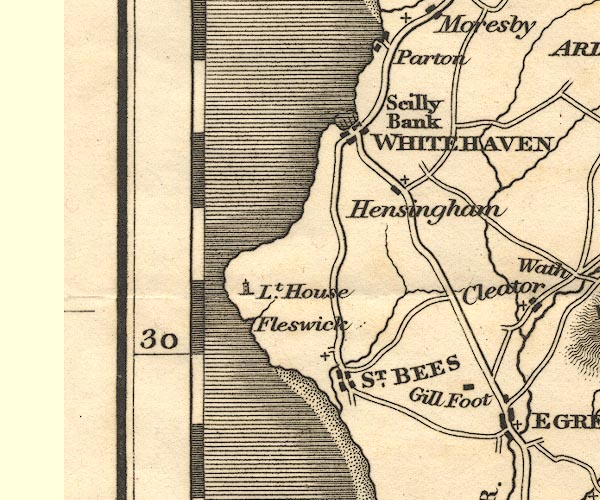 OT02NX91.jpg item:- JandMN : 48.1 Image © see bottom of page |
|
|
|
||
| evidence:- | old text:- Gents Mag placename:- Preston Isle |
|
| source data:- | Magazine, The Gentleman's Magazine or Monthly Intelligencer or
Historical Chronicle, published by Edward Cave under the
pseudonym Sylvanus Urban, and by other publishers, London,
monthly from 1731 to 1922. goto source Gentleman's Magazine 1831 part 1 p.300 "Mr. URBAN," "... From Saint Bees to Whitehaven, a distance of about four miles, there is a narrow vale entirely separating the high lands on the coast from the interior. From the general appearance of the soil, and the discovery of an anchor some years since, about the centre of this vale, it is probable that it was formerly an arm of the sea. ... In fact, the hilly ground supposed to be thus formerly isolated, is distinguished in ancient deeds by the appelation of Preston Isle. ..." |
|
|
|
||
| evidence:- | old map:- Ford 1839 map placename:- St Bees Head |
|
| source data:- | Map, uncoloured engraving, Map of the Lake District of
Cumberland, Westmoreland and Lancashire, scale about 3.5 miles
to 1 inch, published by Charles Thurnam, Carlisle, and by R
Groombridge, 5 Paternoster Row, London, 3rd edn 1843.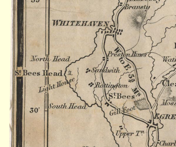 FD02NX91.jpg "St. Bees Head" Headland. item:- JandMN : 100.1 Image © see bottom of page |
|
|
|
||
| evidence:- | probably old drawing:- Aspland 1840s-60s |
|
| source data:- | Drawing, ink, coast at St Bees, Cumberland, by Theophilus Lindsey Aspland, 1868-69.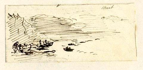 click to enlarge click to enlargeAS0627.jpg "[ ] / St Bees" item:- Armitt Library : 2008.61.27 Image © see bottom of page |
|
|
|
||
| evidence:- | old map:- Hydrographic Office 1850s onwards placename:- St Bees Head |
|
| source data:- | Chart, uncoloured engraving, England West Coast sheet XI,
Fleetwood to the Firth of Solway, scale about 2.5 miles to 1
inch, by H Denham and G Williams, 1846, engraved by J and C
Walker, published by the Hydrographic Office, 1850 corrected to
1863 coast view on Admiralty chart 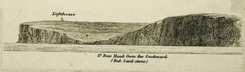 click to enlarge click to enlargeHY01P5.jpg "St. Bees Head from the Southward (Red Sand-stone)" item:- Carlisle Library : Map 93 Image © Carlisle Library |
|
|
|
||
| evidence:- | old map:- Garnett 1850s-60s H placename:- St Bees Head |
|
| source data:- | Map of the English Lakes, in Cumberland, Westmorland and
Lancashire, scale about 3.5 miles to 1 inch, published by John
Garnett, Windermere, Westmorland, 1850s-60s.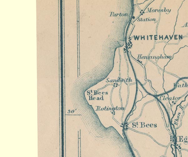 GAR2NX91.jpg "St. Bees Head" headland item:- JandMN : 82.1 Image © see bottom of page |
|
|
|
||
| evidence:- | text:- Mason 1907 (edn 1930) |
|
| source data:- | Text book, The Ambleside Geography Books bk.III, The Counties of
England, by Charlotte M Mason, published by Kegan Paul, Trench,
Trubner and Co, Broadway House, 68-74 Carter Lane, and the
Parents' Educational Union Office, 26 Victoria Street, London,
edn 1930. MSN1P025.txt Page 25:- "..." "A little south of Whitehaven is the red headland of St. Bees, the finest on the coast, where the cliffs are washed by the stormy sea, which has strewn the beach with huge rock boulders. ..." |
|
|
|
||
| evidence:- | old map:- Postlethwaite 1877 (3rd edn 1913) placename:- St Bees Head |
|
| source data:- | Map, uncoloured engraving, Map of the Lake District Mining Field, Westmorland, Cumberland,
Lancashire, scale about 5 miles to 1 inch, by John Postlethwaite, published by W H
Moss and Sons, 13 Lowther Street, Whitehaven, Cumberland, 1877 edn 1913.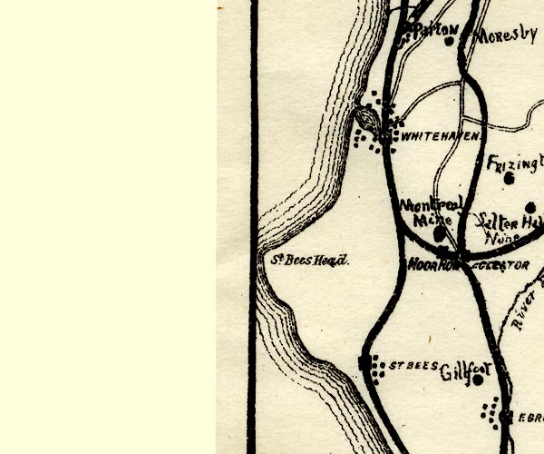 PST2NX91.jpg "St. Bees Head." headland item:- JandMN : 162.2 Image © see bottom of page |
|
|
|
||
| evidence:- | old text:- Admiralty 1933 placename:- St Bees Head |
|
| source data:- | goto source Page 385:- "..." "Coast. - St. Bees head (see view on chart 1346 or chart 1826), remarked on at page 389, is a perpendicular cliff, 310 feet (94m5) high, situated about 12 3/4 miles north-westward of Drigg point; the background of the intervening coast is mountainous. ..." goto sourcePage 389:- "... St. Bees head (Lat. 54~ 31' N., Long. 3~ 38' W.), the southern point of the entrance to the Firth of Solway, is a perpendicular cliff of red sandstone, about 310 feet (102m4) high, with a flat summit within." "..." "A look-out for life-saving purposes is kept from St. Bees head." |
|
|
|
||
| evidence:- | old print:- Robertson 1911 placename:- St Bees Head |
|
| source data:- | Print, lithograph? Whitehaven Pier and St Bees Head, from Moresby, from a watercolour
by Arthur Tucker, published by Chatto and Windus, London, 1911.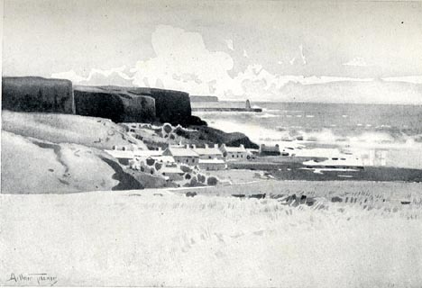 click to enlarge click to enlargeRSN111.jpg Tipped in opposite p.36 of Wordsworthshire by Eric Robertson. printed at bottom:- "WHITEHAVEN PIER AND ST. BEE'S HEAD, FROM MORESBY" signed at painting lower left:- "Arthur Tucker" item:- JandMN : 197.11 Image © see bottom of page |
|
|
|
||
| evidence:- | old print:- placename:- St Bees Head |
|
| source data:- | Print, uncoloured engraving, Whitehaven, Cumberland, drawn by W H Bartlett, engraved
by J C Redaway, published 1840s.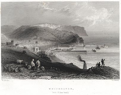 click to enlarge click to enlargePR0077.jpg Probably from Findens Views of the Ports, Harbours, Coast Scenery, and Watering Places of Great Britain, as continued by W H Bartlett. printed at bottom left, right, centre:- "W. H. Bartlett. / J. C. Redaway. / WHITEHAVEN, / (with St. Bees-head.)" item:- Dove Cottage : 2008.107.77 Image © see bottom of page |
|
|
|
||
| evidence:- | old drawing:- Smith 1746 B placename:- Bees Head |
|
| source data:- | Drawing, pencil and ink, A View of Bees Head, in a Survey of the Coast of Cumberland,
by George Smith, 1746.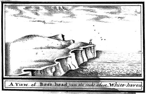 click to enlarge click to enlargeSM2102.jpg ms at bottom:- "A View of Bees-head, from the rocks above White-haven." item:- Carlisle Library : 5.2 Image © Carlisle Library |
|
|
|
||
 flowers flowers |
||
|
|
||
 BPQ61.jpg Sea and rocks. (taken 29.8.2008) 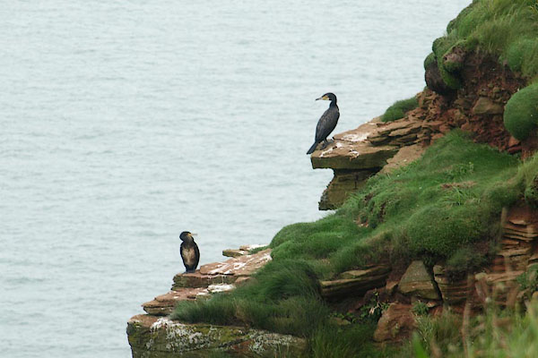 BPQ62.jpg Cormorant and young, Phalacrocorax carbo. (taken 29.8.2008) 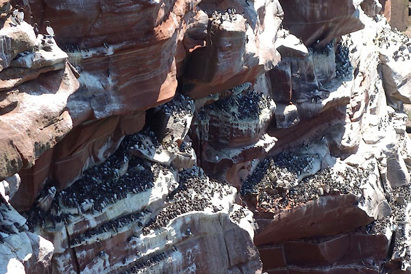 CDL31.jpg Guillemots, (taken 23.6.2015) 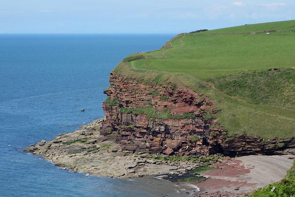 CDL19.jpg (taken 23.6.2015) |
||
|
|
||
| hearsay:- |
The beacons of west Cumberland were on: Black Combe, Boothill, Moota Hill, Muncaster
Fell, Skiddaw, St Bees Head, and Workington Hill. (Questionable information.) |
|
|
|
||
| notes:- |
From a distance the whole mass of hill, from St Bees to south of Kells, is St Bees
Head - sensibly labelled 'St Bees Heads' on some maps. For convenience of plotting
this record is located at the trig point inland and about the middle of the hill. |
|
|
|
||
Lakes Guides menu.