 Old Cumbria Gazetteer
 |
 |
|
|
| Solway Junction Railway | |||
| civil parish:- | Aspatria (formerly Cumberland) | ||
| civil parish:- | Bromfield (formerly Cumberland) | ||
| civil parish:- | Dundraw (formerly Cumberland) | ||
| civil parish:- | Holme Abbey (formerly Cumberland) | ||
| civil parish:- | Holme East Waver (formerly Cumberland) | ||
| civil parish:- | Kirkbride (formerly Cumberland) | ||
| civil parish:- | Bowness (formerly Cumberland) | ||
| county:- | Cumbria | ||
| locality type:- | railway | ||
| country:- | Scotland | ||
| locality type:- | railway | ||
| SummaryText:- | from Brayton on the Maryport and Carlisle Railway, to Abbey Town; then along the Carlisle and Silloth Bay Railway to Kirkbride; then Whitrigg, Bowness, Cumberland; across the Solway Firth; to Annan and northward, Scotland. | ||
| references:- | 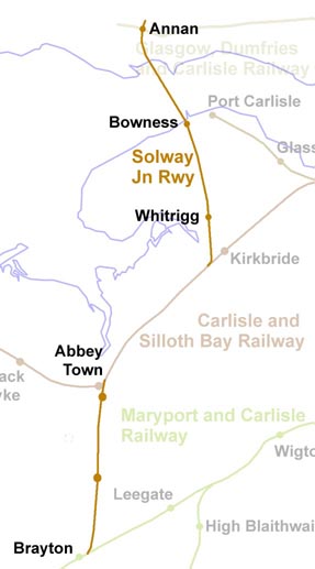 RWY022.jpg |
||
|
|
|||
 BLW39.jpg (taken 18.4.2006) |
|||
|
|
|||
| evidence:- | old map:- Garnett 1850s-60s H |
||
| source data:- | Map of the English Lakes, in Cumberland, Westmorland and
Lancashire, scale about 3.5 miles to 1 inch, published by John
Garnett, Windermere, Westmorland, 1850s-60s. GAR2NY26.jpg triple line, light bold light, railway  GAR2NY15.jpg 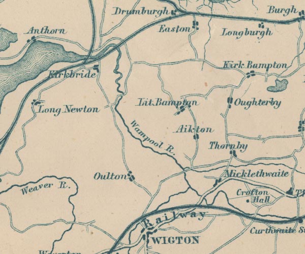 GAR2NY25.jpg 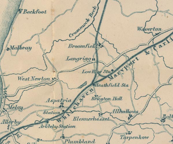 GAR2NY14.jpg item:- JandMN : 82.1 Image © see bottom of page |
||
|
|
|||
| hearsay:- |
20½miles. Worked by the Caledonian Railway from the start. |
||
|
|
|||
| person:- | railway company : Solway Junction Railway |
||
| date:- | 1864 to 1895 |
||
|
|
|||
| person:- | railway company : Caledonian Railway; CR |
||
| date:- | 1895 to 1921 |
||
|
|
|||
| goes through:- |  Kirkbride Junction, Holme East Waver Kirkbride Junction, Holme East Waver[Whitrigg Station, Bowness] signal box, Bowness Bowness Station, Bowness railway bridge, Bowness Solway Viaduct, Bowness Shawhill Junction, Scotland Annan Station, Scotland30.6.1864: authorized - 1869 - 1870: opened 1.9.1921: closed - |
||
|
|
|||
| goes through:- | Brayton Junction, Brayton engine shed, Brayton railway bridge, Langrigg railway bridge, Bromfield Bromfield Station, Bromfield railway bridge, Bromfield (2) Abbeyholme Station, Holme Abbey Abbey Junction, Holme Abbey 30.6.1864: authorized - 1869 - 1870: opened 1.9.1921: closed - |
||
|
|
|||
Lakes Guides menu.