 Old Cumbria Gazetteer
 |
 |
|
| Skelsmergh Hall Farm, Skelsmergh | ||
| Skelsmergh Hall Farm | ||
| Skelsmergh Hall | ||
| civil parish:- | Skelsmergh (formerly Westmorland) | |
| county:- | Cumbria | |
| locality type:- | buildings | |
| coordinates:- | SD53179591 | |
| 1Km square:- | SD5395 | |
| 10Km square:- | SD59 | |
|
|
||
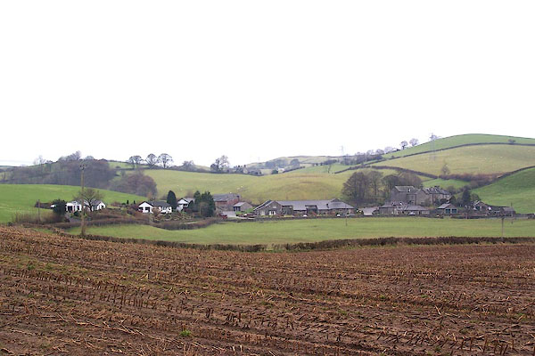 BLL20.jpg Skelsmergh Hall Farm and the Kiln Crofts development. (taken 9.12.2005) |
||
|
|
||
| evidence:- | old map:- OS County Series (Wmd 34 13) placename:- Skelsmergh Hall |
|
| source data:- | Maps, County Series maps of Great Britain, scales 6 and 25
inches to 1 mile, published by the Ordnance Survey, Southampton,
Hampshire, from about 1863 to 1948. |
|
|
|
||
| evidence:- | old map:- Saxton 1579 |
|
| source data:- | Map, hand coloured engraving, Westmorlandiae et Cumberlandiae Comitatus ie Westmorland
and Cumberland, scale about 5 miles to 1 inch, by Christopher Saxton, London, engraved
by Augustinus Ryther, 1576, published 1579-1645.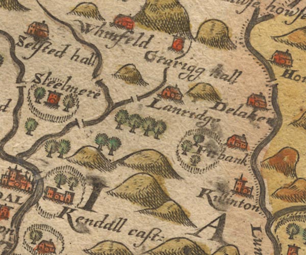 SAX9SD59.jpg Ring of fence palings, trees, with Skelsmergh inside. item:- private collection : 2 Image © see bottom of page |
|
|
|
||
| evidence:- | old map:- Speed 1611 (Wmd) placename:- Sleelmere |
|
| source data:- | Map, hand coloured engraving, The Countie Westmorland and
Kendale the Cheif Towne, scale about 2.5 miles to 1 inch, by
John Speed, 1610, published by George Humble, Popes Head Alley,
London, 1611-12.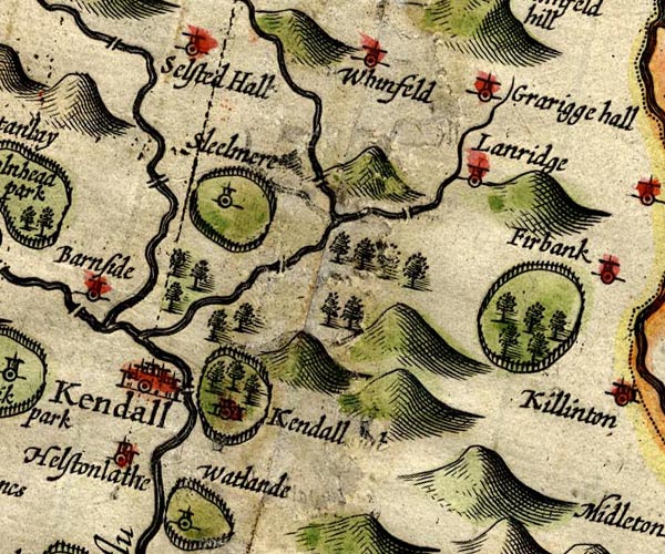 SP14SD59.jpg "Sleelmere" circle, tower, and a ring of fence palings for a park item:- Armitt Library : 2008.14.5 Image © see bottom of page |
|
|
|
||
| evidence:- | old map:- Jansson 1646 placename:- Sleelmere |
|
| source data:- | Map, hand coloured engraving, Cumbria and Westmoria, ie
Cumberland and Westmorland, scale about 3.5 miles to 1 inch, by
John Jansson, Amsterdam, Netherlands, 1646.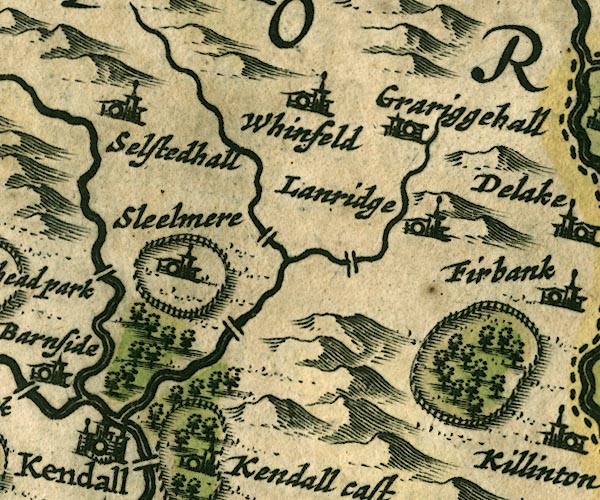 JAN3SD59.jpg "Sleelmere" Buildings and tower. Ring of fence palings. item:- JandMN : 88 Image © see bottom of page |
|
|
|
||
| evidence:- | hearth tax returns:- Hearth Tax 1675 placename:- Skelsmoore hall |
|
| source data:- | Records, hearth tax survey returns, Westmorland, 1674/75. "Skelsmoore hall" in "Patton and Skelsmoore" |
|
|
|
||
| evidence:- | old map:- Morden 1695 (Wmd) placename:- Skelsmere |
|
| source data:- | Map, hand coloured engraving, Westmorland, scale about 2.5 miles to 1 inch, by Robert
Morden, published by Abel Swale, the Unicorn, St Paul's Churchyard, Awnsham, and John
Churchill, the Black Swan, Paternoster Row, London, 1695.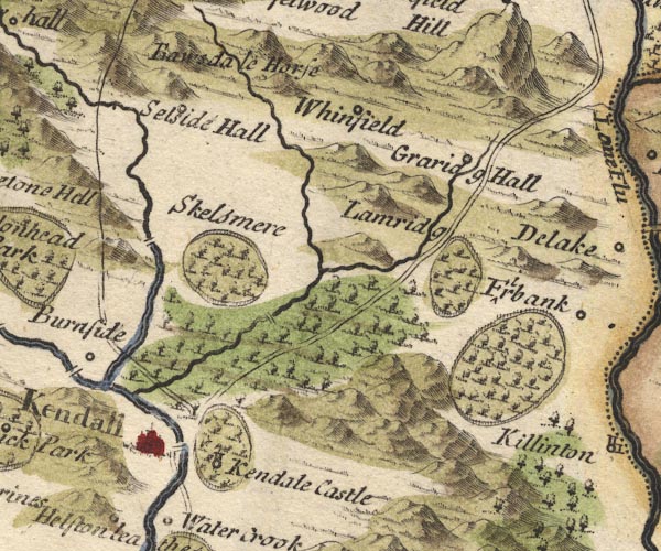 MD10SD59.jpg "Skelsmere" Ring of fence palings, trees?. item:- JandMN : 24 Image © see bottom of page |
|
|
|
||
| evidence:- | old map:- Jefferys 1770 (Wmd) placename:- Skelsmergh Hall |
|
| source data:- | Map, 4 sheets, The County of Westmoreland, scale 1 inch to 1
mile, surveyed 1768, and engraved and published by Thomas
Jefferys, London, 1770.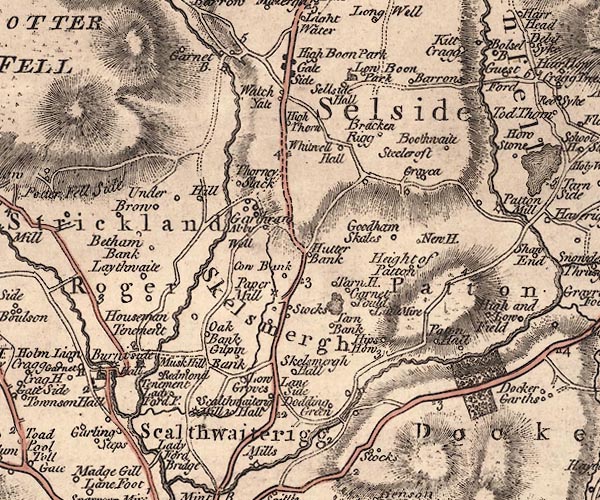 J5SD59NW.jpg "Skelsmergh Hall" circle, labelled in italic lowercase text; settlement, farm, house, or hamlet? item:- National Library of Scotland : EME.s.47 Image © National Library of Scotland |
|
|
|
||
| evidence:- | old photograph:- Bell 1880s-1940s placename:- Skelsmergh Hall |
|
| source data:- | Photograph, Skelsmergh Hall, Skelsmergh, Westmorland, by Herbert Bell, photographer,
Ambleside, Westmorland, 1894.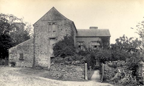 click to enlarge click to enlargeHB0168.jpg Vol.2 no.168 in an album, Examples of Early Domestic and Military Architecture in Westmorland, assembled 1910. ms at bottom:- "168. Skelsmergh Hall. Kendal. K." item:- Armitt Library : 1958.3166.62 Image © see bottom of page |
|
|
|
||
| evidence:- | old print:- Taylor 1892 placename:- Skelsmergh Hall |
|
| source data:- | Print, halftone photograph, Skelsmergh Hall, Skelsmergh, Westmorland, published for
the Cumberland and Westmorland Antiquarian and Archaeological Society, by Titus Wilson,
Kendal, Westmorland, and by Charles Thurnam and Sons, Carlisle, Cumberland, 1892.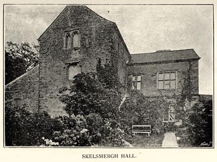 click to enlarge click to enlargeTY5049.jpg Tipped in opposite p.224 of The Old Manorial Halls of Cumberland and Westmorland, by Michael Waistell Taylor. item:- Armitt Library : A785.49 Image © see bottom of page |
|
|
|
||
| evidence:- | site plan:- Historical Monuments 1936 placename:- Skelsmergh Hall |
|
| source data:- | Site plan, uncoloured lithograph, Skelsmergh Hall, Skelsmergh, Westmorland, scale
about 1 to 290, published by Royal Commission on Historical Monuments England, London,
1936.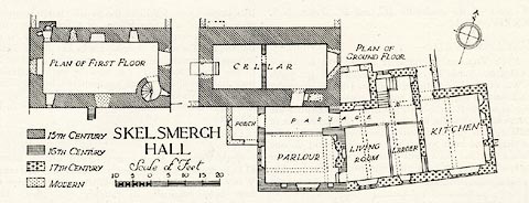 click to enlarge click to enlargeHMW126.jpg On p.212 of the Inventory of the Historical Monuments in Westmorland. printed, lower left "SKELSMERGH / HALL" RCHME no. Wmd, Skelsmergh 2 item:- Armitt Library : A745.127 Image © see bottom of page |
|
|
|
||
| evidence:- | database:- Listed Buildings 2010 placename:- Skelsmergh Hall |
|
| source data:- | courtesy of English Heritage "SKELSMERGH HALL / / A6 / SKELSMERGH / SOUTH LAKELAND / CUMBRIA / II / 75745 / SD5317295914" |
|
|
|
||
| hearsay:- |
The hall, built 15th century, was the home of the Leyburne Family. |
|
|
|
||
| notes:- |
tower and hall |
|
| Perriam, D R &Robinson, J: 1998: Medieval Fortified Buildings of Cumbria: CWAAS::
ISBN 1 873124 23 6; plan and illustrations |
||
|
|
||
 Lakes Guides menu.