 Old Cumbria Gazetteer
 |
 |
|
||||||||||||||||||||||||||||||
| Sca Fell, Eskdale | ||||||||||||||||||||||||||||||||
| Sca Fell | ||||||||||||||||||||||||||||||||
| civil parish:- | Eskdale (formerly Cumberland) | |||||||||||||||||||||||||||||||
| county:- | Cumbria | |||||||||||||||||||||||||||||||
| locality type:- | hill | |||||||||||||||||||||||||||||||
| coordinates:- | NY20680651 (?) | |||||||||||||||||||||||||||||||
| 1Km square:- | NY2006 | |||||||||||||||||||||||||||||||
| 10Km square:- | NY20 | |||||||||||||||||||||||||||||||
| altitude:- | 3163 feet | |||||||||||||||||||||||||||||||
| altitude:- | 964m | |||||||||||||||||||||||||||||||
|
|
||||||||||||||||||||||||||||||||
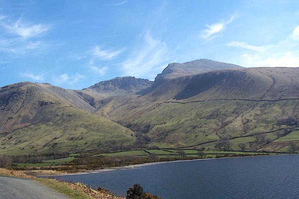 BNM29.jpg Lingmell, Scafell Pike, Scafell from Wastwater. (taken 4.4.2007) 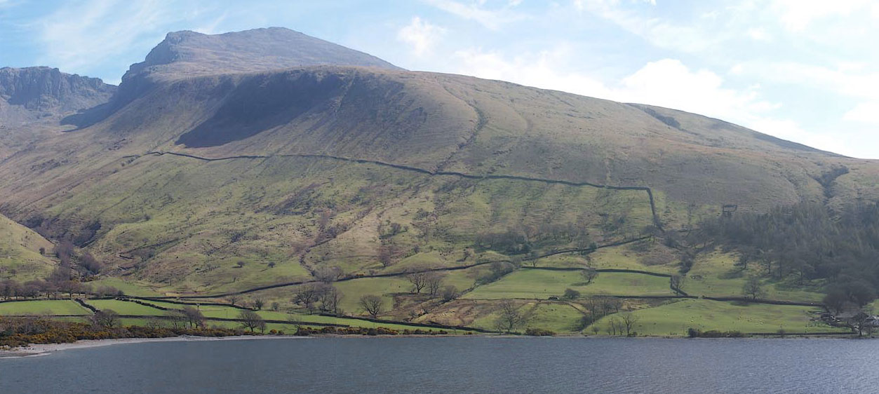 Click to enlarge BNM30.jpg Scafell from Wastwater. (taken 4.4.2007) |
||||||||||||||||||||||||||||||||
|
|
||||||||||||||||||||||||||||||||
| evidence:- | possibly old map:- Gents Mag 1751 placename:- High Sty, The |
|||||||||||||||||||||||||||||||
| source data:- | Map, uncoloured engraving, Map of the Black Lead Mines in
Cumberland, and area, scale about 2 miles to 1 inch, by George
Smith, published in the Gentleman's Magazine, 1751.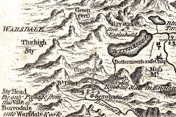 GM1305.jpg "The high Sty" knobbly hillocks; mountains item:- JandMN : 114 Image © see bottom of page |
|||||||||||||||||||||||||||||||
|
|
||||||||||||||||||||||||||||||||
| evidence:- | old map:- Donald 1774 (Cmd) placename:- Sca Fell |
|||||||||||||||||||||||||||||||
| source data:- | Map, hand coloured engraving, 3x2 sheets, The County of Cumberland, scale about 1
inch to 1 mile, by Thomas Donald, engraved and published by Joseph Hodskinson, 29
Arundel Street, Strand, London, 1774.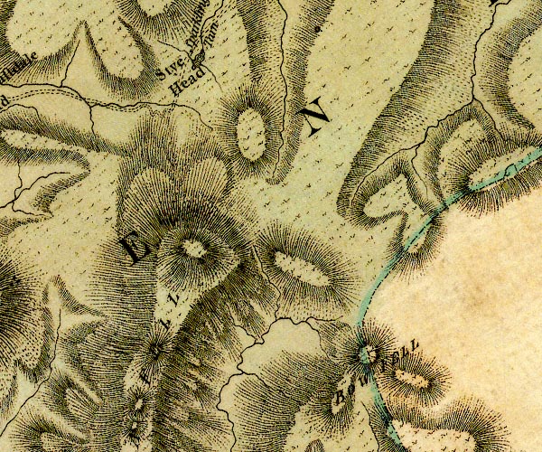 D4NY20NW.jpg 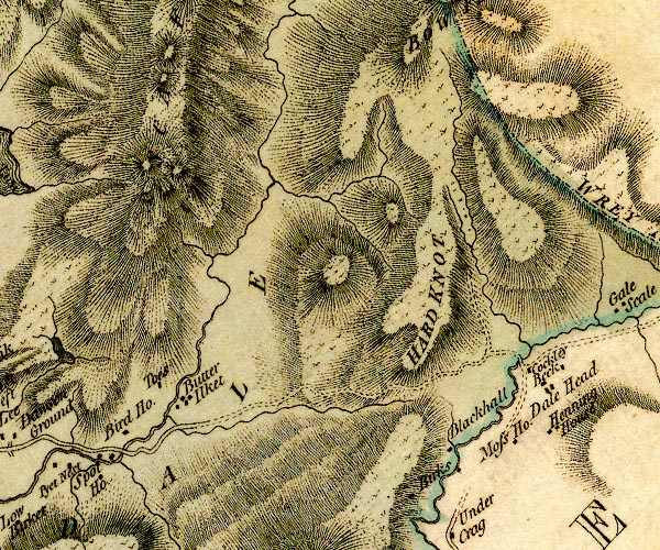 D4NY20SW.jpg "SCA FELL" hill hachuring; a hill or mountain item:- Carlisle Library : Map 2 Images © Carlisle Library |
|||||||||||||||||||||||||||||||
|
|
||||||||||||||||||||||||||||||||
| evidence:- | old map:- Cooper 1808 placename:- Sca Fell |
|||||||||||||||||||||||||||||||
| source data:- | Map, uncoloured engraving, Cumberland, scale about 10.5 miles to
1 inch, drawn and engraved by Cooper, published by R Phillips,
Bridge Street, Blackfriars, London, 1808. click to enlarge click to enlargeCOP3.jpg "Sca Fell" hill hachuring; mountain or hill item:- JandMN : 86 Image © see bottom of page |
|||||||||||||||||||||||||||||||
|
|
||||||||||||||||||||||||||||||||
| evidence:- | old text:- Green 1810 placename:- Schofell |
|||||||||||||||||||||||||||||||
| source data:- | Set of prints, soft ground etchings, Sixty Studies from Nature,
by William Green, Ambleside, Westmorland, drawn 1808-10,
published 1810. goto source goto sourcepage 82:- "... the bridge [Over Beck] may likewise be so viewed as to have Gable or Scho-fell as distances." "..." goto sourcepage 92:- "... From the borders of the lake, Scho-fell and Gable do not much altar (sic) appearance, but Scho-fell from the enclosures at Wastdale Head, displays a strikingly different contour, and if seen at a proper distance from its base, is a sublime object: ..." |
|||||||||||||||||||||||||||||||
|
|
||||||||||||||||||||||||||||||||
| evidence:- | probably old print:- Wilkinson 1810 (plate 42) item:- walker |
|||||||||||||||||||||||||||||||
| source data:- | Print, uncoloured soft ground etching, View on the Banks of Wast Water, Cumberland,
by Joseph Wilkinson, engraved by William Frederick Wells, published by R Ackermann,
Repository of Arts, 101 Strand, London, 1810.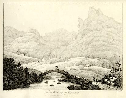 click to enlarge click to enlargeWKN142.jpg Perhaps Sca Fell behind. Plate 42 in Select Views in Cumberland, Westmoreland, and Lancashire. printed at bottom left, right, centre:- "The Revd. Jos. Wilkenson delt. / W. F. Wells sculpt. / View on the Banks of Wast-water. / Published April. 1. 1810. by R. Ackermann. 101. Strand. London." item:- Fell and Rock Climbing Club : MN4.42 Image © see bottom of page |
|||||||||||||||||||||||||||||||
|
|
||||||||||||||||||||||||||||||||
| evidence:- | old print:- Green 1814 (plate 45) placename:- Schofell item:- sheep |
|||||||||||||||||||||||||||||||
| source data:- | Print, tinted soft ground etching, Schofell on Wast Water, Nether Wasdale, Cumberland,
by William Green, Ambleside, Westmorland, 1814.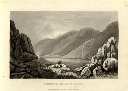 click to enlarge click to enlargeGN1045.jpg Plate 45 in Sixty Small Prints. printed at top right:- "45" printed at bottom:- "SCHOFELL ON WAST WATER. / Published at Ambleside Augst. 1, 1814, by Wm. Green." item:- Armitt Library : A6653.45 Image © see bottom of page |
|||||||||||||||||||||||||||||||
|
|
||||||||||||||||||||||||||||||||
| evidence:- | old print:- Green 1814 (plate 45) placename:- Schofell item:- sheep |
|||||||||||||||||||||||||||||||
| source data:- | Print, uncoloured soft ground etching, Schofell on Wast Water, Nether Wasdale, Cumberland,
by William Green, Ambleside, Westmorland, 1814.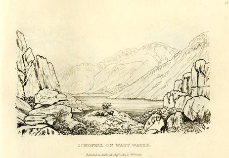 click to enlarge click to enlargeGN0945.jpg Plate 45 in Sixty Small Prints. printed at top right:- "45" printed at bottom:- "SCHOFELL ON WAST WATER. / Published at Ambleside Augst. 1, 1814, by Wm. Green." item:- Armitt Library : A6656.45 Image © see bottom of page |
|||||||||||||||||||||||||||||||
|
|
||||||||||||||||||||||||||||||||
| evidence:- | old text:- Green 1814 placename:- Schofell |
|||||||||||||||||||||||||||||||
| source data:- | Set of prints, soft ground etchings, Sixty Small Prints, with
text, A Description of a Series of Sixty Small Prints, by
William Green, Ambleside, Westmorland, 1814. goto source page 17:- "... the lofty mountain Schofell, which stands at the head of Wast Water." "... ..." goto sourcepage 26:- "..." "SCHOFELL, ON WAST WATER." "Schofell, with its adjoining part of the Screes, is thus viewed [plate 44] from a point between the road and the lake, about half way between its foot and head." |
|||||||||||||||||||||||||||||||
|
|
||||||||||||||||||||||||||||||||
| evidence:- | old print:- Green 1815 placename:- Schofell item:- cattle; clouds |
|||||||||||||||||||||||||||||||
| source data:- | Print, coloured aquatint, Schofell on Wast Water, from Overbeck Bridge? Nether Wasdale,
Cumberland, by William Green, Ambleside, Westmorland, 1815.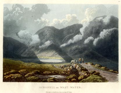 click to enlarge click to enlargeGN0554.jpg Plate 58 in Lake Scenery. printed at upper right:- "58" printed at bottom:- "SCHOFELL on WAST WATER. / Published at Ambleside, June 1, 1815, by Wm. Green." item:- Armitt Library : A6646.54 Image © see bottom of page |
|||||||||||||||||||||||||||||||
|
|
||||||||||||||||||||||||||||||||
| evidence:- | old map:- Otley 1818 placename:- Scawfell |
|||||||||||||||||||||||||||||||
| source data:- | Map, uncoloured engraving, The District of the Lakes,
Cumberland, Westmorland, and Lancashire, scale about 4 miles to
1 inch, by Jonathan Otley, 1818, engraved by J and G Menzies,
Edinburgh, Scotland, published by Jonathan Otley, Keswick,
Cumberland, et al, 1833. OT02NY20.jpg "SCAWFELL" item:- JandMN : 48.1 Image © see bottom of page |
|||||||||||||||||||||||||||||||
|
|
||||||||||||||||||||||||||||||||
| evidence:- | old map:- Hall 1820 (Cmd) placename:- Sca Fell |
|||||||||||||||||||||||||||||||
| source data:- | Map, hand coloured engraving, Cumberland, scale about 21 miles
to 1 inch, engraved by Sidney Hall, published by S Leigh, 18
Strand, London, 1820-31. click to enlarge click to enlargeHA14.jpg "Sca Fell" no symbol item:- JandMN : 91 Image © see bottom of page |
|||||||||||||||||||||||||||||||
|
|
||||||||||||||||||||||||||||||||
| evidence:- | old print:- Fielding and Walton 1821 (plate 29) |
|||||||||||||||||||||||||||||||
| source data:- | Print, coloured aquatint, Wast Water, Nether Wasdale, Cumberland, drawn by Theodore
H A Fielding, published by R Ackermann, 101 Strand, London, 1821.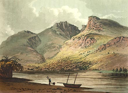 click to enlarge click to enlargeFW0129.jpg Scafell Pike, Mickledore, and Sca Fell in the background. Tipped in opposite p.196 in A Picturesque Tour of the English Lakes. item:- Dove Cottage : 1993.R566.29 Image © see bottom of page |
|||||||||||||||||||||||||||||||
|
|
||||||||||||||||||||||||||||||||
| evidence:- | outline view:- Otley 1823 (4th edn 1830) placename:- Scawfell |
|||||||||||||||||||||||||||||||
| source data:- | Print, engraving, outline view, Mountains round Wastwater as seen from the Strands
in Nether Wasdale, published by Jonathan Otley, Keswick, Cumberland et al, 1830.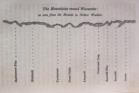 click to enlarge click to enlargeO75E08.jpg p.129 in A Concise Description of the English Lakes, by Jonathan Otley, 4th edition, 1830. "The Mountains round Wastwater: / as seen from the Strands in Nether Wasdale." "Buckbarrow Pike / Middlefell / Yewbarrow / Great Gable / Lingmell / Great-end Crag / Scawfell Pike / Scawfell / Screes" item:- Armitt Library : A1175.8 Image © see bottom of page |
|||||||||||||||||||||||||||||||
|
|
||||||||||||||||||||||||||||||||
| evidence:- | outline view:- Otley 1823 (8th edn 1849) placename:- Scawfell |
|||||||||||||||||||||||||||||||
| source data:- | Engraving, outline view of mountains, Mountains of Wast Water as seen from Nether
Wasdale, drawn by T Binns, engraved by O Jewitt, opposite p.22 of A Descriptive Guide
of the English Lakes, by Jonathan Otley, 8th edition, 1849.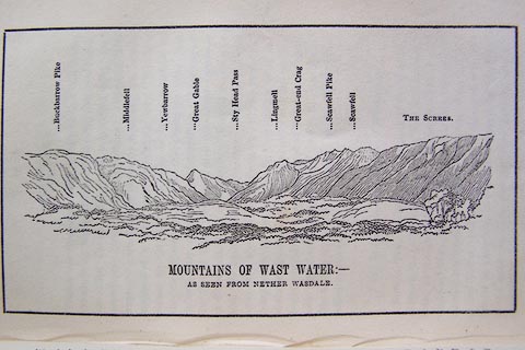 click to enlarge click to enlargeO80E13.jpg item:- Armitt Library : A1180.14 Image © see bottom of page |
|||||||||||||||||||||||||||||||
|
|
||||||||||||||||||||||||||||||||
| evidence:- | outline view:- Otley 1823 (5th edn 1834) placename:- Scawfell |
|||||||||||||||||||||||||||||||
| source data:- | Print, woodcut outline view, Mountains of Wast Water, by
Jonathan Otley, Keswick, Cumberland, 1830.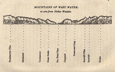 click to enlarge click to enlargeOT2E07.jpg Printed on p.31 of A Concise Description of the English Lakes, by Jonathan Otley, 5th edition, 1834. "THE MOUNTAINS OF WAST WATER: as seen from Nether Wasdale." "Buckbarrow Pike / Middlefell / Yewbarrow / Great Gable / Sty Head Pass / Lingmell / Great-end Crag / Scawfell Pike / Scawfell / Screes" item:- JandMN : 48.8 Image © see bottom of page |
|||||||||||||||||||||||||||||||
|
|
||||||||||||||||||||||||||||||||
| evidence:- | descriptive text:- Otley 1823 (5th edn 1834) placename:- Scawfell item:- altitude, Sca Fell; Mudge, Colonel; moss; geology; lichen geographicus; lichen; Rhizocarpon geographicum (?); viewpoint |
|||||||||||||||||||||||||||||||
| source data:- | Guide book, A Concise Description of the English Lakes, the
mountains in their vicinity, and the roads by which they may be
visited, with remarks on the mineralogy and geology of the
district, by Jonathan Otley, published by the author, Keswick,
Cumberland now Cumbria, by J Richardson, London, and by Arthur
Foster, Kirkby Lonsdale, Cumbria, 1823; published 1823-49,
latterly as the Descriptive Guide to the English Lakes. goto source Page 64:- "SCAWFELL AND THE PIKES." "Scawfell is the name that has generally been given, in maps, to the mountain connecting the heads of Borrowdale, Eskdale, and Wasdale. It is the highest ground in all this mountainous district, and indeed in that part of the united kingdom called England. The several lofty peaks by which it is distinguished are known in the neighbourhood by different names. The two most eminent are stated by Colonel Mudge, to be 3166 and 3092 feet in height: ..." goto sourcePage 65:- "..." "The lower of these points, lying to the south-west, is a bulky mountain - the proper Scawfell; the higher rising from a narrower base, has been called the Pikes. For want of a designation sufficiently explicit, strangers have sometimes been mistakenly directed to the secondary point; and to cross the deep chasm of Mickle Door, by which they are separated, is a work of considerable difficulty; although the direct distance does not exceed three quarters of a mile. ..." "Excepting some tufts of moss, very little vegetation is to be seen upon these summits. They are chiefly composed of rocks, and large blocks of stone piled one upon another; and their weather-worn surfaces prove that they have long remained in their present state. The prevailing rock is a kind of indurated slate, in layers of finer and coarser materials, which gives to the surface a ribbed or furrowed appearance; the finer parts are compact and hard as flint: and here the lichen geographicus appears in peculiar beauty." goto sourcePage 66:- "... the ruggedness of the ground, and the danger of being caught in a cloud - to which, from its situation, it is more subject than its neighbours - altogether conspire against its being visited by any other than hardy pedestrians: and strangers should so calculate their time that night may not overtake them on such places. To be enveloped in a cloud is of itself disagreeable; cloud and night together would be dreadful." goto sourcePage 67:- "..." "The divergency of several vallies from this point, has been compared to the spokes of a wheel; and in tracing their courses upon a map, the simile may be applicable enough; but, upon the spot, the resemblance is not so striking - the mountains run athwart one another in such a way, that little can be seen of the intervening vallies." "..." goto sourcePage 155:- "The SECOND division [of slate rocks] comprehends the mountains of Eskdale, Wasdale, Ennerdale, Borrowdale, Langdale, Grasmere, Patterdale, Martindale, Mardale, and some adjacent places; including the two highest mountains of the district, Scawfell and Helvellyn, as well as the Old Man at Coniston. All our fine towering crags belong to it; and most of the cascades among the lakes fall over it. There are indeed some lofty precipices in the former division; ..." "..." |
|||||||||||||||||||||||||||||||
|
|
||||||||||||||||||||||||||||||||
| evidence:- | descriptive text:- Ford 1839 (3rd edn 1843) placename:- Scafell placename:- Sca Fell item:- altitude, Sca Fell |
|||||||||||||||||||||||||||||||
| source data:- | Guide book, A Description of Scenery in the Lake District, by
Rev William Ford, published by Charles Thurnam, Carlisle, by W
Edwards, 12 Ave Maria Lane, Charles Tilt, Fleet Street, William
Smith, 113 Fleet Street, London, by Currie and Bowman,
Newcastle, by Bancks and Co, Manchester, by Oliver and Boyd,
Edinburgh, and by Sinclair, Dumfries, 1839. goto source "... THE Lake district ... consists of large masses or clusters of mountains, generally terminating in one aspiring and pre-eminent point, with the intermediate valleys occupied either by lakes and their subsidiary tarns, or by winding rivers." "The chief nuclei of these clusters are, Skiddaw and Blencathra, Helvellyn, Fairfield, Coniston Old Man, Blackcomb, Scafell, Gable, Red Pike, Grasmoor, Grisdale Pike, and the Langdale Pikes. Many noble and commanding mountains rise around these, rivalling them in height and grandeur, but still" goto sourcePage iv:- "serving as large buttresses only. In the presentation of endlessly-diversified forms, these Mountains yield to none, however individually inferior they may be, owing to their being seldom seen in a detached point of view; although, on the other hand, they have thus the advantage of forming combinations at once grand and sublime, towering above each other, or rising in ridges, like the mighty billows of the ocean." goto sourcePage 178:- "ELEVATION OF THE MOUNTAINS," "ACCORDING TO DIFFERENT AUTHORITIES."
|
|||||||||||||||||||||||||||||||
|
|
||||||||||||||||||||||||||||||||
| evidence:- | old map:- Ford 1839 map placename:- Sea Fell |
|||||||||||||||||||||||||||||||
| source data:- | Map, uncoloured engraving, Map of the Lake District of
Cumberland, Westmoreland and Lancashire, scale about 3.5 miles
to 1 inch, published by Charles Thurnam, Carlisle, and by R
Groombridge, 5 Paternoster Row, London, 3rd edn 1843. FD02NY10.jpg "Sea Fell" Hill hachuring. item:- JandMN : 100.1 Image © see bottom of page |
|||||||||||||||||||||||||||||||
|
|
||||||||||||||||||||||||||||||||
| evidence:- | old drawing:- Aspland 1840s-60s placename:- Scawfell |
|||||||||||||||||||||||||||||||
| source data:- | Drawing, pencil, Scawfell from Walna Scar, Eskdale, Cumberland, by Theophilus Lindsey
Aspland, 1852.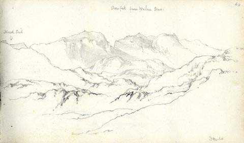 click to enlarge click to enlargeAS0360.jpg "Scawfell from Walna Scar" page number "44" item:- Armitt Library : 1958.390.60 Image © see bottom of page |
|||||||||||||||||||||||||||||||
|
|
||||||||||||||||||||||||||||||||
| evidence:- | old drawing:- Aspland 1840s-60s placename:- Scawfell |
|||||||||||||||||||||||||||||||
| source data:- | Drawing, pencil, Scawfell from Walna Scar, Eskdale, Cumberland, by Theophilus Lindsey
Aspland, 1852.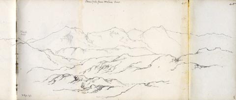 click to enlarge click to enlargeAS0361.jpg "Scawfell from Walna Scar" page number "45" item:- Armitt Library : 1958.390.61 Image © see bottom of page |
|||||||||||||||||||||||||||||||
|
|
||||||||||||||||||||||||||||||||
| evidence:- | old map:- Garnett 1850s-60s H placename:- Scawfell |
|||||||||||||||||||||||||||||||
| source data:- | Map of the English Lakes, in Cumberland, Westmorland and
Lancashire, scale about 3.5 miles to 1 inch, published by John
Garnett, Windermere, Westmorland, 1850s-60s. GAR2NY20.jpg "Pikes / Scawfell" hill hachuring item:- JandMN : 82.1 Image © see bottom of page |
|||||||||||||||||||||||||||||||
|
|
||||||||||||||||||||||||||||||||
| evidence:- | old text:- Martineau 1855 placename:- Scawfell |
|||||||||||||||||||||||||||||||
| source data:- | Guide book, A Complete Guide to the English Lakes, by Harriet
Martineau, published by John Garnett, Windermere, Westmorland,
and by Whittaker and Co, London, 1855; published 1855-76. goto source Page 157:- "... There are four summits which collectively go under the name of Scawfell; viz, the most southerly, which is called simply Scawfell; Scawfell Pike, which is sixty feet higher, and the highest mountain in England (3,160 feet:) and the lower hills, Lingmell and Great End,- the last being the northernmost, and fronting Borrowdale. The Ordnance surveyors set up a staff on a pile of stones on the highest peak; so that there need be no mistake henceforth. The two summits are about three-quarters of a-mile apart, in a straight line; but the great chasm between them, called Mickledore, renders a wide circuit necessary. ..." goto sourcePage 158:- "... The summit is bare of every thing that grows, except moss. Not a blade of grass is to be seen: and it follows that the herdsman and shepherd never have to come here after their charge. Blocks and inclined planes of slate rock, cushioned and draped with mosses, compose the peak. As for what is seen from it,- the best service to the stranger is still to copy portions of that "Letter to a friend" which Mr. Wordsworth published many years ago, and which is the best account we have of the greatest mountain excursion in England. The weather was, however, unusual. The guide said, when on the summit, "I do not know that in my whole life, I was ever, at any season of the year, so high upon the mountains on so calm a day." It was the seventh of October." ""On the summit of the Pike," says the letter, "which we gained after much toil, though without difficulty, there was not a breath of air to stir even the papers containing our refreshment, as they lay spread out upon a rock. The stillness seemed to be not of this world. We paused, and kept silence to listen, and" goto sourcePage :- "no sound could be heard. The Scawfell cataracts were voiceless to us; and there was not an insect to hum in the air. The vales which we had seen from Esk Hause lay yet in view, and, side by side with Eskdale, we now saw the sister Vale of Dunnerdale terminated by the Duddon Sands. But the majesty of the mountains below, and close to us, is not to be conceived. We now beheld the whole mass of Great Gable from its base - the Den of Wastdale at our feet - a gulf immeasurable; Grasmire, and the other mountains of Crummock; Ennerdale and its mountains; and the sea beyond!" ... ... ... "While we were gazing around, 'Look,' I exclaimed, 'at yon ship upon the glittering sea!' 'Is it a ship?' replied our shepherd guide. 'It can be nothing else,' interposed my companion. 'I cannot be mistaken; I am so accustomed to the appearance of ships at sea.' The guide dropped the argument; but, before a minute was gone, he quietly said, 'Now, look at your ship - it is changed into a horse.' So it was; a horse with a gallant neck and head. We laughed heartily; and I hope, when again inclined to be positive, I may remember the ship and the horse upon the glittering sea; and the calm confidence, yet submissiveness, of our wise man of the mountains, who certainly had more knowledge of the clouds than we, whatever might be our knowledge of ships." ""I know not how long we might have remained on the summit of the pike, without a thought of moving, had not our guide warned us that we must not linger, for a storm was coming. We looked in vain to espy" goto sourcePage 160:- "the signs of it. Mountains, vales and sea were touched with the clear light of the sun. 'It is there! said he, pointing to the sea beyond Whitehaven' and there we perceived a light vapour, unnoticeable but by a shepherd accustomed to watch all mountain bodings. We gazed around again, and yet again, unwilling to lose the remembrance of what lay before us in that mountain solitude; and then prepared to depart. Meanwhile, the air changed to cold, and we saw that tiny vapour swelled into mighty masses of cloud, which came boiling over the mountains. Great Gable, Helvellyn and Skiddaw were wrapped in storm; yet Langdale, and the mountains in that quarter, remained all bright in sunshine. Soon the storm reached us; we sheltered under a crag; and almost as rapidly as it had come, it passed away, and left us free to observe the struggles of gloom and sunshine in other quarters. Langdale had now its share; and the Pikes of Langdale were decorated by two splendid rainbows. Before we again reached Esk Hause, every cloud had vanished from every summit."" "We cannot do better than stop at these auspicious words. May the tourist who reads this on the Pike see every cloud vanish from every summit!" |
|||||||||||||||||||||||||||||||
|
|
||||||||||||||||||||||||||||||||
| evidence:- | old text:- Martineau 1855 placename:- Scawfell item:- altitude, Sca Fell |
|||||||||||||||||||||||||||||||
| source data:- | Guide book, A Complete Guide to the English Lakes, by Harriet
Martineau, published by John Garnett, Windermere, Westmorland,
and by Whittaker and Co, London, 1855; published 1855-76. goto source Page 179:- "A TABLE OF THE HEIGHTS OF MOUNTAINS IN THE COUNTIES OF CUMBERLAND, WESTMORLAND, AND LANCASHIRE." "No. : Names of Mountains. : Counties. : Height in Feet above the Sea Level." "2 : Scawfell : Cumberland : 3100" |
|||||||||||||||||||||||||||||||
|
|
||||||||||||||||||||||||||||||||
| evidence:- | old photograph:- Bell 1880s-1940s |
|||||||||||||||||||||||||||||||
| source data:- | Photograph, black and white, Sca Fell face and Mickledore, Eskdale, Cumberland, by
Herbert Bell, photographer, Ambleside, Westmorland, 1890s.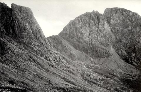 click to enlarge click to enlargeHB0907.jpg stamped at reverse:- "HERBERT BELL / Photographer / AMBLESIDE" item:- Armitt Library : ALPS582 Image © see bottom of page |
|||||||||||||||||||||||||||||||
|
|
||||||||||||||||||||||||||||||||
| evidence:- | old photograph:- Bell 1880s-1940s |
|||||||||||||||||||||||||||||||
| source data:- | Photograph, black and white, Sca Fell face, Eskdale, Cumberland, by Herbert Bell,
photographer, Ambleside, Westmorland, 1890s.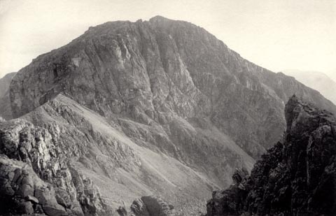 click to enlarge click to enlargeHB0884.jpg item:- Armitt Library : ALPS555 Image © see bottom of page |
|||||||||||||||||||||||||||||||
|
|
||||||||||||||||||||||||||||||||
| evidence:- | old photograph:- Bell 1880s-1940s item:- snow |
|||||||||||||||||||||||||||||||
| source data:- | Photograph, black and white, Great Gable and Pillar from Sca Fell, Cumberland, by
Herbert Bell, photographer, Ambleside, Westmorland, 1890s. click to enlarge click to enlargeHB0577.jpg internegative at lower right:- "H. Bell" item:- Armitt Library : ALPS237 Image © see bottom of page |
|||||||||||||||||||||||||||||||
|
|
||||||||||||||||||||||||||||||||
| evidence:- | old photograph:- Bell 1880s-1940s |
|||||||||||||||||||||||||||||||
| source data:- | Photograph, black and white, Sca Fell, Eskdale, Cumberland, by Herbert Bell, photographer,
Ambleside, Westmorland, 1890s. click to enlarge click to enlargeHB0701.jpg stamped on reverse:- "HERBERT BELL / Photographer / AMBLESIDE" item:- Armitt Library : ALPS365 Image © see bottom of page |
|||||||||||||||||||||||||||||||
|
|
||||||||||||||||||||||||||||||||
| evidence:- | old photograph:- Bell 1880s-1940s |
|||||||||||||||||||||||||||||||
| source data:- | Photograph, black and white, Sca Fell from Lingmell, Eskdale, Cumberland, by Herbert
Bell, photographer, Ambleside, Westmorland, 1890s. click to enlarge click to enlargeHB0702.jpg item:- Armitt Library : ALPS366 Image © see bottom of page |
|||||||||||||||||||||||||||||||
|
|
||||||||||||||||||||||||||||||||
| evidence:- | old photograph:- Bell 1880s-1940s |
|||||||||||||||||||||||||||||||
| source data:- | Photograph, black and white, Sca Fell, Eskdale, Cumberland, by Herbert Bell, photographer,
Ambleside, Westmorland, 1890s. click to enlarge click to enlargeHB0703.jpg internegative at lower right:- "H. Bell" item:- Armitt Library : ALPS367 Image © see bottom of page |
|||||||||||||||||||||||||||||||
|
|
||||||||||||||||||||||||||||||||
| evidence:- | old photograph:- Bell 1880s-1940s |
|||||||||||||||||||||||||||||||
| source data:- | Photograph, black and white, Sca Fell from Scafell Pike, Eskdale, Cumberland, by Herbert
Bell, photographer, Ambleside, Westmorland, 1890s.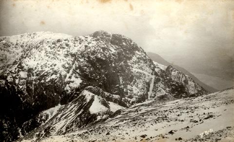 click to enlarge click to enlargeHB0704.jpg internegative at lower right:- "H. Bell" item:- Armitt Library : ALPS368 Image © see bottom of page |
|||||||||||||||||||||||||||||||
|
|
||||||||||||||||||||||||||||||||
| evidence:- | old photograph:- Bell 1880s-1940s |
|||||||||||||||||||||||||||||||
| source data:- | Photograph, black and white, view of Scafell Pike from near Esk Hause? Eskdale, Cumberland,
by Herbert Bell, photographer, Ambleside, Westmorland, 1890s.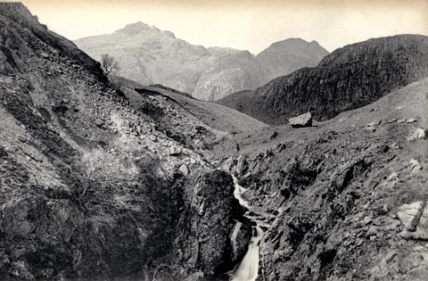 click to enlarge click to enlargeHB0705.jpg This has been described as 'from Esk Head'; looking at the head of the River Esk is looking N with Sca fell to the WSW. stamped on reverse:- "HERBERT BELL / Photographer / AMBLESIDE" item:- Armitt Library : ALPS369 Image © see bottom of page |
|||||||||||||||||||||||||||||||
|
|
||||||||||||||||||||||||||||||||
| evidence:- | old text:- Gents Mag item:- sheep; snow; winter |
|||||||||||||||||||||||||||||||
| source data:- | Magazine, The Gentleman's Magazine or Monthly Intelligencer or
Historical Chronicle, published by Edward Cave under the
pseudonym Sylvanus Urban, and by other publishers, London,
monthly from 1731 to 1922. goto source Gentleman's Magazine 1890 part 1 p.529 "..." "... During the long and terrible winter of 1886 the fell sheep suffered" |
|||||||||||||||||||||||||||||||
|
|
||||||||||||||||||||||||||||||||
| evidence:- | old text:- Gents Mag 1890 |
|||||||||||||||||||||||||||||||
| source data:- | goto source Gentleman's Magazine 1890 part 1 p.530 "severely. On the higher runs they perished by hundreds. The farmers (four in number) of the farms lying contiguous to Sca Fell alone lost fifteen hundred sheep out of an aggregate of about six thousand. The whitened bones and fleeces of these were dotted everywhere about the fells, and to the hill farmers in these times of depression this fact almost spells ruin. The skeletons were bleached, and the only things that profited by the protracted snows were the peregrines and ravens of the crags. These birds still find an asylum in the deepest recesses of the mountains." "In these desolate hill tracts winter usually lasts through seven months of the year. Layer upon layer of snow becomes hard frozen, and upon the highest peaks of Skiddaw and Sca Fell this often lies till June or July. ..." |
|||||||||||||||||||||||||||||||
|
|
||||||||||||||||||||||||||||||||
| evidence:- | old print:- Heaton Cooper 1905 (edn 1908) placename:- Scawfell |
|||||||||||||||||||||||||||||||
| source data:- | Print, colour halftone, Wastwater and Scawfell, Nether Wasdale, Cumberland, from a
watercolour painting by Alfred Heaton Cooper, published by Adam and Charles Black,
London, 2nd edn 1908.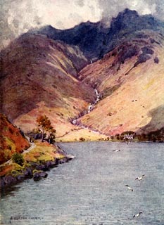 click to enlarge click to enlargeHC0131.jpg Opposite p.84 of The English Lakes, painted by Alfred Heaton Cooper, described by William T Palmer. printed at tissue opposite the print:- "WASTWATER AND SCAWFELL" printed at signed lower left:- "A HEATON COOPER" item:- JandMN : 468.31 Image © see bottom of page |
|||||||||||||||||||||||||||||||
|
|
||||||||||||||||||||||||||||||||
| evidence:- | old map:- Postlethwaite 1877 (3rd edn 1913) placename:- Sca Fell |
|||||||||||||||||||||||||||||||
| source data:- | Map, uncoloured engraving, Map of the Lake District Mining Field, Westmorland, Cumberland,
Lancashire, scale about 5 miles to 1 inch, by John Postlethwaite, published by W H
Moss and Sons, 13 Lowther Street, Whitehaven, Cumberland, 1877 edn 1913.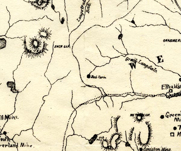 PST2NY20.jpg "[SCA] FELL" hill hachuring item:- JandMN : 162.2 Image © see bottom of page |
|||||||||||||||||||||||||||||||
|
|
||||||||||||||||||||||||||||||||
| evidence:- | old print:- Reynolds 1915 placename:- Scawfell |
|||||||||||||||||||||||||||||||
| source data:- | Print, colour halftone, Wastwater and Scawfell, Nether Wasdale, Cumberland, from a
painting by Alfred Heaton Cooper, published by Adam and Charles Black, London, 1915.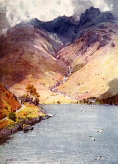 click to enlarge click to enlargeREY615.jpg "A HEATON COOPER" "WASTWATER AND SCAWFELL." item:- JandMN : 1071.15 Image © see bottom of page |
|||||||||||||||||||||||||||||||
|
|
||||||||||||||||||||||||||||||||
| evidence:- | old photograph:- Marr 1916 placename:- Scawfell |
|||||||||||||||||||||||||||||||
| source data:- | Photograph, halftone print, Scawfell, Eskdale, Cumberland, 1916.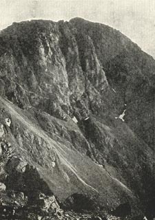 click to enlarge click to enlargeMA1208.jpg item:- JandMN : 173.16 Image © see bottom of page |
|||||||||||||||||||||||||||||||
|
|
||||||||||||||||||||||||||||||||
| evidence:- | outline view:- Seascale 1920s-30s placename:- Scawfell |
|||||||||||||||||||||||||||||||
| source data:- | Print, uncoloured engraving, outline view, mountains from Seascale, published by Edward
Burrow and Son, Cheltenham, Gloucestershire, 1920s-30s.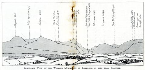 click to enlarge click to enlargeSES113.jpg "PANORAMIC VIEW OF THE WESTERN MOUNTAINS OF LAKELAND AS SEEN FROM SEASCALE." "... Scawfell 3162" item:- JandMN : 1079.13 Image © see bottom of page |
|||||||||||||||||||||||||||||||
|
|
||||||||||||||||||||||||||||||||
| evidence:- | old print:- placename:- Scafell Group |
|||||||||||||||||||||||||||||||
| source data:- | Print, colour print, Scafell Group from Beck Head, Cumberland, from a painting by
W Heaton Cooper, 1930s.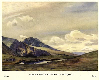 click to enlarge click to enlargePR0080.jpg Included in The Hills of Lakeland, published by Frank Peters Publishing, Kendal, Westmorland, 1938 onwards. printed at bottom left, right, centre:- "Pl.45 / Q.113 / SCAFELL GROUP FROM BECK HEAD (p.113)" item:- Dove Cottage : 2008.107.80 Image © see bottom of page |
|||||||||||||||||||||||||||||||
|
|
||||||||||||||||||||||||||||||||
| evidence:- | old print:- MacBride 1922 placename:- Scawfells |
|||||||||||||||||||||||||||||||
| source data:- | Print, colour, Scawfells from Hardknott Pass, by Alfred Heaton Cooper, published by
Adam and Charles Black, 4-6 Soho Square, London, 2nd edn 1928.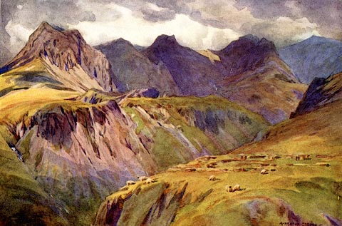 click to enlarge click to enlargeMB0105.jpg Tipped in opposite p.21 in Wild Lakeland by MacKenzie MacBride. printed at bottom:- "THE SCAWFELLS FROM HARDKNOTT PASS" signed at lower right:- "A. HEATON COOPER" item:- JandMN : 195.7 Image © see bottom of page |
|||||||||||||||||||||||||||||||
|
|
||||||||||||||||||||||||||||||||
| evidence:- | outline view:- Jenkinson 1875 placename:- Scawfell |
|||||||||||||||||||||||||||||||
| source data:- | Print, lithograph, outline view, Panoramic Sketches from Skiddaw, Cumberland, by Edwin
A Pettitt, London, published by Edward Stanford, 55 Charing Cross, London, 1875. click to enlarge click to enlargeJk01E2.jpg "... Scawfell ..." item:- JandMN : 28.8 Image © see bottom of page |
|||||||||||||||||||||||||||||||
|
|
||||||||||||||||||||||||||||||||
| evidence:- | outline view:- Jenkinson 1875 placename:- Scawfell |
|||||||||||||||||||||||||||||||
| source data:- | Print, lithograph, outline view, Panoramic Sketches from Scawfell Pike, Cumberland,
by Edwin A Pettitt, London, published by Edward Stanford, 55 Charing Cross, London,
1875. click to enlarge click to enlargeJk01E3.jpg "... Scawfell ..." item:- JandMN : 28.9 Image © see bottom of page |
|||||||||||||||||||||||||||||||
|
|
||||||||||||||||||||||||||||||||
| evidence:- | old print:- Prior 1865 placename:- Scafell |
|||||||||||||||||||||||||||||||
| source data:- | Print, uncoloured engraving, Scafell and Bowfell from Hardknott, Cumberland, published
by John Garnett, Windermere, Westmorland, and by Simpkin, Marshall and Co, London,
1865.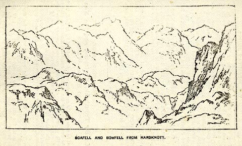 click to enlarge click to enlargePI0115.jpg Included on page 101 of the guide book, Ascents and Passes in the Lake District of England, by Herman Prior. printed at bottom:- "SCAFELL AND BOWFELL FROM HARDKNOTT." item:- JandMN : 235.17 Image © see bottom of page |
|||||||||||||||||||||||||||||||
|
|
||||||||||||||||||||||||||||||||
| evidence:- | old print:- Prior 1865 placename:- Scafell |
|||||||||||||||||||||||||||||||
| source data:- | Print, uncoloured engraving, Sty Head Tarn, Scafell Pike, and Scafell, in Borrowdale
and in Eskdale, Cumberland, published by John Garnett, Windermere, Westmorland, and
by Simpkin, Marshall and Co, London, 1865.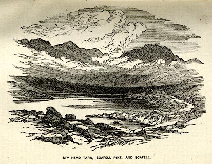 click to enlarge click to enlargePI0106.jpg Included on page 39 of the guide book, Ascents and Passes in the Lake District of England, by Herman Prior. printed at bottom:- "STY HEAD TARN, SCAFELL PIKE, AND SCAFELL." item:- JandMN : 235.8 Image © see bottom of page |
|||||||||||||||||||||||||||||||
|
|
||||||||||||||||||||||||||||||||
| evidence:- | old print:- placename:- Scawfell |
|||||||||||||||||||||||||||||||
| source data:- | Print, uncoloured engraving, Scawfell over Wastwater, Cumberland, engraved by M Jackson,
published late 19th century?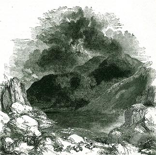 click to enlarge click to enlargePR0341.jpg On a page of The Land We Live In. printed at lower left:- "M. JACKSON. SC" printed at bottom:- "3.- SCAWFELL OVER WASTWATER." item:- Dove Cottage : 2008.107.341 Image © see bottom of page |
|||||||||||||||||||||||||||||||
|
|
||||||||||||||||||||||||||||||||
| evidence:- | outline view:- Black 1856 (23rd edn 1900) placename:- Scawfell |
|||||||||||||||||||||||||||||||
| source data:- | Print, lithograph, Outline Views, Skiddaw and Derwent Water - Mountains as seen at
Lodore Hotel, and Mountains as seen at the Third Gate on Ascending Latrigg on the
Way to Skiddaw, by J Flintoft, Keswick, Cumberland, engraved by R Mason, Edinburgh,
Lothian, about 1900.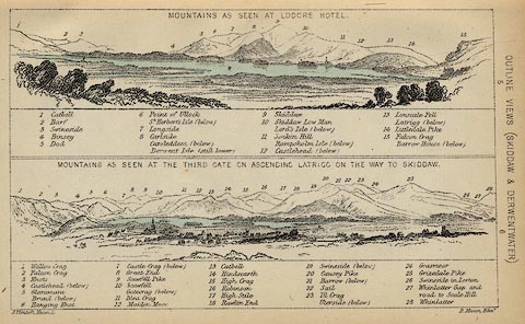 click to enlarge click to enlargeBC08E4.jpg "... 10 Scawfell ..." item:- JandMN : 37.14 Image © see bottom of page |
|||||||||||||||||||||||||||||||
|
|
||||||||||||||||||||||||||||||||
| evidence:- | outline view:- Black 1856 (23rd edn 1900) placename:- Scawfell |
|||||||||||||||||||||||||||||||
| source data:- | Print, lithograph, Outline Views, Haws and Wastwater - Mountains as seen from Burn-Banks
near the Foot of Hawes Water, and Mountains as seen near Nether Wastdale at the First
Bridge on the road to Wast-Water, by J Flintoft, Keswick, Cumberland, engraved by
R Mason, Edinburgh, Lothian, about 1900.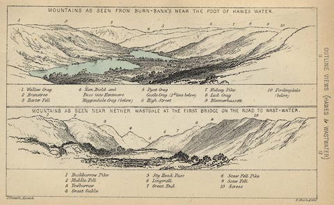 click to enlarge click to enlargeBC08E6.jpg "... 9 Scaw Fell ..." item:- JandMN : 37.21 Image © see bottom of page |
|||||||||||||||||||||||||||||||
|
|
||||||||||||||||||||||||||||||||
| evidence:- | outline view:- Linton 1852 placename:- Scawfell |
|||||||||||||||||||||||||||||||
| source data:- | Print, engraving, outline views, Mountains as Seen from the Esk Viaduct, the Eskmeals
Viaduct, and Mountains as Seen from the Viaduct near Drigg, the Irt Viaduct, Whitehaven
and Furness Junction Railway, Cumberland, engraved by W H Lizars, Edinburgh, published
by Whittaker and Co, London, and by R Gibson and Son and by Callander and Dixon, Whitehaven,
Cumberland, 1852.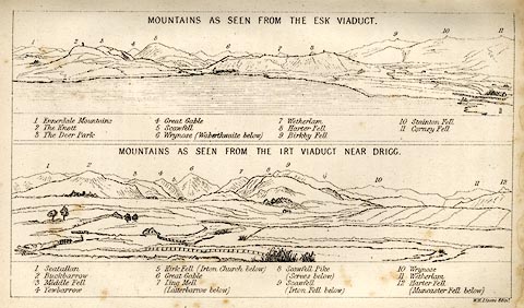 click to enlarge click to enlargeLN1E13.jpg Tipped in opposite p.86 of A Handbook of the Whitehaven and Furness Railway, by John Linton. item:- Armitt Library : A1158.11 Image © see bottom of page |
|||||||||||||||||||||||||||||||
|
|
||||||||||||||||||||||||||||||||
| evidence:- | outline view:- Black 1841 (3rd edn 1846) placename:- Scaw Fell |
|||||||||||||||||||||||||||||||
| source data:- | Print, engraving, outline view, Mountains as seen at Lowdore Inn, and Mountains as
seen at the Third Gate on Ascending Latrigg on the Way to Skiddaw, by J Flintoft,
Keswick, Cumberland, engraved by R Mason, Edinburgh, Lothian, about 1846.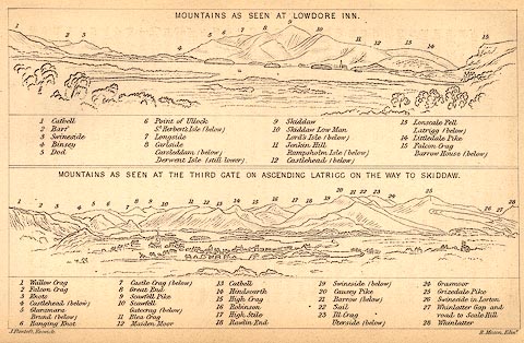 click to enlarge click to enlargeBC02E4.jpg "... 10 Scawfell ..." item:- JandMN : 32.7 Image © see bottom of page |
|||||||||||||||||||||||||||||||
|
|
||||||||||||||||||||||||||||||||
| evidence:- | outline view:- Black 1841 (3rd edn 1846) placename:- Scaw Fell |
|||||||||||||||||||||||||||||||
| source data:- | Print, engraving, outline view, Mountains as seen from Burn Banks near the Foot of
Hawes Water, and Mountains as seen near Strands in Wastdale at the First bridge on
the Road to Wast Water, by J Flintoft, Keswick, Cumberland, engraved by R Mason, Edinburgh,
Lothian, about 1846.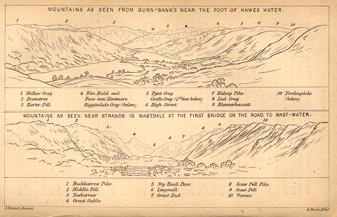 click to enlarge click to enlargeBC02E8.jpg "... 9 Scaw Fell ..." item:- JandMN : 32.12 Image © see bottom of page |
|||||||||||||||||||||||||||||||
|
|
||||||||||||||||||||||||||||||||
| evidence:- | old print:- Rose 1832-35 (vol.3 fpc) placename:- Scawfell |
|||||||||||||||||||||||||||||||
| source data:- | Print, uncoloured engraving, Eskdale, Looking towards Scawfell, Cumberland, drawn
by G Pickering, engraved by J Varrall, published by Fisher, Son and Co, London, 1835.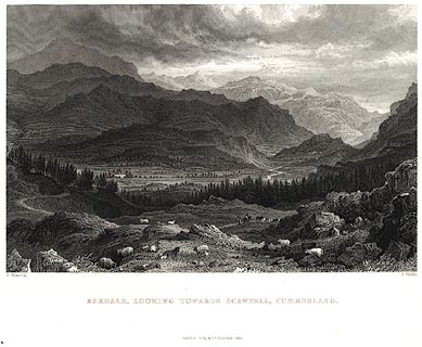 click to enlarge click to enlargePR0032.jpg vol.3 frontispiece of the set of prints, Westmorland, Cumberland, Durham and Northumberland Illustrated. printed at bottom left, right, centre:- "G. Pickering. / J. Varrall. / ESKDALE, LOOKING TOWARDS SCAWFELL, CUMBERLAND. / FISHER, SON &CO. LONDON, 1835." item:- Dove Cottage : 2008.107.32 Image © see bottom of page |
|||||||||||||||||||||||||||||||
|
|
||||||||||||||||||||||||||||||||
| evidence:- | old print:- Rose 1832-35 |
|||||||||||||||||||||||||||||||
| source data:- | Print, engraving, Wastdale Head, Scawfell Pikes, Cumberland, by Thomas Allom, engraved
by S Lacey, 1833.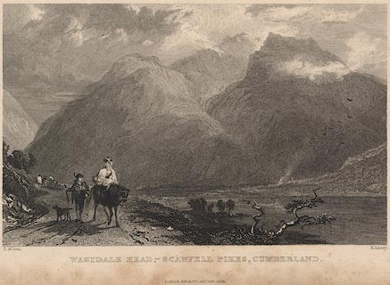 click to enlarge click to enlargeR258.jpg "Wastdale Head, Scawfell Pikes, Cumberland" item:- JandMN : 96.19 Image © see bottom of page |
|||||||||||||||||||||||||||||||
|
|
||||||||||||||||||||||||||||||||
 ascent 1855 ascent 1855 |
||||||||||||||||||||||||||||||||
|
|
||||||||||||||||||||||||||||||||
 BNU09.jpg Scafell Pike, Hollowstones and Scafell. (taken 5.6.2007) 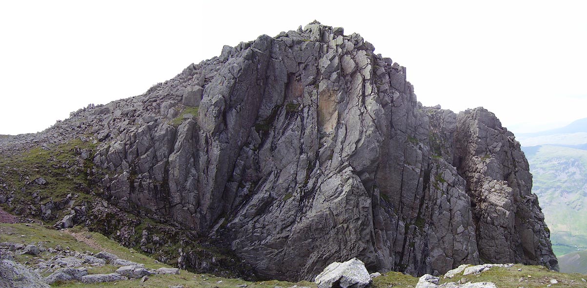 Click to enlarge BNV03.jpg Deep Gill Buttress. (taken 9.6.2007) 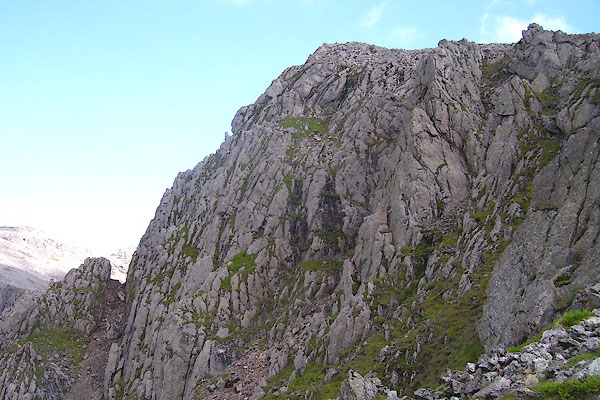 BNV04.jpg Deep Gill Buttress, West Wall Traverse. (taken 9.6.2007) 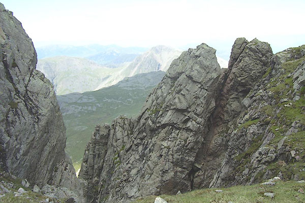 BNV05.jpg Deep Gill Pinnacle. (taken 9.6.2007) 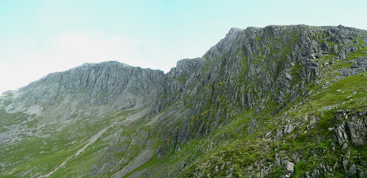 Click to enlarge BNV06.jpg (taken 9.6.2007) 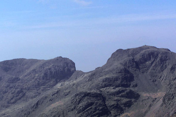 BQL57.jpg Sca Fell, Mickledore and Scafell Pikes from Bow Fell. (taken 20.4.2009) 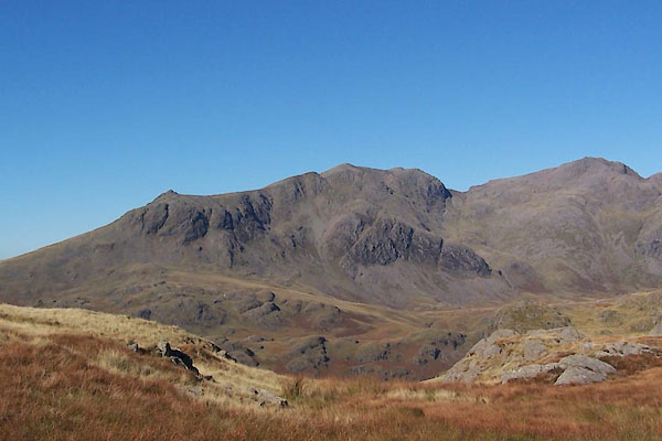 BTR12.jpg Slight Side, Sca Fell, Scafell Pikes, from Hard Knott (taken 11.10.2010) 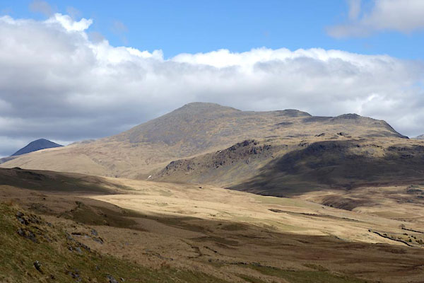 BYG21.jpg From Eskdale Moor. (taken 27.4.2013) 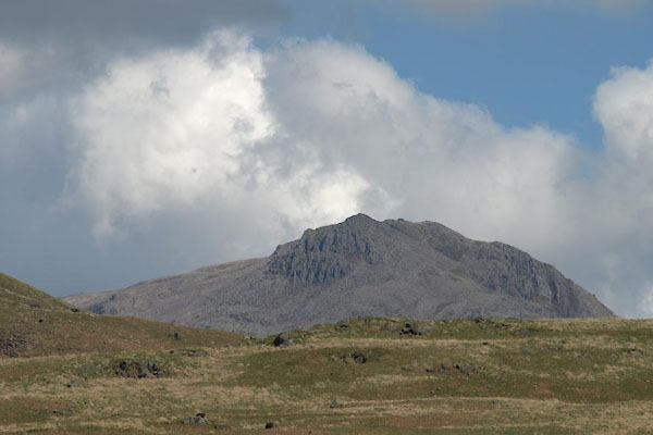 BYL52.jpg From Cockley Beck. (taken 4.6.2013) 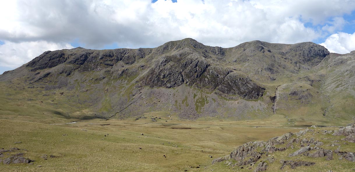 Click to enlarge BYN09.jpg From Moasdale. (taken 4.6.2013)  BOF65.jpg From Whitecombe Moss. (taken 1.10.2007)  Click to enlarge BOV28.jpg Outline view from Stybarrow Dodd; Bowfell, Esk Pike, Scafell, Lingmell, Great Gable. (taken 17.3.2008) 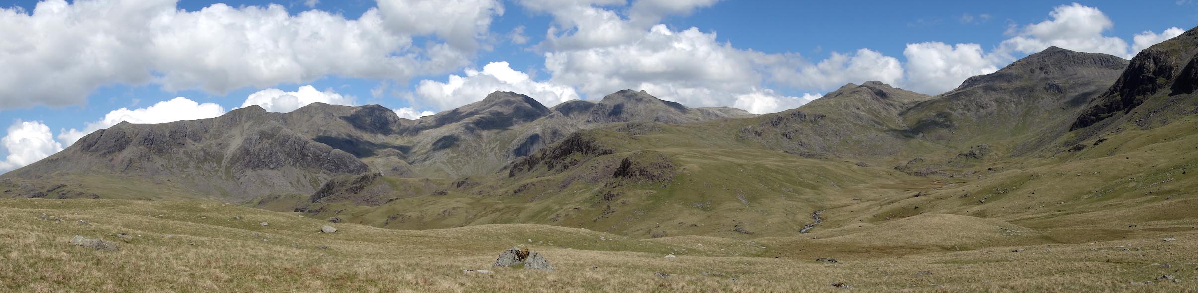 Click to enlarge BYN13.jpg The Sca Fell range - Sca Fell, Scafell Pikes, Esk Pike, Bow Fell. View over Lincove Beck, Pianet Knott in foreground. (taken 4.6.2013) 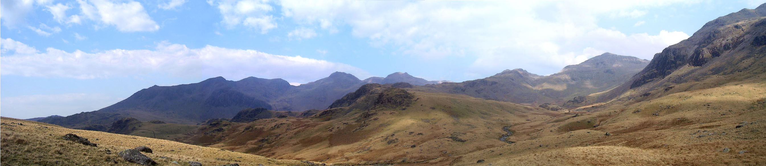 Click to enlarge BNL49.jpg The Sca Fell range - Sca Fell, Scafell Pikes, Esk Pike, Bow Fell. View over Lincove Beck, Pianet Knott in foreground. (taken 26.3.2007) |
||||||||||||||||||||||||||||||||
|
|
||||||||||||||||||||||||||||||||
| notes:- |
This mountain is a 'Furth Munro'. |
|||||||||||||||||||||||||||||||
|
|
||||||||||||||||||||||||||||||||
| observation:- |
BEWARE. The naming of bits of Sca Fell and Scafell Pike is of great interest to both
climbers and walkers. It is said the 'Scafell is the Mecca of the climbing world'.
Both that world, represented by the Fell and Rock Climbing Club in an admirable series
of guides, and the Ordnance Survey in their admirable maps, seem to make a mess of
naming and labelling bits of the mountain. Wainwright is more helpful. |
|||||||||||||||||||||||||||||||
|
|
||||||||||||||||||||||||||||||||
Lakes Guides menu.