 Old Cumbria Gazetteer
 |
 |
|
| Rey Cross, Durham | ||
| Rey Cross | ||
| Roy Cross | ||
| county:- | Durham | |
| locality type:- | cross | |
| coordinates:- | NY904123 | |
| 1Km square:- | NY9012 | |
| 10Km square:- | NY91 | |
|
|
||
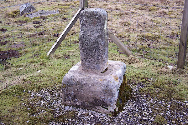 BNG31.jpg (picture avoiding litter, road noise, etc.) (taken 23.2.2007) |
||
|
|
||
| evidence:- | probably old map:- Saxton 1579 |
|
| source data:- | Map, hand coloured engraving, Westmorlandiae et Cumberlandiae Comitatus ie Westmorland
and Cumberland, scale about 5 miles to 1 inch, by Christopher Saxton, London, engraved
by Augustinus Ryther, 1576, published 1579-1645.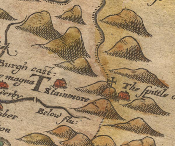 Sax9NY81.jpg Cross atop a hillock. item:- private collection : 2 Image © see bottom of page |
|
|
|
||
| evidence:- | old map:- Morden 1695 (Wmd) placename:- Rear Cross placename:- Roycross |
|
| source data:- | Map, hand coloured engraving, Westmorland, scale about 2.5 miles to 1 inch, by Robert
Morden, published by Abel Swale, the Unicorn, St Paul's Churchyard, Awnsham, and John
Churchill, the Black Swan, Paternoster Row, London, 1695.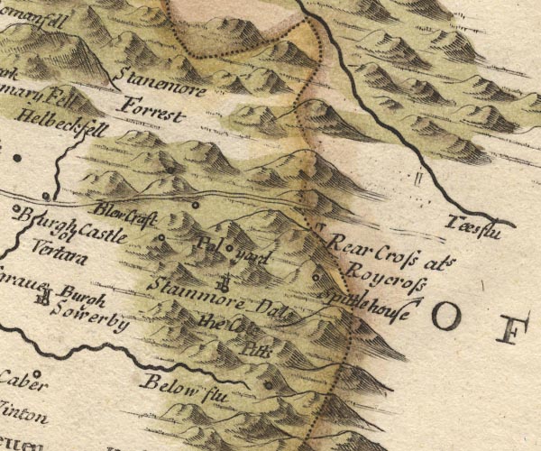 MD10NY81.jpg "Rear Cross als Roycross" Stone on the county boundary. item:- JandMN : 24 Image © see bottom of page |
|
|
|
||
| evidence:- | old map:- Simpson 1746 map (Wmd) placename:- Rey Cross placename:- Rear |
|
| source data:- | Map, uncoloured engraving, Westmorland, scale about 8 miles to 1
inch, printed by R Walker, Fleet Lane, London, 1746.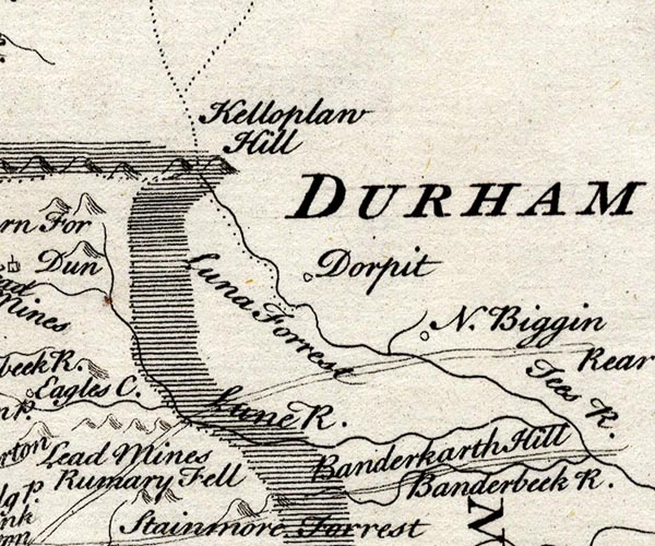 SMP2NYW.jpg "Rear"  SMP2NYV.jpg "Rey Cross" item:- Dove Cottage : 2007.38.59 Image © see bottom of page |
|
|
|
||
| evidence:- | old map:- Jefferys 1770 (Wmd) placename:- Rear Cross |
|
| source data:- | Map, 4 sheets, The County of Westmoreland, scale 1 inch to 1
mile, surveyed 1768, and engraved and published by Thomas
Jefferys, London, 1770.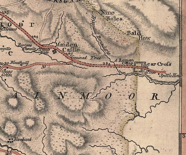 J5NY81SE.jpg "Rear Cross" no symbol item:- National Library of Scotland : EME.s.47 Image © National Library of Scotland |
|
|
|
||
| evidence:- | old map:- Laurie and Whittle 1806 placename:- Bear Cross |
|
| source data:- | Road map, Continuation of the Roads to Glasgow and Edinburgh,
scale about 10 miles to 1 inch, by Nathaniel Coltman? 1806,
published by Robert H Laurie, 53 Fleet Street, London, 1834. click to enlarge click to enlargeLw21.jpg "Bear Cross 254½" place; distance from London; on county boundary item:- private collection : 18.21 Image © see bottom of page |
|
|
|
||
| evidence:- | old map:- Hall 1820 (Wmd) placename:- Rey Cross |
|
| source data:- | Map, hand coloured engraving, Westmoreland ie Westmorland, scale
about 14.5 miles to 1 inch, by Sidney Hall, London, 1820,
published by Samuel Leigh, 18 Strand, London, 1820-31. click to enlarge click to enlargeHA18.jpg "Rey Cross" circle; on county boundary item:- Armitt Library : 2008.14.58 Image © see bottom of page |
|
|
|
||
| evidence:- | old text:- Gents Mag placename:- Reicrois placename:- Rerecros |
|
| source data:- | Magazine, The Gentleman's Magazine or Monthly Intelligencer or
Historical Chronicle, published by Edward Cave under the
pseudonym Sylvanus Urban, and by other publishers, London,
monthly from 1731 to 1922. goto source goto sourceGentleman's Magazine 1825 part 1 p.414 From the Compendium of County History:- "1st or 2d century. Marit[ ], King of the Britons, defeated Roderic, or Rotheringer, a Pictish general from Scythia, upon the mountain now called Stanemore; in memory whereof Reicrois or Rerecros (a red or royal cross) was erected, and from him Westmorland takes its names." |
|
|
|
||
| evidence:- | old text:- Gents Mag 1825 placename:- Rerecross |
|
| source data:- | goto source Gentleman's Magazine 1825 part 1 p.516 "Compendium of County History. - Westmorland." "RERECROSS on Stanemore is the boundary between Westmorland and Yorkshire. Only a fragment of it now remains. At the neighbouring turnpike house is a cylindrical stone with COH . V. probably a Roman miliary." |
|
|
|
||
| evidence:- | old print:- Calverley 1899 item:- cross; boundary stone; county boundary mark; coat of arms, royal |
|
| source data:- | ... just over the border in Yorkshire, Reycross:- 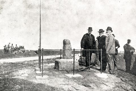 click to enlarge click to enlargeCV1142.jpg Photograph by W L Fletcher. John Speed, 1623, said:- "A stone crosse, on one side of whose shaft stood the picture, and armes, of the King of England, and on the other the image and armes of the king and kingdome of Scotland." item:- JandMN : 190 Image © see bottom of page |
|
|
|
||
| evidence:- | old print:- Bogg 1898 placename:- Rere Cross placename:- Roi Cross item:- cross; boundary stone |
|
| source data:- | Print, engraving, Stainmoor, Rere or Roi Cross, ie Rey Cross, Durham, by Whiteley
Brook, published by Edmund Bogg, 3 Woodhouse Lane, and James Miles, Guildford Street,
Leeds, Yorkshire, 1898.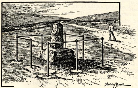 click to enlarge click to enlargeBGG126.jpg Included on p.106 of Lakeland and Ribblesdale, by Edmund Bogg. item:- JandMN : 231.26 Image © see bottom of page |
|
|
|
||
| hearsay:- |
Rey Cross stands beside the road. All that remains is the base and the top part of
the shaft of a wheel headed cross; the cross is gone. It was set up by Edmund, King
of Northumbria, AD946, to mark the boundary between Northumbria, England, and Strathclyde,
Scotland, ruled by Malcolm I. |
|
| The cross would probably have stood 10 feet high. All that is left now is part of
the top of the shaft and the plinth, any decorative carving worn away. It once stood
west of the present location, in the roman marching camp. It was re-erected in a layby
when the road was widened, 1992, and the meaningless stump is now surrounded by road
noise and litter. |
||
| Tradition says the cross marked the grave of Erik Bloodaxe, last viking ruler of York,
killed near here, AD945. When excavated in 1990 there was no evidence of any burial. |
||
|
|
||
| personal | ||
| person:- | : Eric Bloodaxe |
|
| place:- | burial place | |
|
|
||
Lakes Guides menu.