 Old Cumbria Gazetteer
 |
 |
|
| Rectory, Bowness-on-Windermere | ||
| Street:- | Glebe Road | |
| locality:- | Bowness-on-Windermere | |
| civil parish:- | Windermere (formerly Westmorland) | |
| county:- | Cumbria | |
| locality type:- | buildings | |
| coordinates:- | SD39909622 | |
| 1Km square:- | SD3996 | |
| 10Km square:- | SD39 | |
|
|
||
| evidence:- | old map:- OS County Series (Wmd 32 15) |
|
| source data:- | Maps, County Series maps of Great Britain, scales 6 and 25
inches to 1 mile, published by the Ordnance Survey, Southampton,
Hampshire, from about 1863 to 1948. "Rectory" |
|
|
|
||
| evidence:- | old map:- Jefferys 1770 (Wmd) placename:- Parsonage |
|
| source data:- | Map, 4 sheets, The County of Westmoreland, scale 1 inch to 1
mile, surveyed 1768, and engraved and published by Thomas
Jefferys, London, 1770.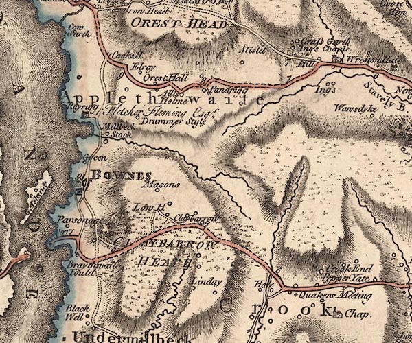 J5SD49NW.jpg "Parsonage" circle, labelled in italic lowercase text; settlement, farm, house, or hamlet? item:- National Library of Scotland : EME.s.47 Image © National Library of Scotland |
|
|
|
||
| evidence:- | old map:- Crosthwaite 1783-94 (Win/Ble) placename:- Parsonage |
|
| source data:- | Map, uncoloured engraving, An Accurate Map of the Grand Lake of
Windermere, scale about 2 inches to 1 mile, by Peter
Crosthwaite, Keswick, Cumberland, 1783, version published 1819. CT9SD39Y.jpg "Parsonage" block, building/s item:- Armitt Library : 2008.14.102 Image © see bottom of page |
|
|
|
||
| evidence:- | old map:- Clarke 1787 map (Windermere N) placename:- Vicarage |
|
| source data:- | Map, A Map of the Northern Part of the Lake Winandermere and its
Environs, scale about 6.5 ins to 1 mile, by James Clarke,
engraved by Samuel John Neele, 352 Strand, published by James
Clarke, Penrith, Cumberland and in London etc, 1787. CLASD49D.jpg "Vicarage" item:- private collection : 10.10 Image © see bottom of page |
|
|
|
||
| evidence:- | old text:- Martineau 1855 item:- porch |
|
| source data:- | Guide book, A Complete Guide to the English Lakes, by Harriet
Martineau, published by John Garnett, Windermere, Westmorland,
and by Whittaker and Co, London, 1855; published 1855-76. goto source goto sourcePage 11:- "... The rectory [Bowness-on-Windermere], which is hardly less venerable than the church, stands at a considerable distance from the village, and is approached through fields and a garden. The old-fashioned porch is there, of which this is said to be the last remaining instance in the whole district,- the roomy, substantial porch, with benches on each side, long enough to hold a little company of parishioners, and a round ivy-clad chimney immediately surmounting the porch. Within, there is abundant space, with little elevation;- plenty of room in the hall and parlours, with ceilings that one can touch with the hand." |
|
|
|
||
| evidence:- | old map:- Prior 1874 map 1 placename:- Rectory |
|
| source data:- | Map, uncoloured engraving or lithograph? Winander Mere, scale
about 2.5 miles to 1 inch, published by John Garnett,
Windermere, Westmorland, 1874. click to enlarge click to enlargePI03M1.jpg "Rectory" block/s; building/s item:- private collection : 133.1 Image © see bottom of page |
|
|
|
||
| evidence:- | database:- Listed Buildings 2010 placename:- Rectory |
|
| source data:- | courtesy of English Heritage "RECTORY (ST MARTIN'S) / / GLEBE ROAD / WINDERMERE TOWN / SOUTH LAKELAND / CUMBRIA / II[star] / 351674 / SD3990896210" |
|
|
|
||
| evidence:- | perhaps old print:- Atkinson 1847 (5th edn 1850) placename:- Parsonage House |
|
| source data:- | Print, woodcut engraving, The Parsonage House, Bowness, Westmorland, by T W Holme,
published by Thomas Atkinson, Kendal, Westmorland, 1850.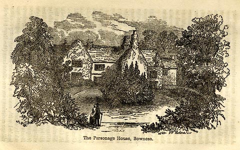 click to enlarge click to enlargeAK2E03.jpg On p.10 of a Handbook to the English Lakes, 5th edn. printed at bottom right, centre:- "TWHolme / Parsonage House, Bowness." item:- Armitt Library : A1144.4 Image © see bottom of page |
|
|
|
||
Lakes Guides menu.