 Old Cumbria Gazetteer
 |
 |
|
| Penrith Beacon, Penrith | ||
| Penrith Beacon | ||
| Beacon Tower | ||
| site name:- | Beacon Hill | |
| locality:- | Penrith | |
| civil parish:- | Penrith (formerly Cumberland) | |
| county:- | Cumbria | |
| locality type:- | hill | |
| locality type:- | beacon | |
| locality type:- | viewpoint | |
| coordinates:- | NY52123138 | |
| 1Km square:- | NY5231 | |
| 10Km square:- | NY53 | |
|
|
||
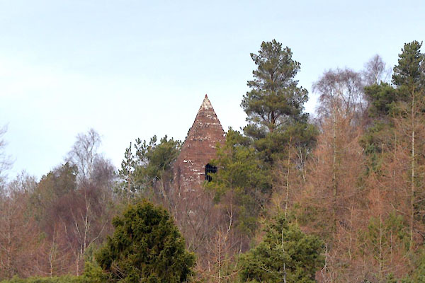 CHB41.jpg (taken 13.3.2018) 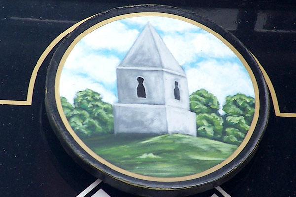 BMC43.jpg Depicted on the innsign of the Board and Elbow, Penrith. (taken 12.5.2006) |
||
|
|
||
| evidence:- | old map:- Saxton 1579 |
|
| source data:- | Map, hand coloured engraving, Westmorlandiae et Cumberlandiae Comitatus ie Westmorland
and Cumberland, scale about 5 miles to 1 inch, by Christopher Saxton, London, engraved
by Augustinus Ryther, 1576, published 1579-1645. Sax9NY53.jpg Tower on hillock. item:- private collection : 2 Image © see bottom of page |
|
|
|
||
| evidence:- | old map:- Speed 1611 (Wmd) |
|
| source data:- | Map, hand coloured engraving, The Countie Westmorland and
Kendale the Cheif Towne, scale about 2.5 miles to 1 inch, by
John Speed, 1610, published by George Humble, Popes Head Alley,
London, 1611-12. SP14NY53.jpg tower on a hillock item:- Armitt Library : 2008.14.5 Image © see bottom of page |
|
|
|
||
| evidence:- | old map:- Morden 1695 (Cmd) |
|
| source data:- | Map, uncoloured engraving, Cumberland, scale about 4 miles to 1
inch, by Robert Morden, 1695, published by Abel Swale, the
Unicorn, St Paul's Churchyard, Awnsham, and John Churchill, the
Black Swan, Paternoster Row, London, 1695-1715.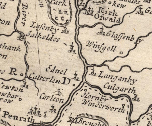 MD12NY53.jpg Small tower on a hillock. item:- JandMN : 90 Image © see bottom of page |
|
|
|
||
| evidence:- | old map:- Morden 1695 (Wmd) placename:- Penrith Beacon |
|
| source data:- | Map, hand coloured engraving, Westmorland, scale about 2.5 miles to 1 inch, by Robert
Morden, published by Abel Swale, the Unicorn, St Paul's Churchyard, Awnsham, and John
Churchill, the Black Swan, Paternoster Row, London, 1695.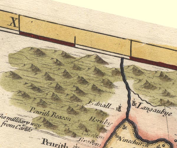 MD10NY53.jpg "Penrith Beacon" On a hillock, post, ladder and cresset?. item:- JandMN : 24 Image © see bottom of page |
|
|
|
||
| evidence:- | old text:- Gents Mag item:- rebellion, 1745; 1745 Rebellion |
|
| source data:- | Magazine, The Gentleman's Magazine or Monthly Intelligencer or
Historical Chronicle, published by Edward Cave under the
pseudonym Sylvanus Urban, and by other publishers, London,
monthly from 1731 to 1922. goto source goto sourceGentleman's Magazine 1746 p.62 "..." "Dec. 14 [1745]. The D. of Perth with about 110 men, the vanguard of the rebels, ... intending for Penrith that night, but perceiving that beacon on fire, they enquir'd at a public house [in Eamont Bridge] the reason; the landlady told them it was to raise the country, and added, 'Gentlemen, I desire you for God's sake to go back, because all the hedges from here to Penrith are lin'd.' They follow'd her advice, and returned to Shap. ..." |
|
|
|
||
| evidence:- | old text:- Gents Mag 1746 item:- rebellion, 1745; 1745 Rebellion |
|
| source data:- | goto source Gentleman's Magazine 1746 p.301 "... [1745 Rebellion]" "Penrith beacon was fir'd as a signal of distress, and the whole country thereupon flock'd southward to its relief. A party of about 120 rebels, which had been driven from Kendal before the rest came up, were intercepted in their flight, and pursued into Orton craigs; ..." |
|
|
|
||
| evidence:- | old text:- Morgan 1759 placename:- Cumberland |
|
| source data:- | MG02q011.txt "About a mile to the northward of Penrith, stands the Beacon, the fine prospects from which will amply repay the traveller the trouble of ascending it. It is a square stone building, and happily situated for alarming the country in times of public danger, as it commands an extensive vale. The northern window of the Beacon affords a prospect of Cross Fell, with the pikes of Dufton, together with a chain of mountains extending, from east to west, near thirty miles, the western point sinking in the spacious plain where the city of Carlisle lies. The utmost bounds of this view are formed by a ridge of Scotch mountains. The eastern window presents a view bounded by the hills of Stanmore, and that lofty promontory Wilbore Fell, with its neighbouring mountains above Kirby Stephen. The south window presents a view of Broughton Castle; and the spreading woods of Lowther, intermixed with rich cultivated lands, from the rising grounds. Some parts of the lake of" MG02q012.txt "Uls-water are seen from hence, while the mighty rocks and mountains which hem in the lake, lift up their heads in rude confusion, and crown the scene. The western window affords a new and not less pleasing prospect. The town of Penrith lies beneath it, and here and there the river Emont shows its windings through the woods. The hill, which rises above the town, is crowned with the aweful remains of a royal fortress: time has despoiled its grandeur, but its honours still survive to its noble owner the Duke of Portland, who therewith holds the honour of Penrith, formerly a royal franchise. Beyond these objects, amidst a range of mountains, at the distance of eighteen miles, Skiddow is seen, whose majestic front surmounts all the high lands that terminate the view. The whole prospect from the Beacon hill, as you turn every way, presents a vast theatre, upwards of one hundred miles in circumference, encircled with stupendous mountains." |
|
|
|
||
| evidence:- | old map:- Jefferys 1770 (Wmd) placename:- Penrith Beacon |
|
| source data:- | Map, 4 sheets, The County of Westmoreland, scale 1 inch to 1
mile, surveyed 1768, and engraved and published by Thomas
Jefferys, London, 1770.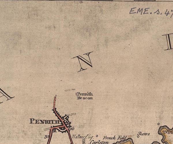 J5NY53SW.jpg "Penrith Beacon" tower item:- National Library of Scotland : EME.s.47 Image © National Library of Scotland |
|
|
|
||
| evidence:- | old map:- Donald 1774 (Cmd) placename:- Penrith Beacon |
|
| source data:- | Map, hand coloured engraving, 3x2 sheets, The County of Cumberland, scale about 1
inch to 1 mile, by Thomas Donald, engraved and published by Joseph Hodskinson, 29
Arundel Street, Strand, London, 1774.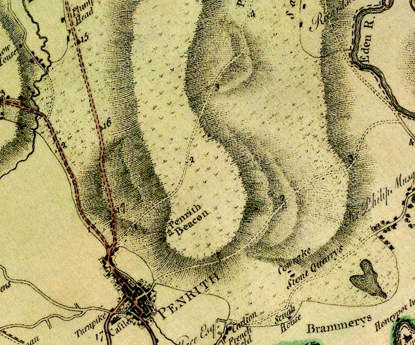 D4NY53SW.jpg "Penrith Beacon" tower item:- Carlisle Library : Map 2 Image © Carlisle Library |
|
|
|
||
| evidence:- | old text:- Gilpin 1786 item:- war; border reiver; outlaw |
|
| source data:- | Book, Observations, Relative Chiefly to Picturesque Beauty, Made
in the Year 1772, on Several Parts of England, Particularly the
Mountains, and Lakes of Cumberland Westmoreland, by Rev William
Gilpin, 1772-74; published 1786-1808. goto source vol.2 p.85 "In the offskip, beyond the castle, arose a hill, in shadow likewise; on the top of which stood a lonely beacon. The windows answering each other, we could just discern the glowing horizon through them - a circumstance, which however trivial in description, has a beautiful effect in landscape." "The beacon is a monument of those tumultuous times, which preceded the union; and the only monument of the kind now remaining in these parts; though such beacons were stationed over the whole country;" goto sourcevol.2 p.86 "and could spread intelligence, in a few seconds, from one end of it to the other." "At this later day these castles and posts of alarm, adorning the country, they once defended, raise pleasing reflections on a comparison of present times with the past - those turbulent times, when no man could sleep in safety unless secured by a fortress. In war he feared the invasion of an open enemy: and in peace a mischief still more formidable, the ravages of banditti; with whom the country was always at that time infested. These wretches were composed of the outlaws from both nations; and inhabiting the fastnesses of the bogs, and mountains, used to sally out, and plunder in all directions." "..." |
|
|
|
||
| evidence:- | old text:- Clarke 1787 |
|
| source data:- | Guide book, A Survey of the Lakes of Cumberland, Westmorland,
and Lancashire, written and published by James Clarke, Penrith,
Cumberland, and in London etc, 1787; published 1787-93. goto source Page 22:- "..." "... this places [Bishop's Flatts] serves to stop, and breath a little, before we ascend the steep hill on which the beacon stands. The journey is laborious, though a fine green path renders it more pleasing; but when we arrive at the beacon, the beautiful and extensive prospect makes ample amends for all difficulties. If the day be clear, you see Cumberland spread like an immense map under you. Nor is your view limited to that alone, Criffell, Cheviot, and Queensbery-Hill in Scotland, are visible towards the N.E. though 80 miles distant. On the South, the mountains from Stainmoor in Westmorland, to Ingleborough in Yorkshire, rise in various tints of blue and purple. In the West, Helveylin and St Sunday's Cragg rear their rugged heads, whilst Ulswater is seen extended like an azure mirror at their feet; and towards the East, that immense ridge of mountains called Cross-Fell, extends itself no less than 30 miles in length; which, when covered with its Helm, exhibits a surprising and singular spectacle. From hence likewise may be distinctly seen, even with the naked eye, (provided the day be clear,) Carlisle, the white house at Gretna Green and Solway Firth; whilst all the nearer parts of the country offer themselves to the eye, so beautifully bespotted with villages, woods, heaths, forests, ruins, and elegant seats, that it must be seen, and not described, in order to convey away an idea of the grandeur of this prospect. To assist my reader as much as possible, I have, in the annexed Plate, drawn lines of direction to the several objects; let him therefore find one of them, (Ulswater, for instance,) and lay the Plan with the proper line of direction pointing to it; the Plan will then explain the country round, much better than the generality of guides will be able to do." |
|
|
|
||
| evidence:- | old print:- Clarke 1787 placename:- Penrith Beacon item:- topograph |
|
| source data:- | topograph view centred on Helvellyn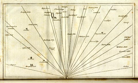 click to enlarge click to enlargeCL18.jpg "Penrith Beacon" item:- Armitt Library : A6615.12 Image © see bottom of page |
|
|
|
||
| evidence:- | old print:- Clarke 1787 placename:- Penrith Beacon item:- topograph |
|
| source data:- | the beacon is illustrated on the print, but lost in the spine of the book - so here's
a photograph of it.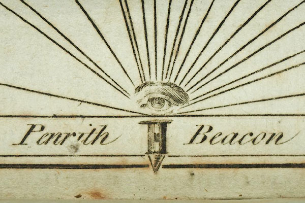 CL18Vgn1.jpg "Penrith Beacon" item:- Armitt Library : A6615.12 Image © see bottom of page |
|
|
|
||
| evidence:- | descriptive text:- Baker 1802 placename:- Beacon, The |
|
| source data:- | Perspective road map with sections in Lancashire, Westmorland,
and Cumberland, by J Baker, London 1802. pp.25-26:- "..." "Penrith is situated beneath some verdurous heights that stretch from it towards the east; one point of which is decorated with a fancy building, commonly called the Beacon. From this spot is a most interesting view if the adjacent country, and hereon are the annual races of the town. ..." |
|
|
|
||
| evidence:- | old map:- Baker 1802 |
|
| source data:- | Perspective road maps with sections in Lancashire, Westmorland
and Cumberland, by J Baker, London 1802.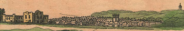 Bk03Vg04.jpg item:- private collection : 3 Image © see bottom of page |
|
|
|
||
| evidence:- | descriptive text:- Otley 1823 (5th edn 1834) |
|
| source data:- | Guide book, A Concise Description of the English Lakes, the
mountains in their vicinity, and the roads by which they may be
visited, with remarks on the mineralogy and geology of the
district, by Jonathan Otley, published by the author, Keswick,
Cumberland now Cumbria, by J Richardson, London, and by Arthur
Foster, Kirkby Lonsdale, Cumbria, 1823; published 1823-49,
latterly as the Descriptive Guide to the English Lakes. goto source Page 83:- "... The Beacon, standing in the centre of a large plantation on Penrith fell, is a more modern erection of hewn stone, and commands extensive views of the country. ..." |
|
|
|
||
| evidence:- | descriptive text:- Ford 1839 (3rd edn 1843) placename:- Beacon, The |
|
| source data:- | Guide book, A Description of Scenery in the Lake District, by
Rev William Ford, published by Charles Thurnam, Carlisle, by W
Edwards, 12 Ave Maria Lane, Charles Tilt, Fleet Street, William
Smith, 113 Fleet Street, London, by Currie and Bowman,
Newcastle, by Bancks and Co, Manchester, by Oliver and Boyd,
Edinburgh, and by Sinclair, Dumfries, 1839. goto source Page 132:- "..." "... Above the race-course, on the point of a wood-embowered hill, stands the Beacon, which the traveller may visit for the purpose of seeing from a moderate elevation the country lying around, and thus forming a correct idea of the relative situation of places of interest. ..." |
|
|
|
||
| evidence:- | old map:- Ford 1839 map |
|
| source data:- | Map, uncoloured engraving, Map of the Lake District of
Cumberland, Westmoreland and Lancashire, scale about 3.5 miles
to 1 inch, published by Charles Thurnam, Carlisle, and by R
Groombridge, 5 Paternoster Row, London, 3rd edn 1843.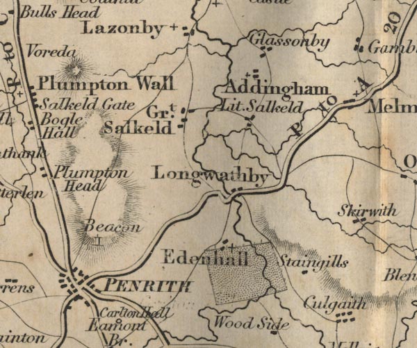 FD02NY53.jpg "Beacon" Tower, on the hill N of Penrith. item:- JandMN : 100.1 Image © see bottom of page |
|
|
|
||
| evidence:- | database:- Listed Buildings 2010 placename:- Beacon Tower |
|
| source data:- | courtesy of English Heritage "BEACON TOWER / / BEACON ROAD / PENRITH / EDEN / CUMBRIA / I / 72779 / NY5212931377" |
|
| source data:- | courtesy of English Heritage "1719 on site of earlier beacons. Repaired 1780, red sandstone, low square tower with pyramid stone roof. Round-arched opening each side with keystones and wrought iron grilles, and small loops to north and south. Round-headed doorway on east. On top of hill, about 930 ft elevation, very prominent landmark." |
|
|
|
||
| evidence:- | old print:- Robertson 1911 placename:- Penrith Beacon |
|
| source data:- | Print, lithograph? Yanwath Hall, Penrith, and Penrith Beacon, from a watercolour by
Arthur Tucker, published by Chatto and Windus, London, 1911.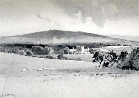 click to enlarge click to enlargeRSN104.jpg Tipped in opposite p.12 of Wordsworthshire by Eric Robertson. printed at bottom:- "YANWATH, PENRITH, AND PENRITH BEACON / (seen from Sockbridge)" signed at painting lower left:- "Arthur Tucker" item:- JandMN : 197.4 Image © see bottom of page |
|
|
|
||
| hearsay:- |
The beacon was lit, falsely, to warn of a Napoleonic invasion, 1805. Sir Walter Scott,
who was touring he Lakes, immediately returned to his regiment in Dalkeith at this
scare. |
|
|
|
||
Lakes Guides menu.