 Old Cumbria Gazetteer
 |
 |
|
| Peel O'Hill, Bewcastle | ||
| Peel O'Hill | ||
| Pele-o-Hill | ||
| locality:- | Pelaw Hill | |
| civil parish:- | Bewcastle (formerly Cumberland) | |
| county:- | Cumbria | |
| locality type:- | buildings | |
| coordinates:- | NY55897531 | |
| 1Km square:- | NY5575 | |
| 10Km square:- | NY57 | |
|
|
||
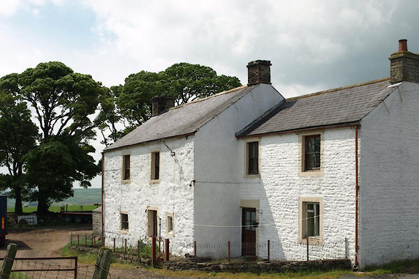 BWQ34.jpg (taken 1.6.2012) |
||
|
|
||
| evidence:- | old map:- OS County Series (Cmd 8 2) placename:- Peel o' Hill |
|
| source data:- | Maps, County Series maps of Great Britain, scales 6 and 25
inches to 1 mile, published by the Ordnance Survey, Southampton,
Hampshire, from about 1863 to 1948. |
|
|
|
||
| evidence:- | old map:- Donald 1774 (Cmd) placename:- Pela Hill |
|
| source data:- | Map, hand coloured engraving, 3x2 sheets, The County of Cumberland, scale about 1
inch to 1 mile, by Thomas Donald, engraved and published by Joseph Hodskinson, 29
Arundel Street, Strand, London, 1774.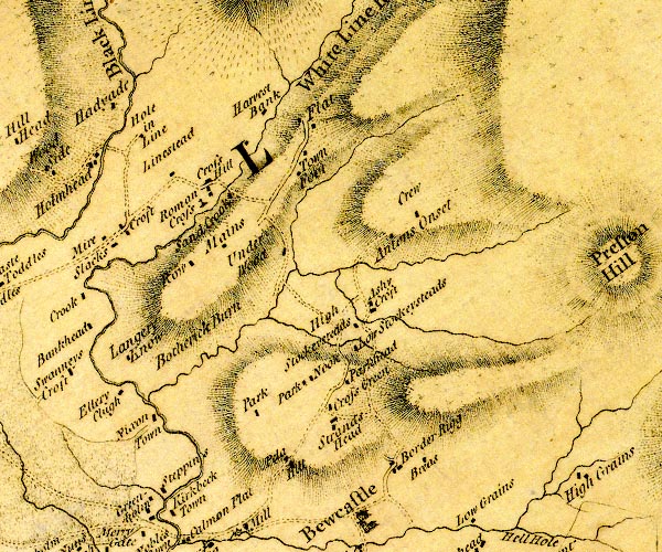 D4NY57NE.jpg "Pela Hill" block or blocks, labelled in lowercase; a hamlet or just a house item:- Carlisle Library : Map 2 Image © Carlisle Library |
|
|
|
||
| evidence:- | old text:- Gents Mag |
|
| source data:- | Magazine, The Gentleman's Magazine or Monthly Intelligencer or
Historical Chronicle, published by Edward Cave under the
pseudonym Sylvanus Urban, and by other publishers, London,
monthly from 1731 to 1922. goto source goto sourceGentleman's Magazine 1852 part 1 p.481 "..." "ROMAN WAY-SIDE WATCH-TOWER AT BEWCASTLE. - The station at Bewcastle is placed upon a slightly elevated platform at the bottom of a valley through which the small river Kirkbeck flows. There can be little doubt that it was planted here to guard the Maiden Way, which crosses the valley on its path to the Scottish border. As the station is situated in the low ground, the prospect is very limited towards both north and south. The hill to the north of the station" |
|
|
|
||
| evidence:- | old text:- Gents Mag 1852 placename:- Pelaw Hill |
|
| source data:- | goto source Gentleman's Magazine 1852 part 1 p.482 "is called Pelaw Hill. Here stands a farm-house, which was formerly a border fortress or peel. We may readily suppose that in Roman times it was the site of a look-out or beacon-tower connected with the station." |
|
|
|
||
| evidence:- | site plan:- Curwen 1913 placename:- Peel O'Hill |
|
| source data:- | Site plan, lithograph, Peel O'Hill, Bewcastle, Cumberland, published for the Cumberland
and Westmorland Antiquarian and Archaeological Society by Titus Wilson, Kendal, Westmorland,
1913.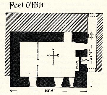 click to enlarge click to enlargeCW0179.jpg On p.388 of The Castles and Fortified Towers of Cumberland, Westmorland, and Lancashire North of the Sands, by John F Curwen. printed at top:- "Peel O'Hill" item:- Armitt Library : A782.79 Image © see bottom of page |
|
|
|
||
| evidence:- | database:- Listed Buildings 2010 placename:- Peel O'Hill item:- date stone (1811) |
|
| source data:- | courtesy of English Heritage "PEEL O'HILL / / / BEWCASTLE / CARLISLE / CUMBRIA / II / 78122 / NY5589275302" |
|
|
|
||
| hearsay:- |
There is the ruin of a bastle house here. Some call it a pele tower, and call the
hill Pele-o-Hill. |
|
|
|
||
| notes:- |
house converted from a bastle |
|
| Perriam, D R &Robinson, J: 1998: Medieval Fortified Buildings of Cumbria: CWAAS::
ISBN 1 873124 23 6; plan and illustration |
||
|
|
||
Lakes Guides menu.