 Old Cumbria Gazetteer
 |
 |
|
| Pedderhill, Arthuret | ||
| Pedderhill | ||
| civil parish:- | Arthuret (formerly Cumberland) | |
| county:- | Cumbria | |
| locality type:- | buildings | |
| coordinates:- | NY42787333 | |
| 1Km square:- | NY4273 | |
| 10Km square:- | NY47 | |
|
|
||
| evidence:- | old map:- Donald 1774 (Cmd) |
|
| source data:- | Map, hand coloured engraving, 3x2 sheets, The County of Cumberland, scale about 1
inch to 1 mile, by Thomas Donald, engraved and published by Joseph Hodskinson, 29
Arundel Street, Strand, London, 1774.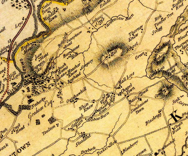 D4NY47SW.jpg "Ped[l ] Hill" block or blocks, labelled in lowercase; a hamlet or just a house item:- Carlisle Library : Map 2 Image © Carlisle Library |
|
|
|
||
| evidence:- | old map:- Post Office 1850s-1900s placename:- Pedder Hill |
|
| source data:- | Post road maps, General Post Office Circulation Map for England
and Wales, for the General Post Office, London, 1850s-1900s. click to enlarge click to enlargePOF7Cm.jpg "Pedder Hill" map date 1909 |
|
|
|
||
| :- |
images courtesy of the British Postal Museum and Hampshire CC Museums |
|
|
|
||
| personal | ||
| person:- | artist : Carruthers, Richard |
|
| place:- | birthplace | |
|
|
||
 Lakes Guides menu.