 Old Cumbria Gazetteer
 |
 |
|
| Park Nook, Waberthwaite | ||
| Park Nook | ||
| civil parish:- | Waberthwaite (formerly Cumberland) | |
| county:- | Cumbria | |
| locality type:- | buildings | |
| coordinates:- | SD10669301 | |
| 1Km square:- | SD1093 | |
| 10Km square:- | SD19 | |
|
|
||
| evidence:- | old map:- OS County Series (Cmd 85 4) placename:- Park Nook |
|
| source data:- | Maps, County Series maps of Great Britain, scales 6 and 25
inches to 1 mile, published by the Ordnance Survey, Southampton,
Hampshire, from about 1863 to 1948. |
|
|
|
||
| evidence:- | old map:- Donald 1774 (Cmd) placename:- Park Nook |
|
| source data:- | Map, hand coloured engraving, 3x2 sheets, The County of Cumberland, scale about 1
inch to 1 mile, by Thomas Donald, engraved and published by Joseph Hodskinson, 29
Arundel Street, Strand, London, 1774.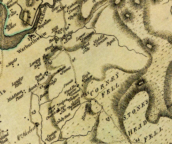 D4SD19SW.jpg "Park Nook" block or blocks, labelled in lowercase; a hamlet or just a house item:- Carlisle Library : Map 2 Image © Carlisle Library |
|
|
|
||
| evidence:- | old map:- Laurie and Whittle 1806 placename:- Park Nook |
|
| source data:- | Road map, Completion of the Roads to the Lakes, scale about 10
miles to 1 inch, by Nathaniel Coltman? 1806, published by Robert
H Laurie, 53 Fleet Street, London, 1834. click to enlarge click to enlargeLw18.jpg "Park Nook 293½" village or other place; distance from London item:- private collection : 18.18 Image © see bottom of page |
|
|
|
||
 Lakes Guides menu.