 Old Cumbria Gazetteer
 |
 |
|
| Oldchurch, Matterdale | ||
| Oldchurch | ||
| civil parish:- | Matterdale (formerly Cumberland) | |
| county:- | Cumbria | |
| locality type:- | buildings | |
| locality type:- | church (site of) | |
| coordinates:- | NY44212116 | |
| 1Km square:- | NY4421 | |
| 10Km square:- | NY42 | |
|
|
||
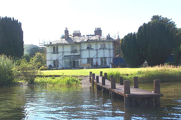 BNZ92.jpg (taken 24.8.2007) |
||
|
|
||
| evidence:- | old map:- OS County Series (Cmd 66 9) placename:- Oldchurch |
|
| source data:- | Maps, County Series maps of Great Britain, scales 6 and 25
inches to 1 mile, published by the Ordnance Survey, Southampton,
Hampshire, from about 1863 to 1948. |
|
|
|
||
| evidence:- | old map:- Crosthwaite 1783-94 (Ull) placename:- Old Church |
|
| source data:- | Map, uncoloured engraving, Accurate Map of the Beautiful Lake of
Ullswater, scale about 3 inches to 1 mile, by Peter Crosthwaite,
Keswick, Cumberland, 1783, version published 1800.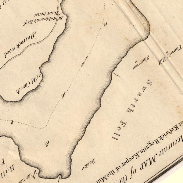 CT5NY42K.jpg "Old Church" item:- Armitt Library : 1959.191.7 Image © see bottom of page |
|
|
|
||
| evidence:- | old text:- Clarke 1787 placename:- Old Church |
|
| source data:- | Guide book, A Survey of the Lakes of Cumberland, Westmorland,
and Lancashire, written and published by James Clarke, Penrith,
Cumberland, and in London etc, 1787; published 1787-93. goto source goto sourcePage 26:- "..." "About a mile further up is Old Church, so called from a church or chapel formerly situated there: This seems to have been pretty large, for the present house stands upon part of the ruins of an old building. It is said, but I think without reason, to have been standing in the reign of Edward the III. I am in possession of an admission of Anthony Rumney as tenant of two tenements at Gowbarrow-Hall, and part of a tenement at Old Church: this admission farther sets forth, that the parochial chapel and the burying-ground was then at Gowbarrow-Hall; and as it is dated in 1474, we must naturally conclude that the destruction of the church at this hamlet must have long preceded the reign of Edward the III." |
|
|
|
||
| evidence:- | old map:- Clarke 1787 map (Ullswater) placename:- Old Church |
|
| source data:- | Map, A Map of the Lake Ullswater and its Environs, scale about
6.5 ins to 1 mile, by James Clarke, engraved by S J Neele, 352
Strand, published by James Clarke, Penrith, Cumberland and in
London etc, 1787.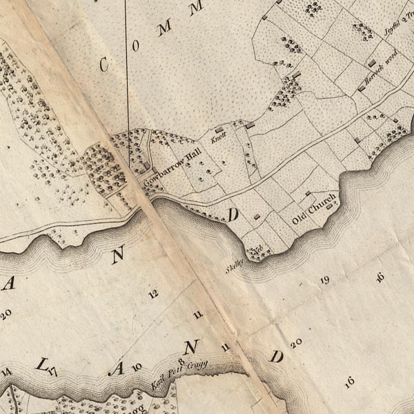 CL4NY42F.jpg "Old Church" item:- private collection : 10.4 Image © see bottom of page |
|
|
|
||
| evidence:- | old text:- Wordsworth 1810 item:- yew tree |
|
| source data:- | Guide book, A Description of the Scenery of the Lakes, later A
Guide through the District of The Lakes, by William Wordsworth,
1810-35. goto source page xviii "... The Church-yard Yew-tree still survives at Old Church, but there are no remains of a Place of Worship, ..." |
|
|
|
||
| evidence:- | possibly descriptive text:- Ford 1839 (3rd edn 1843) item:- yew; tree |
|
| source data:- | Guide book, A Description of Scenery in the Lake District, by
Rev William Ford, published by Charles Thurnam, Carlisle, by W
Edwards, 12 Ave Maria Lane, Charles Tilt, Fleet Street, William
Smith, 113 Fleet Street, London, by Currie and Bowman,
Newcastle, by Bancks and Co, Manchester, by Oliver and Boyd,
Edinburgh, and by Sinclair, Dumfries, 1839. goto source Page 145:- "..." "... Near the pleasant village of Watermillock, stood the old church, in a very sequestered bay; the old church-yard yew-tree still survives. ..." |
|
|
|
||
| hearsay:- |
The building was the Old Church Hotel at one time? |
|
|
|
||
Lakes Guides menu.