 Old Cumbria Gazetteer
 |
 |
|
| Nab Gill Mine, Eskdale | ||
| Nab Gill Mine | ||
| Eskdale Iron Mines | ||
| Whitehaven Iron Mine | ||
| site name:- | Eskdale Valley | |
| civil parish:- | Eskdale (formerly Cumberland) | |
| county:- | Cumbria | |
| locality type:- | iron mine | |
| locality type:- | mine | |
| coordinates:- | NY17360134 (etc) | |
| 1Km square:- | NY1701 | |
| 10Km square:- | NY10 | |
| references:- | Adams, John: 1988: Mines of the Lake District Fells: Dalesman Books (Lancaster, Lancashire)::
ISBN 0 85206 931 6 |
|
|
|
||
| evidence:- | old text:- Postlethwaite 1877 (3rd edn 1913) placename:- Whitehaven Iron Mine placename:- Nab Gill Mine item:- iron ore; haematite |
|
| source data:- | Book, Mines and Mining in the English Lake District, by John Postlethwaite, Keswick,
published by W H Moss and Sons, Whitehaven, Cumberland now Cumbria, 1877; published
1877-1913. goto source goto sourcepage 138:- "In the Eskdale Granite there are a great number of veins of haematite iron, some of which have yielded a good deal of ore, and the grass-covered mounds in Red Gill, on the southern side of Eskdale Valley, prove that some of them were worked in early times. About 42 years ago, the Whitehaven Iron Mine, or Nab Gill Mine, as it is commonly called, was opened; it is situated on the northern side of the valley, close to the village of Boot. The bearing of the vein is north-west and south-east, and its hade is towards the north-east. Six levels have been driven into the mountain, at various elevations, the lowest being about 110 fathoms below the highest point where ore has been worked out to the surface. A number of small deposits of ore were stoped in levels Nos. 4 and 5, but they were not driven so far as the point where the best deposits were found in the levels above. These deposits in the upper levels were of considerable extent, and some of them were worked out to the surface." |
|
|
|
||
| evidence:- | old map:- Postlethwaite 1877 (3rd edn 1913) placename:- Nab Gill Mine |
|
| source data:- | Map, uncoloured engraving, Map of the Lake District Mining Field, Westmorland, Cumberland,
Lancashire, scale about 5 miles to 1 inch, by John Postlethwaite, published by W H
Moss and Sons, 13 Lowther Street, Whitehaven, Cumberland, 1877 edn 1913.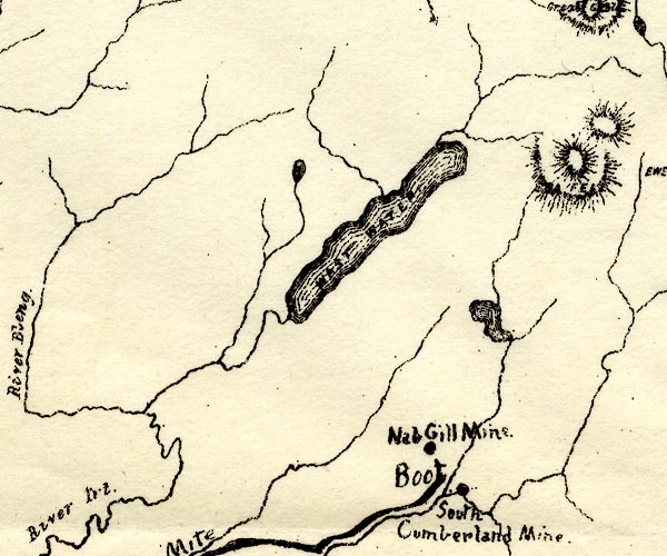 PST2NY10.jpg "Nab Gill Mine" mine symbol item:- JandMN : 162.2 Image © see bottom of page |
|
|
|
||
| :- |
Begun in 1840s; abandoned 1880s; reopened 1900s-10s. |
|
| Partly the Mitredale Side Vein. |
||
| Adams, John: 1988: Mines of the Lake District Fells: Dalesman Books (Lancaster, Lancashire)::
ISBN 0 85206 931 6 |
||
|
|
||
Lakes Guides menu.