 Old Cumbria Gazetteer
 |
 |
|
| Mud Foot Hole, North Yorkshire | ||
| Mud Foot Hole | ||
| county:- | North Yorkshire | |
| locality type:- | pothole | |
| locality type:- | cave | |
| coordinates:- | SD728726 (?) | |
| 1Km square:- | SD7272 | |
| 10Km square:- | SD77 | |
| references:- | Balderston c1890 |
|
|
|
||
| evidence:- | descriptive text:- Balderston c1890 placename:- Mud Foot Hole |
|
| source data:- | Book, Ingleton, Bygone and Present, by Robert R and Margaret
Balderston, published by Simpkin, Marshall and Co, London, and
by Edmndson and Co, 24 High Street, Skipton, Yorkshire, about
1890. goto source goto sourcepage 45:- "..." "Mud-foot Hole." "On Dowlass Moss, to the south-east of Crina Bottom, and about half a mile from that place, is another hole with" goto sourcepage 46:- "two apertures and some chinks at one end. This rift has the appearance of being connected with a deep chasm, but a steep bank of mud some distance down arrests the descent of the plummet or stones thrown in to test the depth. Measured from above the three orifices are found to be respectively forty-five, forty-seven, and forty-five feet deep." |
|
|
|
||
| evidence:- | old map:- Balderston c1890 map placename:- Mud Foot Hole |
|
| source data:- | Map, the hills in the Ingleton area, probably by Robert R
Balderston, engraved by Goodall and Suddick, Leeds, West
Yorkshire, about 1890.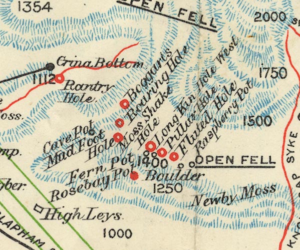 BS1SD77G.jpg "Mud Foot Hole" item:- private collection : 27.1 Image © see bottom of page |
|
|
|
||
Lakes Guides menu.