 Old Cumbria Gazetteer
 |
 |
|
| milestone, Whitwell and Selside (4) | ||
| site name:- | road, Kendal to Shap | |
| locality:- | Gateside | |
| civil parish:- | Whitwell and Selside (formerly Westmorland) | |
| county:- | Cumbria | |
| locality type:- | milestone | |
| coordinates:- | SD52859951 | |
| 1Km square:- | SD5299 | |
| 10Km square:- | SD59 | |
|
|
||
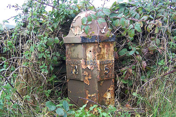 BJW33.jpg Cast iron. "SHAP 11 MILES / 1825 / KENDAL 5 MILES" (taken 29.9.2005) |
||
|
|
||
| evidence:- | old map:- OS County Series (Wmd 33 8) |
|
| source data:- | Maps, County Series maps of Great Britain, scales 6 and 25
inches to 1 mile, published by the Ordnance Survey, Southampton,
Hampshire, from about 1863 to 1948. "M.S. Shap .. 11 Kendal .. 5" "" |
|
|
|
||
| evidence:- | database:- Listed Buildings 2010 |
|
| source data:- | courtesy of English Heritage "MILEPOST TO WEST OF NORTH GATESIDE / / A6 / WHITWELL AND SELSIDE / SOUTH LAKELAND / CUMBRIA / II / 75766 / SD5285699512" |
|
| source data:- | courtesy of English Heritage "Milepost. Dated 1825. Cast iron. Half-hexagonal with concave faces and domed cap. Lettering on panels to sides reading; to left: "SHAP/11/MILES"; to right: "KENDAL/5/MILES"; date to centre. One of a series of mileposts on the Heron Syke to Eamont Bridge turnpike road, 1753." |
|
|
|
||
 Lakes Guides menu.