 Old Cumbria Gazetteer
 |
 |
|
| milestone, Firbank (6) | ||
| site name:- | road, Kirkby Lonsdale to Low Borrowbridge | |
| civil parish:- | Firbank (formerly Westmorland) | |
| county:- | Cumbria | |
| locality type:- | milestone | |
| coordinates:- | SD62899334 | |
| 1Km square:- | SD6293 | |
| 10Km square:- | SD69 | |
|
|
||
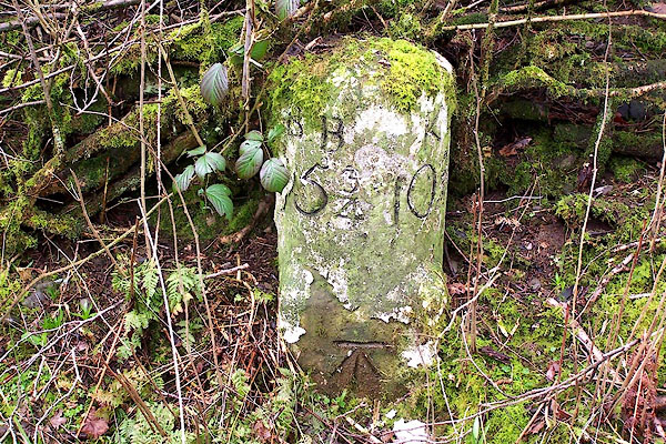 BLT20.jpg inscribed stone:- "B.B 5¾ K.L 10 [3]/4" ie Borrow Bridge and Kirkby Lonsdale (taken 31.3.2006) |
||
|
|
||
| evidence:- | old map:- OS County Series (Wmd 40 1) placename:- |
|
| source data:- | Maps, County Series maps of Great Britain, scales 6 and 25
inches to 1 mile, published by the Ordnance Survey, Southampton,
Hampshire, from about 1863 to 1948. "Burrowbridge .. 5 [3/4] Kirkby Lonsdale .. 10 3/4 M.S." |
|
|
|
||
| evidence:- | database:- Listed Buildings 2010 |
|
| source data:- | courtesy of English Heritage "MILESTONE AT SD 628 933 / / B6257 / FIRBANK / SOUTH LAKELAND / CUMBRIA / II / 75651 / SD6289293346" |
|
| source data:- | courtesy of English Heritage "Milepost. Early C19. Painted stone. Semicircular on plan, on square base with broaches to angles. Inscribed: "BB : KL/53/4 : 103/4" (BB = Borrow Bridge; KL = Kirkby Lonsdale). Benchmark to base. Placed on the Sedbergh to Grayrigg turnpike road, 1762." |
|
|
|
||
 Lakes Guides menu.