 Old Cumbria Gazetteer
 |
 |
|
| Middle Swinklebank, Longsleddale | ||
| Middle Swinklebank | ||
| locality:- | Swinklebank | |
| civil parish:- | Longsleddale (formerly Westmorland) | |
| county:- | Cumbria | |
| locality type:- | buildings | |
| coordinates:- | NY49450410 | |
| 1Km square:- | NY4904 | |
| 10Km square:- | NY40 | |
|
|
||
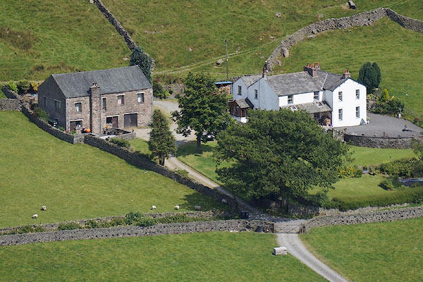 CBC49.jpg Swinklebank House and Saddler's Croft (taken 11.7.2014) |
||
|
|
||
| evidence:- | old map:- OS County Series (Wmd 27 11) placename:- Middle Swinklebank |
|
| source data:- | Maps, County Series maps of Great Britain, scales 6 and 25
inches to 1 mile, published by the Ordnance Survey, Southampton,
Hampshire, from about 1863 to 1948.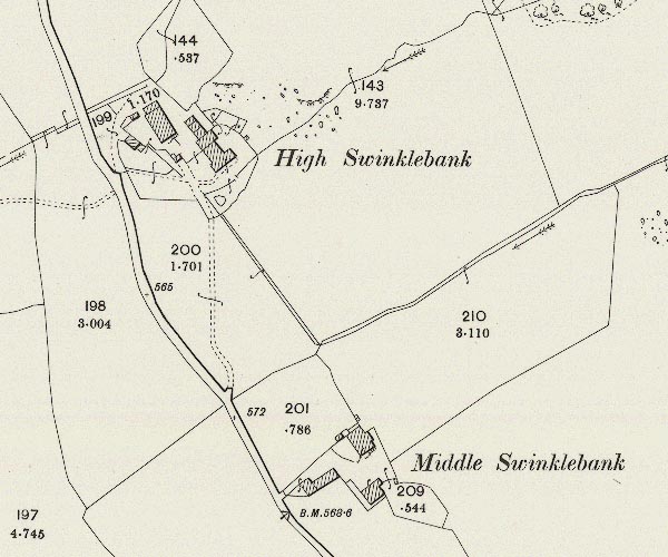 C5E009.jpg "Middle Swinklebank" |
|
|
|
||
| evidence:- | census returns:- placename:- Middle Swinklebank placename:- Middle Swinkle Bank |
|
|
|
||
| evidence:- | old map:- Jefferys 1770 (Wmd) placename:- Swinkle Bank |
|
| source data:- | Map, 4 sheets, The County of Westmoreland, scale 1 inch to 1
mile, surveyed 1768, and engraved and published by Thomas
Jefferys, London, 1770.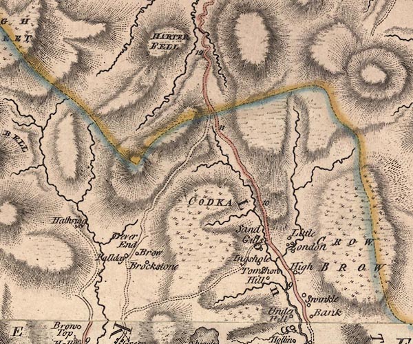 J5NY40NE.jpg "Swinkle Bank" circle, labelled in italic lowercase text; settlement, farm, house, or hamlet? item:- National Library of Scotland : EME.s.47 Image © National Library of Scotland |
|
|
|
||
| evidence:- | old map:- Kendal Corn Rent Act 1836 placename:- Middle Swindle Bank |
|
| source data:- | Tithe map, Plan of part of the Township of Longsleddale, Westmorland, made regarding
the Kendal Corn Rent Act, ie a tithe award map, scale about 20 inches to 1 mile, Kendal,
Westmorland, 1836.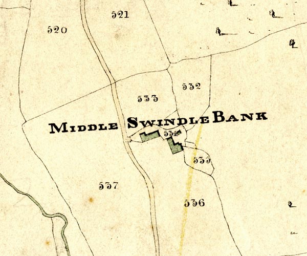 KCR209.jpg courtesy of Mark Cropper Plan of part of the Township of Longsleddale, Westmorland, made regarding the Kendal Corn Rent Act, ie a tithe award map, scale about 20 inches to 1 mile, Kendal, Westmorland, 1836. "MIDDLE SWINDLE BANK" item:- private collection : 370 Image © see bottom of page |
|
|
|
||
 Kendal Corn Rent Act 1836 Kendal Corn Rent Act 1836 |
||
|
|
||
| evidence:- | old map:- OS 1881-82 New Series (outline edition) placename:- Swinklebank |
|
| source data:- | Map, engraving, area north of Kendal, Westmorland, New Series
one inch map, outline edition, sheet 39, scale 1 inch to 1 mile,
published by the Ordnance Survey, Southampton, Hampshire,
1881-82.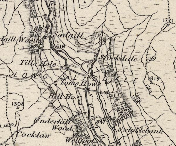 O21NY40X.jpg , "Swinklebank" item:- JandMN : 61 Image © see bottom of page |
|
|
|
||
| evidence:- | old map:- Thurnam 1920s placename:- |
|
| source data:- | Map, colour lithograph, Thurnam's Map of Carlisle and District,
scale about 2 miles to 1 inch, by .Gall and Inglis, edinburgh,
published by Charles Thurnam and Sons, Carlisle, Cumberland,
13th edn 1920s-30s?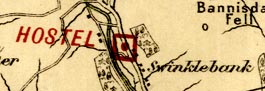 THM4Pce.jpg "Swinklebank" overprinted to show a "HOSTEL" item:- JandMN : 764 Image © see bottom of page |
|
|
|
||
| census records |
||
|
|
||
| directory entries |
||
|
|
||
| evidence:- | map:- OS Six Inch (1956) placename:- Middle Swinklebank |
|
| source data:- | Map series, various editions with the national grid, scale about
6 inches to 1 mile, published by the Ordnance Survey,
Southampton, Hampshire, scale 1 to 10560 from 1950s to 1960s,
then 1 to 10000 from 1960s to 2000s, superseded by print on
demand from digital data.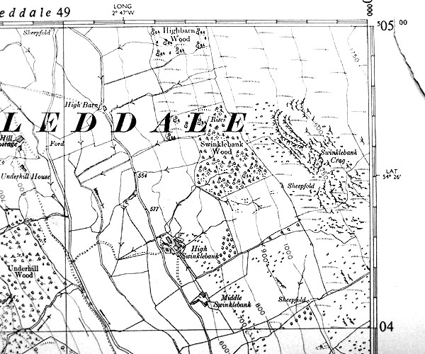 SINY4904.jpg "Middle Swinklebank" |
|
|
|
||
| evidence:- | shepherds guide:- Wilson 1913 placename:- Middle Swinkle Bank |
|
| source data:- | Book, New Shepherd's Guide for Cumberland, Westmorland, and
Lancashire, by Thomas Wilson, 1913.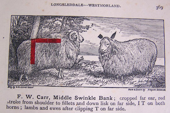 WL1p369a.jpg "F. W. Carr, Middle Swinkle Bank; cropped far ear, red stroke from shoulder to fillets and down lisk on far side, I T on both horns; lambs and ewes after clipping T on far side." item:- private collection : 329 Image © see bottom of page |
|
|
|
||
| evidence:- | shepherds guide:- Gate 1879 placename:- Middle Swingle Bank |
|
| source data:- | Book, New Shepherd's Guide for Cumberland, Westmoreland, and
Lancashire, published by Daniel Gate, Keswick, Cumberland, 1879.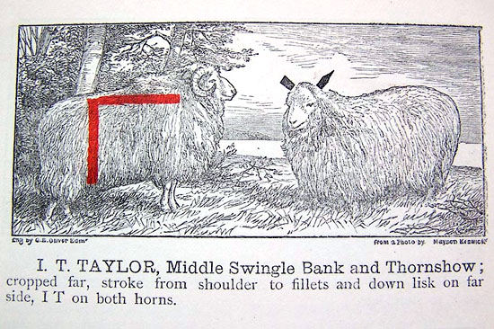 GT1p386a.jpg "I. T. TAYLOR, Middle Swingle Bank and Thornshow; croppped far, stroke from shoulder to fillets and down lisk on far side, IT on both horns." item:- Kendal Library : 38 Image © see bottom of page |
|
|
|
||
| evidence:- | shepherds guide:- Hodgson 1849 placename:- Middle Swingle Bank |
|
| source data:- | Book, Shepherd's Guide, or a Delineation of the Wool and Ear
Marks of the Different Stocks of Sheep, Lancashire, Cumberland,
and Westmorland, by William Hodgson, Normoss, Corney,
Cumberland, 1849.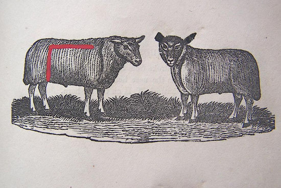 HG2p595a.jpg "HENRY MATTINSON, Middle Swingle Bank." "Cropped far ear, a red stroke from the shoulder blade to the lisk, and down the lisk on the far side, HM on the far horn." item:- Kendal Library : 39 Image © see bottom of page |
|
|
|
||
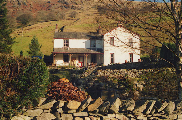 BIG36.jpg Swinklebank House, Middle Swinklebank. (taken 4.12.2003) |
||
|
|
||
 Lakes Guides menu.