 Old Cumbria Gazetteer
 |
 |
|
| Marble Pot, North Yorkshire | ||
| Marble Pot | ||
| county:- | North Yorkshire | |
| locality type:- | cave | |
| coordinates:- | SD759730 | |
| 1Km square:- | SD7573 | |
| 10Km square:- | SD77 | |
| SummaryText:- | Grade II, beware severe flooding; permission, Ingham and Yorke, Littlemoor, Clitheroe. | |
| SummaryText:- | Explored by Yorkshire Ramblers Club, 1905. | |
| references:- | Brook, A & Brook, D & Davies, G M &Long, M H: 1975: Northern Caves, vol.3 Ingleborough:
Dalesman Books (Clapham, North Yorkshire):: ISBN 0 85206 312 1 |
|
|
|
||
| evidence:- | descriptive text:- Balderston c1890 placename:- Marble Pot |
|
| source data:- | Book, Ingleton, Bygone and Present, by Robert R and Margaret
Balderston, published by Simpkin, Marshall and Co, London, and
by Edmndson and Co, 24 High Street, Skipton, Yorkshire, about
1890. goto source goto sourcepage 52:- "..." "There is a small sike to the west [of Long Kin Cave], and this finds its way through a rocky fissure in the black marble, in the form of broken cascades, into a cavern-like gulf, that must not be mistaken for any of the places just described, but is still sufficiently interesting as to deserve some passing notice." "Marble Pot." "A little nearer the long allotment wall is a large shakehole, measuring eighty feet down the shortest slope; on the north-eastern side a stream enters with rapid descent, and forms a fall twelve feet in height. At the bottom is the mouth of a grand pot-hole, forty-three feet deep, with waterfall entering it of corresponding height. In fine weather the water supply is small. The rocks are of marble, in some places highly polished." |
|
|
|
||
| evidence:- | old map:- Balderston c1890 map placename:- Marble Pot |
|
| source data:- | Map, the hills in the Ingleton area, probably by Robert R
Balderston, engraved by Goodall and Suddick, Leeds, West
Yorkshire, about 1890.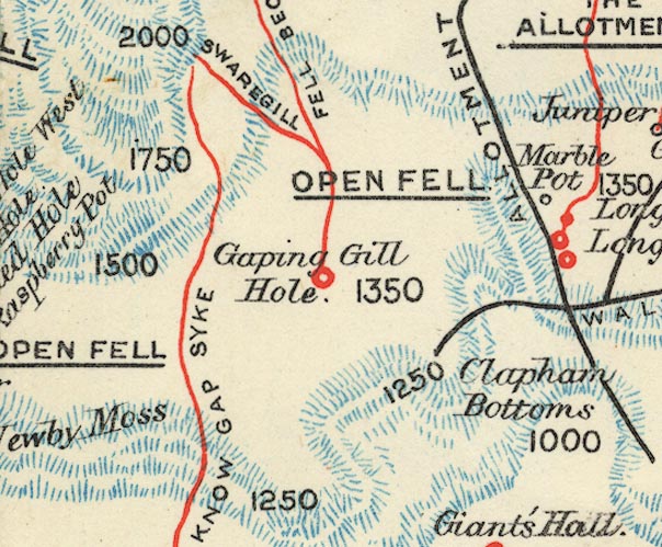 BS1SD77L.jpg "Marble Pot" item:- private collection : 27.1 Image © see bottom of page |
|
|
|
||
Lakes Guides menu.