 Old Cumbria Gazetteer
 |
 |
|
| Maiden Moor, Above Derwent | ||
| Maiden Moor | ||
| locality:- | Derwent Fells | |
| civil parish:- | Above Derwent (formerly Cumberland) | |
| county:- | Cumbria | |
| locality type:- | moor | |
| coordinates:- | NY23731811 (etc) | |
| 1Km square:- | NY2318 | |
| 10Km square:- | NY21 | |
|
|
||
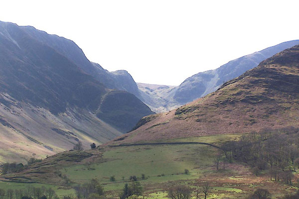 BLZ93.jpg Valley of the Newlands Beck, Maiden Moor on the left, Dale Head at end on right. (taken 3.5.2006) |
||
|
|
||
| evidence:- | old map:- OS County Series (Cmd 70 1) placename:- Maiden Moor |
|
| source data:- | Maps, County Series maps of Great Britain, scales 6 and 25
inches to 1 mile, published by the Ordnance Survey, Southampton,
Hampshire, from about 1863 to 1948. |
|
|
|
||
| evidence:- | old map:- Gents Mag 1751 |
|
| source data:- | Map, uncoloured engraving, Map of the Black Lead Mines in
Cumberland, and area, scale about 2 miles to 1 inch, by George
Smith, published in the Gentleman's Magazine, 1751.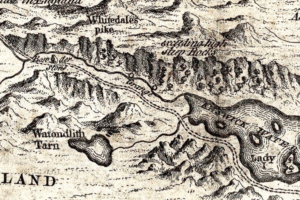 GM1310.jpg "exceeding high Steep Rocks" cliffs item:- JandMN : 114 Image © see bottom of page |
|
|
|
||
| evidence:- | outline view:- Jenkinson 1875 placename:- Maiden Moor |
|
| source data:- | Print, lithograph, outline view, Panoramic Sketches from Helvellyn, Westmorland, by
Edwin A Pettitt, London, published by Edward Stanford, 55 Charing Cross, London, 1875. click to enlarge click to enlargeJk01E1.jpg "... Maiden Moor ..." item:- JandMN : 28.5 Image © see bottom of page |
|
|
|
||
| evidence:- | outline view:- Jenkinson 1875 placename:- Maiden Moor |
|
| source data:- | Print, lithograph, outline view, Panoramic Sketches from Skiddaw, Cumberland, by Edwin
A Pettitt, London, published by Edward Stanford, 55 Charing Cross, London, 1875. click to enlarge click to enlargeJk01E2.jpg "... Maiden Moor ..." item:- JandMN : 28.8 Image © see bottom of page |
|
|
|
||
| evidence:- | outline view:- Jenkinson 1875 placename:- Maiden Moor |
|
| source data:- | Print, lithograph, outline view, Panoramic Sketches from Scawfell Pike, Cumberland,
by Edwin A Pettitt, London, published by Edward Stanford, 55 Charing Cross, London,
1875. click to enlarge click to enlargeJk01E3.jpg "... Maiden Moor ..." item:- JandMN : 28.9 Image © see bottom of page |
|
|
|
||
| evidence:- | outline view:- Black 1856 (23rd edn 1900) placename:- Maiden Moor |
|
| source data:- | Print, lithograph, Outline Views, Skiddaw and Derwent Water - Mountains as seen at
Lodore Hotel, and Mountains as seen at the Third Gate on Ascending Latrigg on the
Way to Skiddaw, by J Flintoft, Keswick, Cumberland, engraved by R Mason, Edinburgh,
Lothian, about 1900.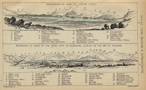 click to enlarge click to enlargeBC08E4.jpg "... 12 Maiden Moor ..." item:- JandMN : 37.14 Image © see bottom of page |
|
|
|
||
| evidence:- | outline view:- Black 1841 (3rd edn 1846) placename:- Maiden Moor |
|
| source data:- | Print, engraving, outline view, Mountains as seen at Lowdore Inn, and Mountains as
seen at the Third Gate on Ascending Latrigg on the Way to Skiddaw, by J Flintoft,
Keswick, Cumberland, engraved by R Mason, Edinburgh, Lothian, about 1846.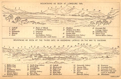 click to enlarge click to enlargeBC02E4.jpg "... 12 Maiden Moor ..." item:- JandMN : 32.7 Image © see bottom of page |
|
|
|
||
| evidence:- | outline view:- Tattersall 1836 placename:- Maiden Moor |
|
| source data:- | Print, engraving, Derwentwater and Entrance to Borrowdale, Cumberland, drawn by George
Tattersall, engraved by W F Topham, published by Sherwood and Co, Paternoster Row,
London, about 1836.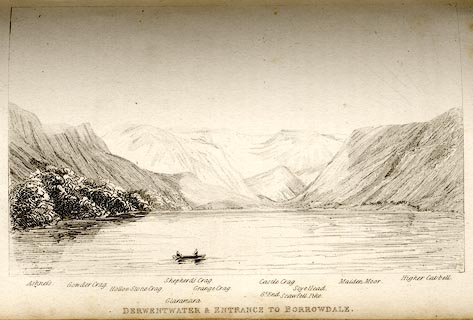 click to enlarge click to enlargeTAT120.jpg The print is captioned with mountain names and acts as an outline view. Tipped in opposite p.60 of The Lakes of England, by George Tattersall. printed at bottom:- "DERWENTWATER &ENTRANCE TO BORROWDALE." printed at bottom left to right:- "Ashness. / Gowder Crag. / Hollow Stone Crag. / Glaramara. / Shepherd's Crag. / Grange Crag. / Castle Crag. / Gt. End. / Scawfell Pike. / Maiden Moor. / Higher Catbell." item:- Armitt Library : A1204.21 Image © see bottom of page |
|
|
|
||
 Lakes Guides menu.