 Old Cumbria Gazetteer
 |
 |
|
| Long Kin West, North Yorkshire | ||
| Long Kin West | ||
| L Hole | ||
| county:- | North Yorkshire | |
| locality type:- | cave | |
| locality type:- | pothole | |
| coordinates:- | SD731724 | |
| 1Km square:- | SD7372 | |
| 10Km square:- | SD77 | |
| SummaryText:- | Explored by Yorkshire Ramblers Club, 1897; extended by Kendal Caving Club, 1969. | |
| SummaryText:- | Grade IV. | |
| references:- | Brook, A & Brook, D & Davies, G M &Long, M H: 1975: Northern Caves, vol.3 Ingleborough:
Dalesman Books (Clapham, North Yorkshire):: ISBN 0 85206 312 1 |
|
|
|
||
| evidence:- | descriptive text:- Balderston c1890 placename:- L Hole placename:- Long Kin West |
|
| source data:- | Book, Ingleton, Bygone and Present, by Robert R and Margaret
Balderston, published by Simpkin, Marshall and Co, London, and
by Edmndson and Co, 24 High Street, Skipton, Yorkshire, about
1890. goto source goto sourcepage 46:- "..." "The L Hole, or Long Kin West" "Proceeding southwards along the Fell to a point about seven furlongs from Crina Bottom, and above the scar that rears its broken rocks behind the farm house called High Leys, is an L-shaped rift of a fearful depth, which might, perhaps, be difficult to find unless certain landmarks were kept in view; from this reason we will give two distinct lines of demarcation. Looking towards the verge of the scar a large boulder-stone may be seen at a distance of about three hundred yards. The line drawn from the boulder over the hole, if prolonged, exactly strikes the great grooved rocks in the western face of Ingleborough's summit where it towers above Foal's Foot. The second line, if drawn from a fragment of broken wall a little to the north-west of the boulder, over the mouth of the hole, first passes directly through an isolated sheep-fold three hundred to four hundred yards further up the moor, and when still further prolonged reaches the summit of the mountain at its centre. If there be no fog little difficulty can be experienced in discovering the situation." "At the end next Ingleborough the depth is not so immense as at the lower corner, and in this portion during wet weather a waterfall may be heard, but very indistinctly seen, the profundity here being eighty-three feet. At the bend of the L just beyond a small bar-like bridge of rock, the long continued clinking of falling stones, and the plummet" goto sourcepage 47:- "attached to an immense length of line reveal the fact that the features of greatest interest are centred here; for not until two hundred and ninety-four feet of line has been played out does the weight attached thereto reach its final rest - one hundred and twenty-two feet deeper than the awful gulf of Rowting Hole, elsewhere described. The depth is terrific, but the associated configuration of rocks and abysm apparent to the eye is not nearly so imposing as that displayed in places much less profound; the spot, however, has its own outlines of beauty, such as nature has given to it, and ought to be visited by those who explore the recesses of these mountains, and, moreover, there are so many other wonderful holes close at hand that an hours detour in this direction is rendered simply delightful." |
|
|
|
||
| evidence:- | possibly old map:- Balderston c1890 map placename:- Long Kin Holes |
|
| source data:- | Map, the hills in the Ingleton area, probably by Robert R
Balderston, engraved by Goodall and Suddick, Leeds, West
Yorkshire, about 1890.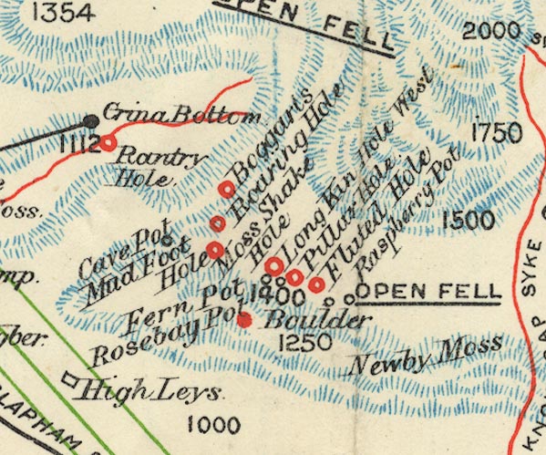 BS1SD77G.jpg "Long Kin Holes" item:- private collection : 27.1 Image © see bottom of page |
|
|
|
||
Lakes Guides menu.