 Old Cumbria Gazetteer
 |
 |
|
| Long Kin East Pot, North Yorkshire | ||
| Long Kin East Pot | ||
| Rift Pot | ||
| county:- | North Yorkshire | |
| locality type:- | cave | |
| locality type:- | pothole | |
| coordinates:- | SD762729 | |
| 1Km square:- | SD7672 | |
| 10Km square:- | SD77 | |
| SummaryText:- | Grade IV if dry; permission, Ingham and Yorke, Littlemoor, Clitheroe. | |
| SummaryText:- | Explored to Rift Pot by Yorkshire Speleological Association, 1906; further descent by Gritstone Club, 1925. | |
| references:- | Brook, A & Brook, D & Davies, G M &Long, M H: 1975: Northern Caves, vol.3 Ingleborough:
Dalesman Books (Clapham, North Yorkshire):: ISBN 0 85206 312 1 |
|
|
|
||
| evidence:- | descriptive text:- Balderston c1890 placename:- Long Kin Holes, East item:- gingling |
|
| source data:- | Book, Ingleton, Bygone and Present, by Robert R and Margaret
Balderston, published by Simpkin, Marshall and Co, London, and
by Edmndson and Co, 24 High Street, Skipton, Yorkshire, about
1890. goto source goto sourcepage 49:- "..." "Long Kin Holes, East." "About three quarters of a mile east by north of Gaping Gill, are Long Kin Holes and Cave, which must be distinguished from the L hole, already described, and sometimes designated by the same name. We had some little trouble in finding these places at first, but, if attention be paid to the landmarks here enumerated, no difficulty will be experienced in discovering the situation of these exceedingly interesting chasms. Whilst walking from Gaping Gill the way is across the open fell or moorland; presently a wall is found on the right, to the south, and one in front, to the east, the latter bounding the moor and running up to the summit of Simon's Fell, a spur of Ingleborough. A large allotment, similar in character to the moor, is beyond this wall. Enter this at the south-west corner, where the two walls meet, and proceed diagonally to" goto sourcepage 50:- "to the north-east up the allotment, and presently, in a slight hollow, a patch of flat limestone rock may be seen protruding from the ground, with a narrow line of green grass between it and the surrounding heather; having reached this point, look upwards along the hollow towards Simon's Fell, and only a very short distance ahead, two or three breaks in a moorland terrace or mound, on the left-hand side of the hollow, may be distinctly seen at a place three to four hundred yards distant from the walls on the south and west already named. Here the Long Kin Holes are situated; the deeper of the two lies more to the north, and has the remains of an old wall around, so inconspicuous, however, as not to be distinguished at a distance. By no means descend the scars; all that is worth seeing is in this allotment." "The southern hole is a long rift of great depth, the line descending through a small orifice in one part of the narrow cleft to a depth of one hundred and fourteen feet." "The northern chasm is much more limited in the extent of its aperture, which is nearly circular, with sharp jutting rock close to the mouth; yet its downward prolongation renders the depth of its partner altogether insignificant, for here the plummet descended two hundred and twenty feet without any serious impediment to its course. Long Kin is a fine gingling hole, and there are large stones in abundance with which to test the resonance of its re-echoing cavities and walls. An oblique passage joins the main shaft some distance below the mouth." goto sourcepage 51:- "... exploration [of Long Kin Cave] leading the cave-hunter towards Long Kin Holes. ..." |
|
|
|
||
| evidence:- | possibly old map:- Balderston c1890 map placename:- Long Kin Cave East |
|
| source data:- | Map, the hills in the Ingleton area, probably by Robert R
Balderston, engraved by Goodall and Suddick, Leeds, West
Yorkshire, about 1890.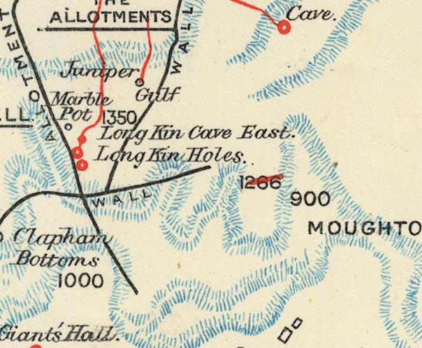 BS1SD77R.jpg "Long Kin Cave East" item:- private collection : 27.1 Image © see bottom of page |
|
|
|
||
Lakes Guides menu.