 Old Cumbria Gazetteer
 |
 |
|
| Long Kin East Cave, North Yorkshire | ||
| Long Kin East Cave | ||
| county:- | North Yorkshire | |
| locality type:- | cave | |
| coordinates:- | SD762731 | |
| 1Km square:- | SD7673 | |
| 10Km square:- | SD77 | |
| SummaryText:- | Grade I; permission Ingham and Yorke, Littlemoor, Clitheroe. | |
| references:- | Brook, A & Brook, D & Davies, G M &Long, M H: 1975: Northern Caves, vol.3 Ingleborough:
Dalesman Books (Clapham, North Yorkshire):: ISBN 0 85206 312 1 |
|
|
|
||
| evidence:- | descriptive text:- Balderston c1890 placename:- Long Kin Cave |
|
| source data:- | Book, Ingleton, Bygone and Present, by Robert R and Margaret
Balderston, published by Simpkin, Marshall and Co, London, and
by Edmndson and Co, 24 High Street, Skipton, Yorkshire, about
1890. goto source goto sourcepage 50:- "..." "Long Kin Cave." "Diverting one's steps for a short distance along the same hollow, a small stream, which at low water is very puny, is found traversing the summit of the beds of" goto sourcepage 51:- "limestone, where it has washed away the moorland turf. Suddenly the little brook appears to sink into its own bed, but on closer inspection a rift, fifteen yards long and two to three feet wide, is found to be the cause of the disappearance, the brook leaping by a series of low cascades, into the bottom, so as to ultimately run at a depth of about twelve feet below the ground. At the lower end of the rift the beds of limestone become higher, so that the channel has a roof stretching across it, the result being a cave, one that is well worth visiting, exploration leading the cave-hunter towards Long Kin Holes. The height at the mouth is twelve and a half feet, with a width of two to two-and-a-half. After having traversed a few yards, the passage suddenly turns to the left, round a fine dome-shaped projection of rock, finely rounded and hollowed below by the stream, whilst in the upper portion receding in the same direction. The cave, being a cavern of engulfment, or one which has to be entered from above, great caution must be observed in the descent, so as to avoid slips or falls down cascades or holes. At a distance of forty-five yards is a second bold corner, and at a point sixty-two yards from the mouth, a flexure occurs in the opposite direction, with a black or ebon-looking cranny or rift in the corner, made thereby, in which is a dropping well, at least in wet weather. Seven yards further there is another bend, whilst at a distance of one hundred and fourteen yards from the entrance a slight widening of the cavern takes place, and in the centre of the small chamber thus formed is a large boulder; by advancing eighteen yards a slight rift in the south-eastern wall is reached, through which glimpses of daylight may be seen. Beyond this point the descent of the cave is more rapid; the passage is narrow, and about one hundred and forty-four yards from the mouth has a most peculiar conformation, the south-eastern wall being hollowed below, but abruptly protuberant across the passage" goto sourcepage 52:- "at a higher level, whilst the north-western side has a great projecting ledge below, with hollowed face above, as if the opposing surfaces had been made to fit each other, but had slipped away from their point of meeting. Advancing thirteen yards along the narrow passage, the walls are again found to become more vertical, with strange, longitudinal ribs marking their jagged faces. Having traversed the rocky intestine of the mountain for a distance of two hundred and seven yards, the descent of the stream is exceedingly rapid and tumultuous after heavy rains." |
|
|
|
||
| evidence:- | possibly old map:- Balderston c1890 map placename:- Long Kin Cave East |
|
| source data:- | Map, the hills in the Ingleton area, probably by Robert R
Balderston, engraved by Goodall and Suddick, Leeds, West
Yorkshire, about 1890.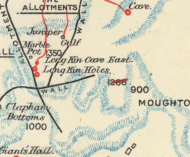 BS1SD77R.jpg "Long Kin Cave East" item:- private collection : 27.1 Image © see bottom of page |
|
|
|
||
Lakes Guides menu.