 Old Cumbria Gazetteer
 |
 |
|
| King Garth, Kingmoor | ||
| King Garth | ||
| civil parish:- | Kingmoor (formerly Cumberland) | |
| county:- | Cumbria | |
| locality type:- | buildings | |
| coordinates:- | NY35505985 | |
| 1Km square:- | NY3559 | |
| 10Km square:- | NY35 | |
|
|
||
| evidence:- | old map:- OS County Series (Cmd 16 9) placename:- Kinggarth |
|
| source data:- | Maps, County Series maps of Great Britain, scales 6 and 25
inches to 1 mile, published by the Ordnance Survey, Southampton,
Hampshire, from about 1863 to 1948. "King-garth" |
|
|
|
||
| evidence:- | old map:- Donald 1774 (Cmd) placename:- Kingarth |
|
| source data:- | Map, hand coloured engraving, 3x2 sheets, The County of Cumberland, scale about 1
inch to 1 mile, by Thomas Donald, engraved and published by Joseph Hodskinson, 29
Arundel Street, Strand, London, 1774.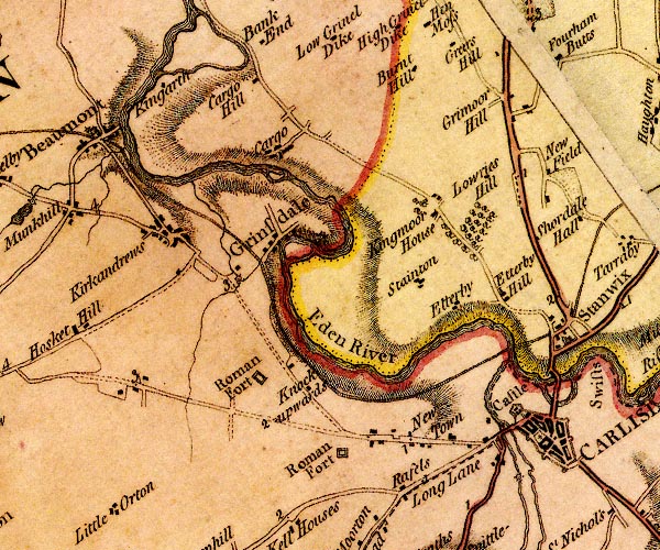 D4NY35NE.jpg "Kingarth" block or blocks, labelled in lowercase; a hamlet or just a house item:- Carlisle Library : Map 2 Image © Carlisle Library |
|
|
|
||
| evidence:- | database:- Listed Buildings 2010 placename:- King Garth item:- date stone (1780); date stone (1782) |
|
| source data:- | courtesy of English Heritage "KING GARTH AND STABLES NY 355598 / / / KINGMOOR / CARLISLE / CUMBRIA / II / 78357 / NY3550059800" |
|
|
|
||
 Lakes Guides menu.