 Old Cumbria Gazetteer
 |
 |
|
||||||||||||||||||||||||
| Kendal Fell, Kendal | ||||||||||||||||||||||||||
| Kendal Fell | ||||||||||||||||||||||||||
| civil parish:- | Kendal (formerly Westmorland) | |||||||||||||||||||||||||
| county:- | Cumbria | |||||||||||||||||||||||||
| locality type:- | hill | |||||||||||||||||||||||||
| locality type:- | fell | |||||||||||||||||||||||||
| coordinates:- | SD50559302 (etc) | |||||||||||||||||||||||||
| 1Km square:- | SD5093 | |||||||||||||||||||||||||
| 10Km square:- | SD59 | |||||||||||||||||||||||||
|
|
||||||||||||||||||||||||||
| evidence:- | old map:- OS County Series (Wmd 38 8) placename:- Kendal Fell |
|||||||||||||||||||||||||
| source data:- | Maps, County Series maps of Great Britain, scales 6 and 25
inches to 1 mile, published by the Ordnance Survey, Southampton,
Hampshire, from about 1863 to 1948. |
|||||||||||||||||||||||||
|
|
||||||||||||||||||||||||||
| evidence:- | old map:- Jefferys 1770 |
|||||||||||||||||||||||||
| source data:- | Map, 4 sheets, The County of Westmoreland, scale 1 inch to 1
mile, surveyed 1768, and engraved and published by Thomas
Jefferys, London, 1770.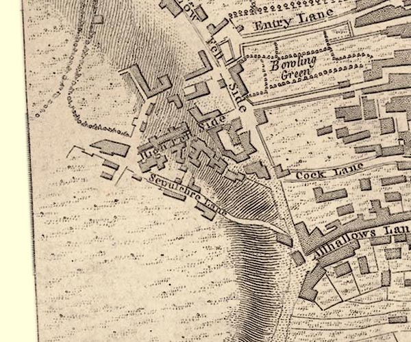 J55192I.jpg 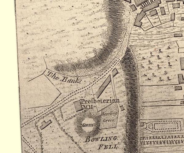 J55192H.jpg hill hachuring item:- National Library of Scotland : EME.s.47 Images © National Library of Scotland |
|||||||||||||||||||||||||
|
|
||||||||||||||||||||||||||
| evidence:- | descriptive text:- West 1778 (11th edn 1821) |
|||||||||||||||||||||||||
| source data:- | Guide book, A Guide to the Lakes, by Thomas West, published by
William Pennington, Kendal, Cumbria once Westmorland, and in
London, 1778 to 1821. goto source goto sourcePage 190:- "A TABLE OF THE Height of Mountains and Lakes SEEN IN THIS TOUR, ... TAKEN FROM THE LEVEL OF THE SEA. ... by Mr. John Dalton." "Kendal-fell, N.W. summit ... 216 [yards]" |
|||||||||||||||||||||||||
|
|
||||||||||||||||||||||||||
| evidence:- | old text:- Gents Mag item:- geology; fossil; stink stone |
|||||||||||||||||||||||||
| source data:- | Magazine, The Gentleman's Magazine or Monthly Intelligencer or
Historical Chronicle, published by Edward Cave under the
pseudonym Sylvanus Urban, and by other publishers, London,
monthly from 1731 to 1922. goto source Gentleman's Magazine 1794 p.111 "..." "We set off from Kendal on the first of August, on foot; which mode of travelling a judicious Naturalist will always prefer, because it affords him the best opportunity of pursuing his favourite study." "Kendal Fell is a hill which does not rise more than 160 yards above the river Kent in the highest part, The superior strata, to a great depth, consist of compact limestone, being that variety called stink stone as it emits a disagreeable smell when rubbed against a hard body, Its colour is grey, its fracture rough, and its specific gravity [2.723]. It abounds with petrifactions," |
|||||||||||||||||||||||||
|
|
||||||||||||||||||||||||||
| evidence:- | old text:- Gents Mag 1794 |
|||||||||||||||||||||||||
| source data:- | goto source Gentleman's Magazine 1794 p.112 "principally of the bivalve kind, which are very frequently mutilated. This vast mass of calcareous matter terminates in an extensive field of the same, occupying the valley to the South, In this part it rests on an elevated ridge of the grey variety of the shistus fuscus, which is the common stone of the country to the North, and even takes place immediately on the East side of the river, where no limestone appears parallel to the hill; but the natural rock is never seen in the low grounds excepting by those who sink deep wells; for, it is buried beneath a thick covering of sand and pebbles, that forms the bed of the Kent, and extends up the declivities on both sides of it to a height far exceeding the limits of the present channel. ..." |
|||||||||||||||||||||||||
|
|
||||||||||||||||||||||||||
| evidence:- | descriptive text:- Otley 1823 (5th edn 1834) item:- geology |
|||||||||||||||||||||||||
| source data:- | Guide book, A Concise Description of the English Lakes, the
mountains in their vicinity, and the roads by which they may be
visited, with remarks on the mineralogy and geology of the
district, by Jonathan Otley, published by the author, Keswick,
Cumberland now Cumbria, by J Richardson, London, and by Arthur
Foster, Kirkby Lonsdale, Cumbria, 1823; published 1823-49,
latterly as the Descriptive Guide to the English Lakes. goto source Page 161:- "A superincumbent bed of limestone, by some called the mountain, by others the upper transition limestone, mantles round these mountains, in a position unconformable to the strata of the slaty and other rocks upon which it reposes. It bassets out near ... Lowther and Shap; it appears again near Kendal," "..." |
|||||||||||||||||||||||||
|
|
||||||||||||||||||||||||||
| evidence:- | descriptive text:- Ford 1839 (3rd edn 1843) placename:- Kendal Fell item:- altitude, Kendal Fell |
|||||||||||||||||||||||||
| source data:- | Guide book, A Description of Scenery in the Lake District, by
Rev William Ford, published by Charles Thurnam, Carlisle, by W
Edwards, 12 Ave Maria Lane, Charles Tilt, Fleet Street, William
Smith, 113 Fleet Street, London, by Currie and Bowman,
Newcastle, by Bancks and Co, Manchester, by Oliver and Boyd,
Edinburgh, and by Sinclair, Dumfries, 1839. goto source Page 178:- "ELEVATION OF THE MOUNTAINS," "ACCORDING TO DIFFERENT AUTHORITIES."
|
|||||||||||||||||||||||||
|
|
||||||||||||||||||||||||||
Lakes Guides menu.