 Old Cumbria Gazetteer
 |
 |
|
| Kelton and Knockmurton Mines, Lamplugh | ||
| Kelton and Knockmurton Mines | ||
| site name:- | Murton Fell | |
| site name:- | Kelton Fell | |
| site name:- | Kelton Park | |
| civil parish:- | Lamplugh (formerly Cumberland) | |
| county:- | Cumbria | |
| locality type:- | iron mine | |
| locality type:- | mine | |
| coordinates:- | NY095190 | |
| coordinates:- | NY095180 | |
| coordinates:- | NY085183 | |
| 1Km square:- | NY0919 | |
| 1Km square:- | NY0918 | |
| 1Km square:- | NY0818 | |
| 10Km square:- | NY01 | |
| references:- | Adams, John: 1988: Mines of the Lake District Fells: Dalesman Books (Lancaster, Lancashire)::
ISBN 0 85206 931 6 |
|
|
|
||
| evidence:- | old text:- Postlethwaite 1877 (3rd edn 1913) placename:- Kelton and Knockmurton Mines item:- iron ore; haematite |
|
| source data:- | Book, Mines and Mining in the English Lake District, by John Postlethwaite, Keswick,
published by W H Moss and Sons, Whitehaven, Cumberland now Cumbria, 1877; published
1877-1913. goto source goto sourcepage 109:- "KELTON AND KNOCKMURTON MINES." "There are a great number of veins of haematite iron in the Skiddaw Slate Rocks, but most of them are small and unimportant. The most valuable yet discovered are those on Kelton Fell, and at Knockmurton, near the margin of the area where haematite iron is found in such abundance in the carboniferous limestone of the Cleator District, and not far from Ennerdale Lake. The bearings of the veins is north-west and south-east, and the hade, which varies in degree, is towards the north-east. The ore occurs mostly in lenticular masses, or "bunches," varying in width from a few inches up to ten, and in one such mass, to twenty-three feet; and this variation occurs in vertical as well as in lateral measurement, some of the bunches being over fifty fathoms in length." "These mines are worked by levels driven into the hill at various elevations. The greatest length that has been driven in" goto sourcepage 110:- "any of these levels is about 240 fathoms, and the greatest depth about 56 fathoms." "The mine at Knockmurton is the oldest, having been worked almost continuously for about sixty years. The mines on Kelton Fell, which are owned by the same Company, were opened more recently." "The quantity of ore obtained from Kelton and Knockmurton Mines in 1872 was 14,435 tons; in 1873 20,676 tons; in 1877 about 30,000 tons; and in 1888 46,100 tons." "In 1909 the output from these mines was 27,160 tons." |
|
|
|
||
| evidence:- | old map:- Postlethwaite 1877 (3rd edn 1913) placename:- Knock Murton Mine placename:- Kelton Mine |
|
| source data:- | Map, uncoloured engraving, Map of the Lake District Mining Field, Westmorland, Cumberland,
Lancashire, scale about 5 miles to 1 inch, by John Postlethwaite, published by W H
Moss and Sons, 13 Lowther Street, Whitehaven, Cumberland, 1877 edn 1913.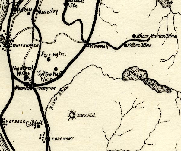 PST2NY01.jpg "Kelton Mine" "Knock Murton Mine" mine symbol item:- JandMN : 162.2 Image © see bottom of page |
|
|
|
||
| :- |
System of haematite mines begun about 1853; prosperous from 1870s to 1914; worked
out and abandoned 1914, but reworked 1920s. |
|
| Adams, John: 1988: Mines of the Lake District Fells: Dalesman Books (Lancaster, Lancashire)::
ISBN 0 85206 931 6 |
||
|
|
||
| notes:- |
Opened by William Baird and Co, 1869. |
|
|
|
||
Lakes Guides menu.