 Old Cumbria Gazetteer
 |
 |
|
| Jingling Caves, North Yorkshire | ||
| Jingling Caves | ||
| site name:- | Jingling Caves Bank (?) | |
| site name:- | Gragareth | |
| county:- | North Yorkshire | |
| locality type:- | cave | |
| coordinates:- | SD698782 | |
| coordinates:- | SD699784 | |
| 1Km square:- | SD6978 | |
| 10Km square:- | SD67 | |
| altitude:- | 1240 feet | |
| altitude:- | 378m | |
| SummaryText:- | Grade II; permission from Ireby Hall Farm, Cowan Bridge. | |
| references:- | Brook, D & Davies, G & Long, M H &Sutcliffe, J R: 1975: Northern Caves, vol.4 Whernside
and Gragareth: Dalesman Books:: ISBN 0 85206 259 1 |
|
|
|
||
| evidence:- | descriptive text:- West 1778 (11th edn 1821) placename:- Gingling Cave |
|
| source data:- | Guide book, A Guide to the Lakes, by Thomas West, published by
William Pennington, Kendal, Cumbria once Westmorland, and in
London, 1778 to 1821. goto source goto sourceTour to the Caves in the West Riding of Yorkshire, late 18th century Page 250:- "..." "[from Yordas Gill] We were persuaded to climb up to the top of the base of Gragareth, the mountain in whose side Yordas is situated, in order to see Gingling-cave. It is on the edge of that flat base of the mountain, on a green plain by the side of a brook, looking down into the vale; Ingleborough appearing a little to the left, or north-east of Breda-Garth, which was almost opposite. This natural curiosity is a round aperture, narrow at the top, but most probably dilating in its dimensions to a profound extent. The stones we threw in made an hollow" goto sourcePage 251:- "gingling noise for a considerable time. At intervals we could hear nothing of their descent; then again we heard them resound in deeper keys, till they were either immersed in some deep pool, or arrived at too great a distance to be heard: for there seemed a variety of different passages for their descent, some being much sooner intercepted in their career than others. Two dogs that were with us, and a small horse brought up by one of the party, seemed violently agitated, and under fearful trepidations, under horrors resembling those we are told the animal creation are seized with preceeding or during an earthquake. Though our reason convinced us of the impossibility of the ground falling in beneath us, we could not but feel many apprehensions, accompanied with sensations hitherto unknown.- We could not learn that any swain had ever been adventurous enough to be let down by ropes in the vast hiatus, to explore those unseen regions, either from a principle of curiosity, or to search for hidden mines.- We were informed of some other openings into this mountain, of a like kind with Gingling-cave, but being at a distance, and of an inferior nature, we returned to Yordas for our horses, which we had pent up in the sheep folds, ..." |
|
|
|
||
| evidence:- | descriptive text:- Balderston c1890 placename:- Gingling Cave item:- gingling; stalactite |
|
| source data:- | Book, Ingleton, Bygone and Present, by Robert R and Margaret
Balderston, published by Simpkin, Marshall and Co, London, and
by Edmndson and Co, 24 High Street, Skipton, Yorkshire, about
1890. goto source page 63:- "..." "Gingling Cave and Hole." "The name of Gingling Hole is given to another pot further north, owing to the peculiar and continuous rattling and clinking sound produced, when a stone is thrown into the cavity - which is very narrow at the mouth - in rebounding along as in the case of the other chasm of the same name at Chapel-le-Dale. The measuring line descends in this hole without stoppage one hundred and forty-one feet; we tried the depth in various places, and this was the utmost, though it has been stated that one hundred and fifty was the amount. A stream runs past the Hole only a few yards to the west, and enters a low cave a very short distance further to the south, fifteen yards in length; it is then engulfed in another, running sleepily and with little fall along and within the scar. Sixty-seven yards from the mouth is a stalactitic partition; after that there are fine stalactitic lines, cones, &c., with fluting at intervals. The" goto sourcepage 64:- "cave is low, with little variation for two hundred and twenty-five yards." |
|
|
|
||
| evidence:- | old map:- Balderston c1890 map placename:- Gingle Hole and Cave |
|
| source data:- | Map, the hills in the Ingleton area, probably by Robert R
Balderston, engraved by Goodall and Suddick, Leeds, West
Yorkshire, about 1890.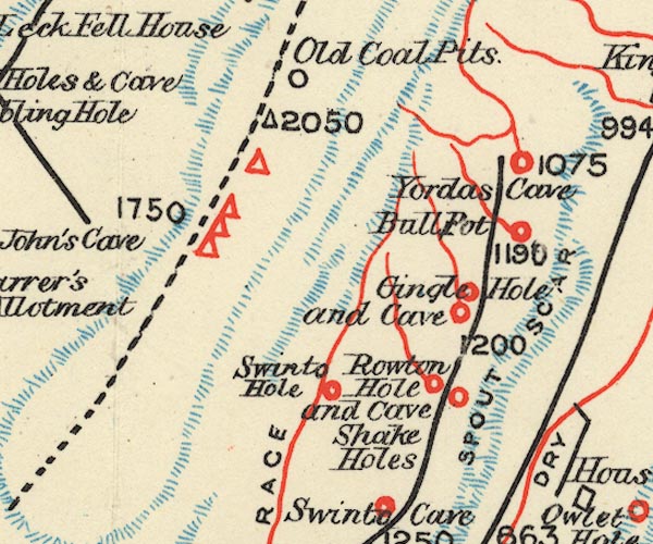 BS1SD67Z.jpg "Gingle Hole and Cave" item:- private collection : 27.1 Image © see bottom of page |
|
|
|
||
Lakes Guides menu.