 Old Cumbria Gazetteer
 |
 |
|
| Jingle Pot, North Yorkshire | ||
| Jingle Pot | ||
| site name:- | Whernside | |
| locality:- | Chapel-le-Dale | |
| county:- | North Yorkshire | |
| locality type:- | cave | |
| coordinates:- | SD738774 | |
| 1Km square:- | SD7377 | |
| 10Km square:- | SD77 | |
| references:- | Brook, A & Brook, D & Davies, G M &Long, M H: 1975: Northern Caves, vol.3 Ingleborough:
Dalesman Books (Clapham, North Yorkshire):: ISBN 0 85206 312 1 |
|
|
|
||
| evidence:- | descriptive text:- West 1778 (3rd edn 1784) |
|
| source data:- | Guide book, A Guide to the Lakes, by Thomas West, published by
William Pennington, Kendal, Cumbria once Westmorland, and in
London, 1778 to 1821. goto source goto source3rd edn addenda, page 229:- "..." "Nigh the Chapel in the dale, on the north side of Ingleborough, I met with three caverns that are totally unlike any in this island, tho' caverns are common in all limestone countries. ... A quarter of a mile above this [Hurtle Pot] is another pit, of a paralellopiped (sic) form, being a chasm between two perpendicular rocks, and though upwards of forty yards deep, one may easily leap over it. It seems one of those breaks, or faults (as miners call 'em) where the regular strata have been broken, and one part of them has sunk below the other; for the bands of rock lie pretty horizontal, and in their fissures are found fossils of very curious genera, shells, fish-bones, pipy flints, with concretes of shells, stones, moss, and other vegetables, in one mass. Small screw-like cylinders, some with holes through, which all effervesce with an acid, and creep in a plate filled with vinegar, like those found near Carrickfergus, in Ireland, by the discharge of their fixt air." |
|
|
|
||
| evidence:- | descriptive text:- West 1778 (11th edn 1821) placename:- Ginglepot |
|
| source data:- | Guide book, A Guide to the Lakes, by Thomas West, published by
William Pennington, Kendal, Cumbria once Westmorland, and in
London, 1778 to 1821. goto source Tour to the Caves in the West Riding of Yorkshire, late 18th century Page 257:- "..." "When we arrived in the superior regions [from Hurtlepot], we pursued our journey about a hundred and fifty yards farther up a very narrow grotesque glen, over a natural bridge of limestone above ten yards thick, having the subterranean river Wease, or Greta, underneath. When we got to the head of this gill, we were stopped by a deep chasm called Ginglepot, at the bottom of a precipice. It is of an oblong and narrow form. An enterprising person, with a steady head and active heels, regardless of the fatal consequences from a false step, might leap over it. It is filled with smooth pebbles at the bottom except the south corner, where there is a deep water, which, in floods, swells up to the top, and issues out in a vast torrent. The length of this chasm is about ten yards, and the perpendicular depth at the north corner, about twenty yards.- ..." goto sourcePage 258:- "..." "Returning back a little way from Ginglepot, in order to find a passage out of this dreary glen, we proceeded about an hundred and twenty yards higher, when we came to Weathercoat cave, ..." "... The delicate and timid may neither be afraid of their persons or clothes, if they have no mind to descend: they may stand safe on the margin of either Hurtlepot, Ginglepot, or Weathercoat-cave. They will there see enough to astonish them, and imagination will supply the rest." goto sourcePage 259:- "[in Weathercoat cave] ... The water sinks as its (sic) falls amongst the rocks and pebbles, running by a subterranean passage about a mile, when it appears again by the side of the turnpike road, visiting in its way the other caverns of Ginglepot and Hurtlepot. ..." goto sourcePage 260:- "the bottom [of Weathercoat cave] we were shown a crevice, where we might descend to the subterranean channel, which would lead us to Ginglepot, and perhaps much farther: we were also shown above a shallow passage between the strata of rocks, along which we might crawl to the orifice out of which the cascade issued, where it was high enough to walk erect, and where we might have the honour of making the first expedition for discoveries, no creature having yet proceeded in that passage out of sight of day-light: but as we were apprehensive the dangers and difficulties to be encountered in our progress, would not be compensated by the pleasure, we did not attempt to explore these new regions [1]. ..." "[1] The writer of this Tour, in company with the owner of the cave, and some others, has since been in the passage out of which the cascade issues, but is not able to tell how far it extends, as it was high and wide enough to admit passengers much farther than they were. The owner of the cave, and others, have been in the passage beneath, half way to Ginglepot: they have no doubt but it leads thither: they did not get so far, owing to the water deepening, more than the height lessening. ..." |
|
|
|
||
| evidence:- | descriptive text:- Otley 1823 (8th edn 1849) placename:- Gingle Pot |
|
| source data:- | Guide book, A Concise Description of the English Lakes, the
mountains in their vicinity, and the roads by which they may be
visited, with remarks on the mineralogy and geology of the
district, by Jonathan Otley, published by the author, Keswick,
Cumberland now Cumbria, by J Richardson, London, and by Arthur
Foster, Kirkby Lonsdale, Cumbria, 1823; published 1823-49,
latterly as the Descriptive Guide to the English Lakes. goto source Page 199:- "..." "GINGLE POT is a natural chasm in the bed of the rock, about 23 yards long, 3 yards broad, and 16 yards deep, 200 yards south of Weathercote. At its southren (sic) extremity is a passage leading to the stream, which loses itself in that cave. When a stone is cast down, it produces a peculiarly hollow and gingling sound, from which, as in the case of Gingling Cave in Gregareth, it derives its name. During floods, the water boils out of this hole. It is situated at the foot of a precipice, and is hidden from view by trees." |
|
|
|
||
| evidence:- | descriptive text:- Balderston c1890 placename:- Gingle Pot placename:- Jingle Pot item:- gingling |
|
| source data:- | Book, Ingleton, Bygone and Present, by Robert R and Margaret
Balderston, published by Simpkin, Marshall and Co, London, and
by Edmndson and Co, 24 High Street, Skipton, Yorkshire, about
1890. goto source page 36:- "..." "Gingle Pot, or Jingle Pot," "Is at a distance of less than one hundred yards from the cave just described [Weathercote Cave], it is forty-five feet deep on the northern side, and is placed at the bottom of a rock about sixty-one feet high, where it meets the end of the rift on the north-west side. Its length is some twenty-three yards, with a width of three. From this description the reader will discover that Gingle Pot is a natural rift in the rocks; and it receives its name from the strange jingling, rattling sound made by stones when thrown into its recesses. Had the deepest portion of the chasm been next the lofty rock at its other extremity the height of the cliff would have been still more imposing. As in the case of Weathercote, water issues from the rupture in the stratification during the time of heavy freshets, the subterranean passages of many of the underground streams of this district being wholly inadequate to convey the excess of water pouring from the mountains." |
|
|
|
||
| evidence:- | old map:- Balderston c1890 map placename:- Gingle Pot |
|
| source data:- | Map, the hills in the Ingleton area, probably by Robert R
Balderston, engraved by Goodall and Suddick, Leeds, West
Yorkshire, about 1890.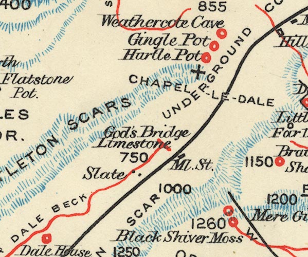 BS1SD77I.jpg "Gingle Pot" item:- private collection : 27.1 Image © see bottom of page |
|
|
|
||
Lakes Guides menu.