 Old Cumbria Gazetteer
 |
 |
|
| inn, Scale Hill | ||
| locality:- | Scale Hill | |
| civil parish:- | Buttermere (formerly Cumberland) | |
| county:- | Cumbria | |
| locality type:- | buildings | |
| coordinates:- | NY150216 | |
| 1Km square:- | NY1521 | |
| 10Km square:- | NY12 | |
|
|
||
| evidence:- | old map:- Crosthwaite 1783-94 (But/Cru/Low) placename:- Inn, The |
|
| source data:- | Map, uncoloured engraving, An Accurate Map of Buttermere,
Crummock and Loweswater Lakes, scale about 3 inches to 1 mile,
by Peter Crosthwaite, Keswick, Cumberland, 1794, version
published 1800.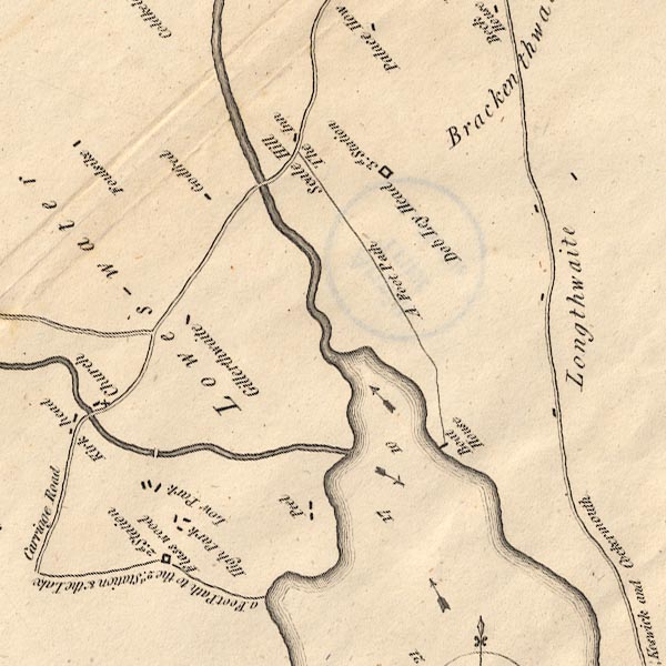 CT8NY12K.jpg "The Inn" At Scale Hill item:- Armitt Library : 1959.191.2 Image © see bottom of page |
|
|
|
||
| evidence:- | old text:- Green 1814 |
|
| source data:- | Set of prints, soft ground etchings, Sixty Small Prints, with
text, A Description of a Series of Sixty Small Prints, by
William Green, Ambleside, Westmorland, 1814. goto source goto sourcepage 21:- "... The Inn at Scale Hill (which is about half a mile from the outlet of Crummock Water and eleven miles from Keswick), and the Inn at Buttermere, are both of them excellent stationary places from which to see Buttermere, Crummock Water, Lows Water, and Ennerdale Water. ..." |
|
|
|
||
| evidence:- | descriptive text:- Otley 1823 (5th edn 1834) |
|
| source data:- | Guide book, A Concise Description of the English Lakes, the
mountains in their vicinity, and the roads by which they may be
visited, with remarks on the mineralogy and geology of the
district, by Jonathan Otley, published by the author, Keswick,
Cumberland now Cumbria, by J Richardson, London, and by Arthur
Foster, Kirkby Lonsdale, Cumbria, 1823; published 1823-49,
latterly as the Descriptive Guide to the English Lakes. goto source Page 23:- "... There is a comfortable inn at Buttermere, between the two lakes, and another at Scale Hill on the foot of Crummock; at one of which places a boat is usually taken, as well for a survey of the scenery, as being the most convenient way of seeing the noted waterfall of Scale Force, on the opposite side of the lake." |
|
|
|
||
| evidence:- | old map:- Garnett 1850s-60s H placename:- Scale Hill Inn |
|
| source data:- | Map of the English Lakes, in Cumberland, Westmorland and
Lancashire, scale about 3.5 miles to 1 inch, published by John
Garnett, Windermere, Westmorland, 1850s-60s.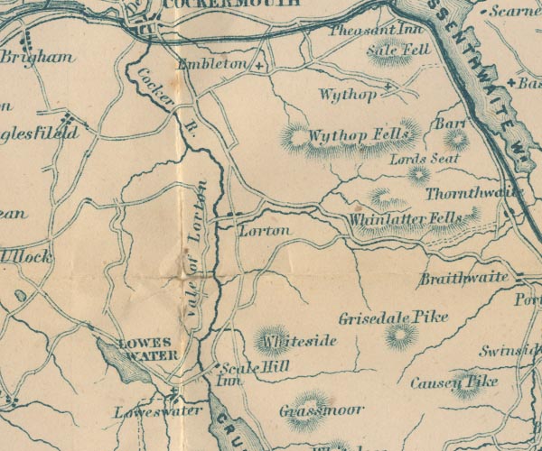 GAR2NY12.jpg "Scale Hill Inn" block, building item:- JandMN : 82.1 Image © see bottom of page |
|
|
|
||
| evidence:- | old text:- Martineau 1855 placename:- Scale Hill Inn |
|
| source data:- | Guide book, A Complete Guide to the English Lakes, by Harriet
Martineau, published by John Garnett, Windermere, Westmorland,
and by Whittaker and Co, London, 1855; published 1855-76. goto source Page 85:- "... till it [the road] passes behind the Lanthwaite Woods, and turns down, in full view of the rich Vale of Lorton, to Scale Hill Inn. That best and most home-like of inns should be the traveller's resting" goto sourcePage 86:- "place for days together, if he desires a central point whence he may visit a great extent of the lake country, while in command of a variety of pleasures near at hand. ..." |
|
|
|
||
Lakes Guides menu.