 Old Cumbria Gazetteer
 |
 |
|
| Hull Pot, North Yorkshire | ||
| Hull Pot | ||
| site name:- | Hull Pot Beck | |
| site name:- | Horton Moor | |
| site name:- | Pen-y-ghent | |
| county:- | North Yorkshire | |
| locality type:- | cave | |
| locality type:- | pothole | |
| coordinates:- | SD824745 | |
| 1Km square:- | SD8274 | |
| 10Km square:- | SD87 | |
|
|
||
| evidence:- | descriptive text:- West 1778 (11th edn 1821) placename:- Hulpit Hole |
|
| source data:- | Guide book, A Guide to the Lakes, by Thomas West, published by
William Pennington, Kendal, Cumbria once Westmorland, and in
London, 1778 to 1821. Tour to the Caves in the West Riding of Yorkshire, late 18th century  goto source goto sourcePage 275:- "..." "... About a mile or two above Horton, upon the base of Pennegant, we visited Hulpit and Huntpit-holes. The one, if we could have descended into it, would have appeared like the inside of an enormous old Gothic castle, the high ruinous walls of which were left standing after the roof was fallen in: the other was like a deep funnel, and it was dangerous to come near its edges. Horton-beck, or brook, runs through the one, and Bransil-beck through the other of these pits, but through which I cannot remember: ..." |
|
|
|
||
| evidence:- | old map:- Balderston c1890 map placename:- Hull Pot |
|
| source data:- | Map, the hills in the Ingleton area, probably by Robert R
Balderston, engraved by Goodall and Suddick, Leeds, West
Yorkshire, about 1890.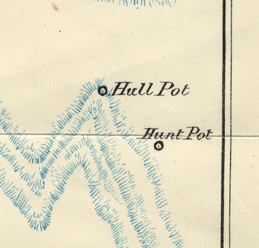 BS1SD87H.jpg "Hull Pot" item:- private collection : 27.1 Image © see bottom of page |
|
|
|
||
Lakes Guides menu.