 Old Cumbria Gazetteer
 |
 |
|
| Homeshaw Cave, North Yorkshire | ||
| Homeshaw Cave | ||
| county:- | North Yorkshire | |
| locality type:- | cave | |
| locality type:- | pothole | |
| coordinates:- | SD74327960 | |
| 1Km square:- | SD7479 | |
| 10Km square:- | SD77 | |
| altitude:- | 1100 feet | |
| altitude:- | 335m | |
| SummaryText:- | Explored further by Universoty of Leeds Speleological Association, 1966. | |
| SummaryText:- | Grade III; permission from Ivescar Farm. | |
| references:- | Brook, D & Davies, G & Long, M H &Sutcliffe, J R: 1975: Northern Caves, vol.4 Whernside
and Gragareth: Dalesman Books:: ISBN 0 85206 259 1 |
|
|
|
||
| evidence:- | descriptive text:- Balderston c1890 placename:- Homeshaw Cave |
|
| source data:- | Book, Ingleton, Bygone and Present, by Robert R and Margaret
Balderston, published by Simpkin, Marshall and Co, London, and
by Edmndson and Co, 24 High Street, Skipton, Yorkshire, about
1890. goto source goto sourcepage 39:- "..." "Homeshaw Cave." "About three-quarters of a mile north-east of Bruntscar, behind the edge of a low line of rocks called Scar Top, is a kind of shakehole with small trees about it. On descending the hollow two caves are found, one of debouchure, the other of engulfment, the latter being fully worthy of exploration, and in fact an upper branch of Gatekirk Cave. The former is really a still further upward prolongation of the same series of caves, but our ascent therein was by no means pleasant, for the roof was low and a narrow pool, filling a rift and gradually deepening, extended some distance inwards, and the ascent had to be made by" goto sourcepage 40:- "crawling along ledges instead of wading in an erect position. The lower cave, however, was quite otherwise. Almost immediatly (sic) after entering, a descent of about fifteen feet had to be made, and then another of ten, but this was facilitated by a long piece of wood laid obliquely downwards so as to give assistance to the feet, whilst the hands clutched the projections of the narrow walls. About twenty-two yards from the mouth the cave became more spacious, with the roof apparently at least twenty feet high and the chamber dome shaped. After this point the passage again grew narrow and serpentine, presenting characters of wall configuration very similar to those which are such marked features of Browside, Lost John's (sic), and Long Kin Caves. There are two fine cascades at the places of descent near the mouth in wet weather, and also others at various points further away." |
|
|
|
||
| evidence:- | old map:- Balderston c1890 map placename:- Homeshaw Caves |
|
| source data:- | Map, the hills in the Ingleton area, probably by Robert R
Balderston, engraved by Goodall and Suddick, Leeds, West
Yorkshire, about 1890.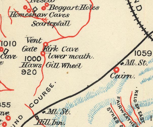 BS1SD77P.jpg "Homeshaw Caves" item:- private collection : 27.1 Image © see bottom of page |
|
|
|
||
Lakes Guides menu.