 Old Cumbria Gazetteer
 |
 |
|
| Hill Top, New Hutton | ||
| Hill Top | ||
| Holme Park School | ||
| locality:- | Monument Hill | |
| civil parish:- | New Hutton (formerly Westmorland) | |
| county:- | Cumbria | |
| locality type:- | buildings | |
| locality type:- | school | |
| coordinates:- | SD54799121 | |
| 1Km square:- | SD5491 | |
| 10Km square:- | SD59 | |
|
|
||
| evidence:- | old map:- OS County Series (Wmd 39 9) placename:- Hill Top |
|
| source data:- | Maps, County Series maps of Great Britain, scales 6 and 25
inches to 1 mile, published by the Ordnance Survey, Southampton,
Hampshire, from about 1863 to 1948. |
|
|
|
||
| evidence:- | hearth tax returns:- Hearth Tax 1675 placename:- Hill-toppe |
|
| source data:- | Records, hearth tax survey returns, Westmorland, 1674/75. "Hill-toppe" in "Hay Constable-wick" |
|
|
|
||
| evidence:- | old map:- Jefferys 1770 (Wmd) placename:- Hill Top |
|
| source data:- | Map, 4 sheets, The County of Westmoreland, scale 1 inch to 1
mile, surveyed 1768, and engraved and published by Thomas
Jefferys, London, 1770.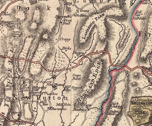 J5SD59SE.jpg "Hill Top / Mr. Robinson" house item:- National Library of Scotland : EME.s.47 Image © National Library of Scotland |
|
|
|
||
| evidence:- | old map:- Cary 1789 (edn 1805) placename:- Hill Top |
|
| source data:- | Map, uncoloured engraving, Westmoreland, scale about 2.5 miles
to 1 inch, by John Cary, London, 1789; edition 1805.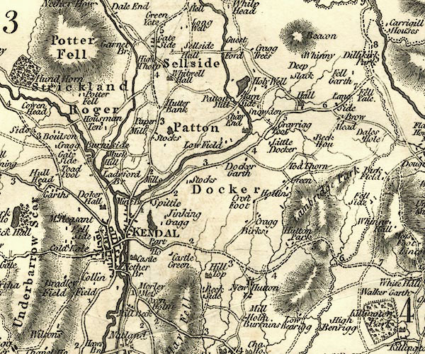 CY24SD59.jpg "Hill Top" house symbol; large house item:- JandMN : 129 Image © see bottom of page |
|
|
|
||
| evidence:- | road book:- Cary 1798 (2nd edn 1802) placename:- Hill Top |
|
| source data:- | Road book, itineraries, Cary's New Itinerary, by John Cary, 181
Strand, London, 2nd edn 1802. goto source goto source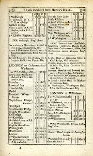 click to enlarge click to enlargeC38317.jpg page 317-318 "On r. about 2 Miles from Kendal is Hill Top, John Davison, Esq." item:- JandMN : 228.1 Image © see bottom of page |
|
|
|
||
| evidence:- | database:- Listed Buildings 2010 placename:- Holme Park School |
|
| source data:- | courtesy of English Heritage "HOLME PARK SCHOOL / / A684 / NEW HUTTON / SOUTH LAKELAND / CUMBRIA / II / 76693 / SD5477791206" |
|
| source data:- | courtesy of English Heritage "Large house, now school. Probably C18 core (appears on 1770 Westmorland map) remodelled early C19 (1809 date, with "SEWARD" above, painted on stained glass window commemorating Trafalgar in fanlight over porch door); later additions and alterations. Wet-dashed rubble. Graduated slate roofs. Mainly 2 storeys; house originally 9 bays overall and symmetrical. Central full height, flat-roofed, canted porch has panelled double door in architrave; windows sashes with glazing bars in architraves. Moulded cast iron guttering. Stone chimneys. Courtyard range adjoins west end of house; former single-storey billiard room adjoins east end. Interior is decorative with good plasterwork; curved stair has cast iron splats. Range of buildings adjoining to east of billiard room not of interest." |
|
|
|
||
Lakes Guides menu.