 Old Cumbria Gazetteer
 |
 |
|
| High Nest, Nest | ||
| High Nest | ||
| locality:- | Nest | |
| civil parish:- | St John's Castlerigg and Wythburn (formerly Cumberland) | |
| county:- | Cumbria | |
| locality type:- | buildings | |
| coordinates:- | NY29072279 | |
| 1Km square:- | NY2922 | |
| 10Km square:- | NY22 | |
| SummaryText:- | also see Nest | |
|
|
||
| evidence:- | old map:- OS County Series (Cmd 64 7) placename:- High Nest placename:- Nest, High |
|
| source data:- | Maps, County Series maps of Great Britain, scales 6 and 25
inches to 1 mile, published by the Ordnance Survey, Southampton,
Hampshire, from about 1863 to 1948. |
|
|
|
||
| evidence:- | possibly old text:- Clarke 1787 placename:- Pyat's Nest placename:- Magpy's Nest |
|
| source data:- | Guide book, A Survey of the Lakes of Cumberland, Westmorland,
and Lancashire, written and published by James Clarke, Penrith,
Cumberland, and in London etc, 1787; published 1787-93. goto source goto sourcePage 115:- "..." "Going along the lane called Castrigg Loning, which leads from the Druids temple to the top of the village of Castrigg, we come to a place called the Pyat's, (i.e. Magpy's) Nest: here we have a view of St John's chapel, ..." |
|
|
|
||
| evidence:- | possibly old map:- Clarke 1787 map (Ambleside to Keswick) placename:- Pyat Nest |
|
| source data:- | Map, A Map of the Roads Lakes etc between Keswick and Ambleside,
scale about 2.5 ins to 1 mile, by James Clarke, engraved by S J
Neele, 352 Strand, published by James Clarke, Penrith,
Cumberland and in London etc, 1787.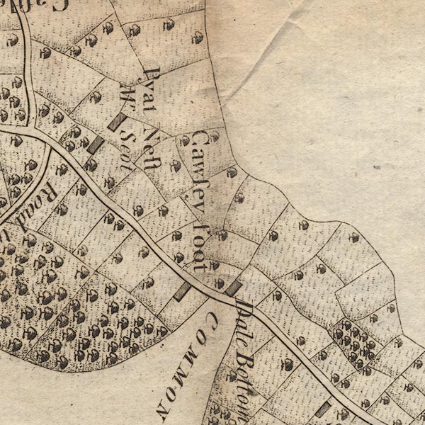 CL9NY22V.jpg "Pyat Nest / Mr Scot" item:- private collection : 10.9 Image © see bottom of page |
|
|
|
||
Lakes Guides menu.