 Old Cumbria Gazetteer
 |
 |
|
| High Hartsop Dodd, Patterdale | ||
| High Hartsop Dodd | ||
| civil parish:- | Patterdale (formerly Westmorland) | |
| county:- | Cumbria | |
| locality type:- | hill | |
| coordinates:- | NY39341076 | |
| 1Km square:- | NY3910 | |
| 10Km square:- | NY31 | |
| altitude:- | 1703 feet | |
| altitude:- | 519m | |
|
|
||
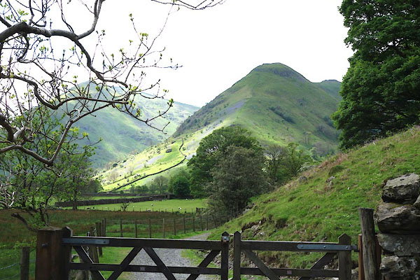 CAS56.jpg (taken 21.5.2014) 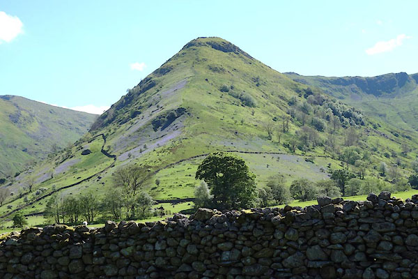 CAS55.jpg (taken 21.5.2014) |
||
|
|
||
| evidence:- | outline view:- Otley 1823 (4th edn 1830) placename:- Hartshop Dod |
|
| source data:- | Print, engraving, outline view, Mountains of Patterdale as seen from the Slate Quarry
on Place Fell, published by Jonathan Otley, Keswick, Cumberland et al, 1830.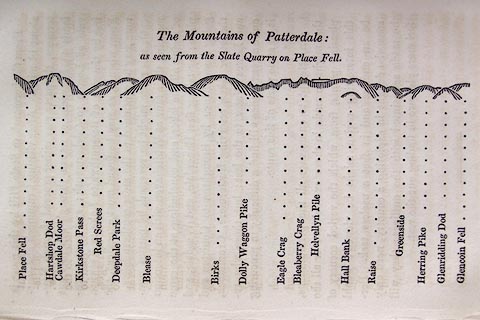 click to enlarge click to enlargeO75E10.jpg p.137 in A Concise Description of the English Lakes, by Jonathan Otley, 4th edition, 1830. "The Mountains of Patterdale: / as seen from the Slate Quarry on Place Fell." "Place Fell / Hartshop Dod / Cawdale Moor / Kirkstone Pass / Red Screes / Deepdale Park / Blease / Birks / Dolly Waggon Pike / Eagle Crag / Bleaberry Pike / Helvellyn Pile / Hall Bank / Raise / Greenside / Herring Pike / Glenridding Dod / Glencoin Fell" item:- Armitt Library : A1175.10 Image © see bottom of page |
|
|
|
||
| evidence:- | outline view:- Otley 1823 (8th edn 1849) placename:- Hartsop Dod |
|
| source data:- | Engraving, outline view of mountains, Mountains of Patterdale from the Slate Quarry
on Place Fell, drawn by T Binns, engraved by O Jewitt, opposite p.14 of A Descriptive
Guide of the English Lakes, by Jonathan Otley, 8th edition, 1849.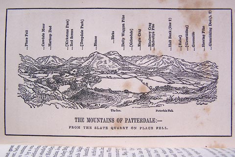 click to enlarge click to enlargeO80E08.jpg item:- Armitt Library : A1180.9 Image © see bottom of page |
|
|
|
||
| evidence:- | outline view:- Otley 1823 (5th edn 1834) placename:- Hartsop Dod |
|
| source data:- | Print, woodcut outline view, The Mountains of Patterdale, by
Jonathan Otley, Keswick, Cumberland, 1830.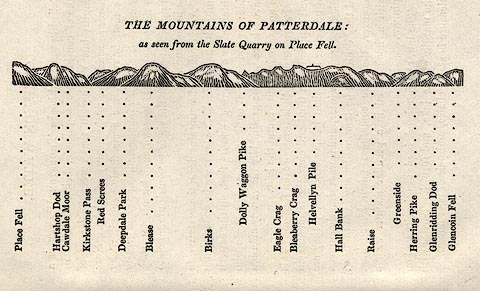 click to enlarge click to enlargeOT2E02.jpg Printed on p.11 of A Concise Description of the English Lakes, by Jonathan Otley, 5th edition, 1834. "THE MOUNTAINS OF PATTERDALE: as seen from the Slate Quarry on Place Fell." "Place Fell / Hartsop Dod / Cawdale Moor / Kirkstone Pass / Red Screes / Deepdale Park / Blease / Birks / Dolly Waggon Pike / Eagle Crag / Bleaberry Crag / Helvellyn Pile / Hall Bank / Raise / Greenside / Herring Pike / Glenridding Dod / Glencoin Fell" item:- JandMN : 48.3 Image © see bottom of page |
|
|
|
||
| evidence:- | perhaps outline view:- Tattersall 1836 (version 1869) placename:- Dod Fell |
|
| source data:- | Print, hand coloured, Upper Reach, Ullswater, Westmorland, drawn by George Tattersall,
1836, engraved by W F Topham, published by T J Allman, 463 Oxford Street, London,
1869.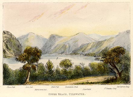 click to enlarge click to enlargeTAT218.jpg Included in The Lakes of England, by W F Topham. printed at bottom:- "UPPER REACH, ULLSWATER." printed at bottom:- "Place Fell. / Dod Fell. / Kirkstone Pass. / Birk Fell. / Patterdale Hall. / Fairfield. / St. Sunday Crag. / Stybarrow Crag." item:- Armitt Library : A1067.18 Image © see bottom of page |
|
|
|
||
| evidence:- | perhaps outline view:- Tattersall 1836 placename:- Dod Fell |
|
| source data:- | Print, engraving, Upper Reach, Ullswater, Westmorland, drawn by George Tattersall,
engraved by W F Topham, published by Sherwood and Co, Paternoster Row, London, about
1836.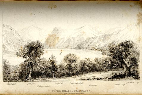 click to enlarge click to enlargeTAT142.jpg The print is captioned with mountain names and acts as an outline view. Tipped in opposite p.118 of The Lakes of England, by George Tattersall. printed at bottom:- "UPPER REACH, ULLSWATER. / [London Pubd. ...]" printed at bottom left to right:- "Place Fell. / Dod Fell. / Kirkstone Pass. / Birk Fell. / Patterdale Hall. / Fairfield. / St. Sunday Crag. / Stybarrow Crag." item:- Armitt Library : A1204.43 Image © see bottom of page |
|
|
|
||
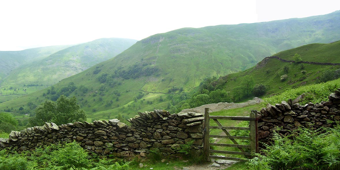 Click to enlarge BPH49.jpg (taken 9.6.2008) 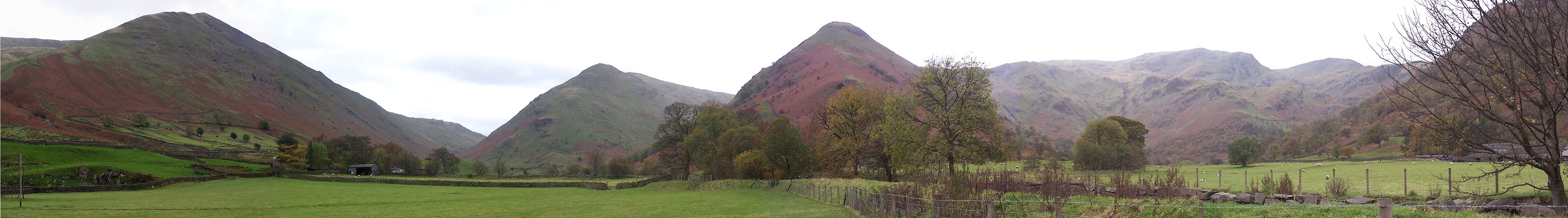 Click to enlarge BMY53.jpg Panorama from the track to Hartsop Hall; Caudale Moor, Kirkstone Pass, Middle Dodd, High Hartsop Dodd, Stand Crags and Dove Crag in Dovedale. (taken 5.11.2006) |
||
|
|
||
 Lakes Guides menu.