 Old Cumbria Gazetteer
 |
 |
|
| High Blaithwaite Station, Boltons | ||
| Blaithwaite Siding | ||
| High Blaithwaite Station | ||
| site name:- | Maryport and Carlisle Railway | |
| locality:- | High Blaithwaite | |
| locality:- | Blaithwaite | |
| civil parish:- | Boltons (formerly Cumberland) | |
| county:- | Cumbria | |
| locality type:- | railway station | |
| locality type:- | railway sidings | |
| locality type:- | coal depot | |
| coordinates:- | NY22434422 | |
| 1Km square:- | NY2244 | |
| 10Km square:- | NY24 | |
| SummaryText:- | Opened 1866; closed 1921. | |
|
|
||
| evidence:- | old map:- OS County Series (Cmd 36 4) placename:- Blaithwaite Siding item:- weighing machine |
|
| source data:- | Maps, County Series maps of Great Britain, scales 6 and 25
inches to 1 mile, published by the Ordnance Survey, Southampton,
Hampshire, from about 1863 to 1948.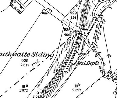 click to enlarge click to enlargeCSRY0048.jpg "Blaithwaite Siding / Coal Depot / W.M." |
|
|
|
||
 Lakes Guides menu.