

placename:- Helvellyn Mine
item:- lead ore; galena; Arnison's Level; No.1 Level; No.2 Level; No.3 Level; No.4 Level; tramways; self acting tramroad; inclined plane; Manchester Corporation Waterworks
 goto source
page 126:- "HELVELLYN MINE."
"This mine is situated on the western side of Helvellyn, near the head of Lake Thirlmere. It embraces two north-north-east and south-south-west veins, and an east-north-east and west-south-west cross course. The veins are generally large, but hard and compact; and the ore (galena) which they contain, is usually very much interspersed through the vein-stone. Several Elvanite dykes have been met with in these workings."
"Five adit levels have been driven on these veins, namely, Arnison's level, and Nos.1, 2, 3, and 4 levels. A great deal of ground has been explored and laid open, and a little ore raised. The ore has been obtained chiefly in the upper part of the mine, in Arnison's and No.1 levels, at the points where the north-north-east and south-south-west veins are intersected by the east and west vein."
"The mine was taken up about fifty years ago by an enterprising Company, who expended about L20,000 in opening and developing it, in erecting the necessary crushing and dressing"
 goto source
page 127:- "machinery, and constructing a self-acting inclined tramway 600 yards in length, by which the ore was brought down to the dressing floors. The operations of this Company extended over about thirteen years, and during that time the various adit levels were driven an aggregate distance of 630 fathoms, and about 300 tons of ore were raised, worth L4,000. The quantity of ore is small compared with the extent of ground explored, and this want of success caused many of the shareholders to retire from the undertaking; some of them, however, were full of confidence, and resolved, if possible, to bring it to a successful issue. These gentlemen succeeded in forming a fresh Company, and after a short interval, recommenced operations, but the whole of the land on which the mine is situated was acquired by the Manchester Corporation for their waterworks, and all further mining operations were brought to an end in 1880."

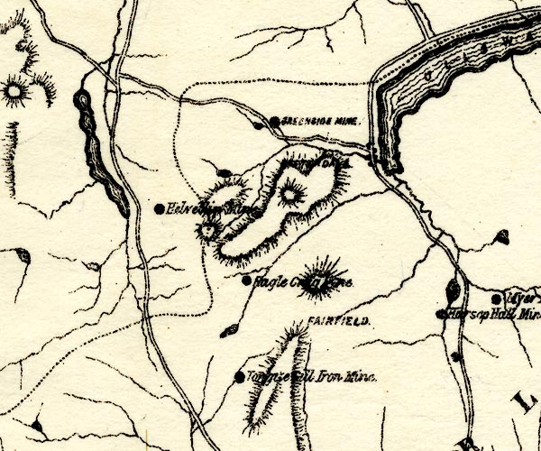
PST2NY31.jpg
"Helve[ll M]ine"
mine symbol
item:- JandMN : 162.2
Image © see bottom of page
placename:- Helvellyn Consols Mine
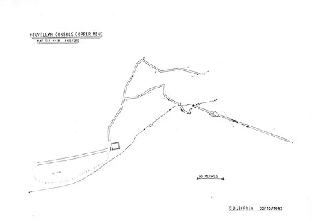
placename:- Helvellyn Consols Copper Mine
item:- copper pyrites; malachite; quartz tuff
Geological Outing of the Kendal and District Mine Research Society
Log book page 55:- "DATE - 11/5/80 / MAP REF - 3300/1270 (NY31) / LOCATION - HELVELLYN / NAME - HELVELLYN CONSOLS MINE / TYPE OF SITE - MINE / WORKING OR DISUSED - DISUSED. / PEOPLE IN PARTY [ ] / NOS. OF PHOTOS - 31 / SPECIMENS FOUND - HALF BRICK SIZE PIECES OF COPPER PYRITES, SMALL PIECES OF MALACHITE & QUARTZ TUFF. / COMMENTS - VERY WARM DAY, WINDY. MINE IN WATER FOR FIRST 100FT OR SO, THEN FAIRLY DRY, LOTS OF COPPER PYRITES & MALACHITE IN WALLS ROOF &FLOOR, AND SOME GOOD SPECIMENS WERE COLLECTED. FURTHER UP THE BECK ON THE RIGHT IS A SHAFT OF APPROX 30FT. AND A LEVEL CAN BE SEEN AT THE BOTTOM. [sketch]"
Log book page 102:- "DATE - 30/8/81 / MAP REF - / LOCATION - / NAME - HELVELLYN CONSOLS / TYPE OF SITE - / WORKING OR DISUSED - / PEOPLE IN PARTY [ ] / NOS. OF PHOTOS - / SPECIMENS FOUND - / COMMENTS - AS 11/5/80 + DECENDED (sic) SHAFT 30FT APPROX. THE SHAFT WAS, AT ONE TIME, CONNECTED WITH THE REST OF THE MINE BUT IS NOW BLOCKED BY A ROOF FALL ON ONE SIDE. THE OTHER SIDE OF THIS SHAFT ENTERS INTO A LEVEL AND ANOTHER SHAFT IS ENCOUNTERED IN THE FLOOR AFTER A FEW YARDS, THIS IS FULL OF WATER AND IS JUST PASSABLE WITH CARE. A SMALL AMOUNT OF STOPING IS SEEN, BUT THE LEVEL DOES NOT EXTEND VERY FAR AND ENDS IN A ROCK FACE. [small sketch]"
otherwise:- "AS 11/5/80"
item:- private collection : 82
Image © see bottom of page
placename:- Helvellyn Consols Copper Mine
 click to enlarge
KMR32.jpg
"HELVELLYN CONSOLS COPPER MINE"
item:- private collection : 82
Image © see bottom of page
