 Old Cumbria Gazetteer
 |
 |
|
| Hardrigg Hall, Skelton | ||
| Hardrigg Hall | ||
| Hardrigg Castle | ||
| civil parish:- | Skelton (formerly Cumberland) | |
| county:- | Cumbria | |
| locality type:- | buildings | |
| locality type:- | pele tower | |
| coordinates:- | NY42483618 | |
| 1Km square:- | NY4236 | |
| 10Km square:- | NY43 | |
|
|
||
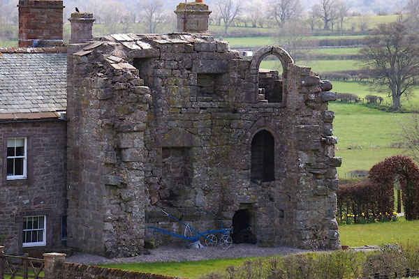 CEW83.jpg Pele. (taken 22.4.2016) 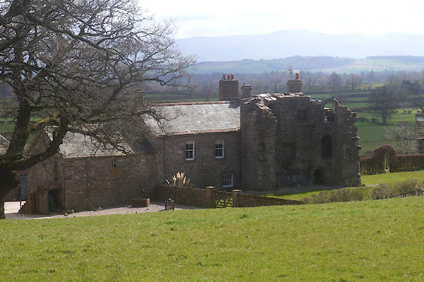 CEW82.jpg (taken 22.4.2016) |
||
|
|
||
| evidence:- | old map:- OS County Series (Cmd 49 5) placename:- Hardrigg Hall |
|
| source data:- | Maps, County Series maps of Great Britain, scales 6 and 25
inches to 1 mile, published by the Ordnance Survey, Southampton,
Hampshire, from about 1863 to 1948. |
|
|
|
||
| evidence:- | old map:- Saxton 1579 placename:- Hareridge Hall |
|
| source data:- | Map, hand coloured engraving, Westmorlandiae et Cumberlandiae Comitatus ie Westmorland
and Cumberland, scale about 5 miles to 1 inch, by Christopher Saxton, London, engraved
by Augustinus Ryther, 1576, published 1579-1645.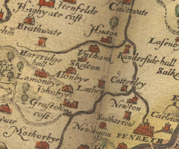 Sax9NY43.jpg Tower, symbol for a house, hall, tower, etc. "Hareridge hall" item:- private collection : 2 Image © see bottom of page |
|
|
|
||
| evidence:- | old map:- Speed 1611 (Cmd) placename:- Hareridge Hall |
|
| source data:- | Map, hand coloured engraving, Cumberland and the Ancient Citie
Carlile Described, scale about 4 miles to 1 inch, by John Speed,
1610, published by J Sudbury and George Humble, Popes Head
Alley, London, 1611-12.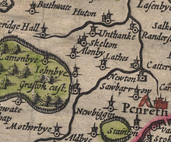 SP11NY43.jpg "Hareridge Hall" circle, tower item:- private collection : 16 Image © see bottom of page |
|
|
|
||
| evidence:- | old map:- Jansson 1646 placename:- Hareridge Hall |
|
| source data:- | Map, hand coloured engraving, Cumbria and Westmoria, ie
Cumberland and Westmorland, scale about 3.5 miles to 1 inch, by
John Jansson, Amsterdam, Netherlands, 1646.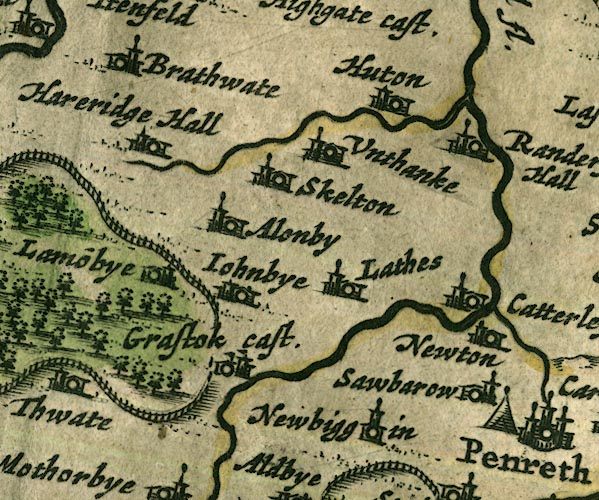 JAN3NY43.jpg "Hareridge Hall" Buildings and tower. item:- JandMN : 88 Image © see bottom of page |
|
|
|
||
| evidence:- | old map:- Morden 1695 (Cmd) placename:- Hareridg Hall |
|
| source data:- | Map, uncoloured engraving, Cumberland, scale about 4 miles to 1
inch, by Robert Morden, 1695, published by Abel Swale, the
Unicorn, St Paul's Churchyard, Awnsham, and John Churchill, the
Black Swan, Paternoster Row, London, 1695-1715.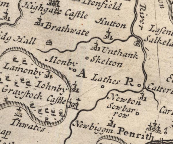 MD12NY43.jpg "Hareridg Hall" Drawing of a house. item:- JandMN : 90 Image © see bottom of page |
|
|
|
||
| evidence:- | old map:- Bowen and Kitchin 1760 placename:- Hareridge Hall |
|
| source data:- | Map, hand coloured engraving, A New Map of the Counties of
Cumberland and Westmoreland Divided into their Respective Wards,
scale about 4 miles to 1 inch, by Emanuel Bowen and Thomas
Kitchin et al, published by T Bowles, Robert Sayer, and John
Bowles, London, 1760.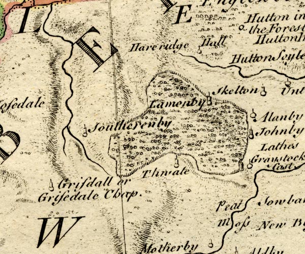 BO18NY33.jpg "Hareridge Hall" circle and line item:- Armitt Library : 2008.14.10 Image © see bottom of page |
|
|
|
||
| evidence:- | old map:- Donald 1774 (Cmd) placename:- Hardrigg Hall |
|
| source data:- | Map, hand coloured engraving, 3x2 sheets, The County of Cumberland, scale about 1
inch to 1 mile, by Thomas Donald, engraved and published by Joseph Hodskinson, 29
Arundel Street, Strand, London, 1774.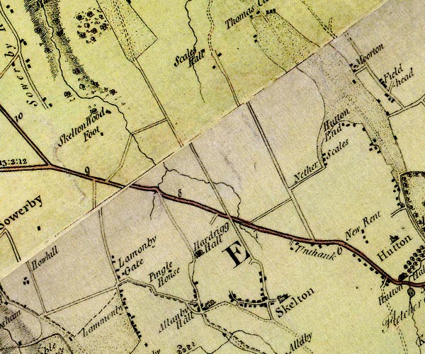 D4NY43NW.jpg "Hardrigg Hall" house item:- Carlisle Library : Map 2 Image © Carlisle Library |
|
|
|
||
| evidence:- | database:- Listed Buildings 2010 placename:- Hardrigg Hall Farm |
|
| source data:- | courtesy of English Heritage "HARDRIGG HALL FARMHOUSE, WITH TOWER, BARN AND STABLES ADJOINING / / / SKELTON / EDEN / CUMBRIA / II / 73944 / NY4248836183" |
|
|
|
||
| evidence:- | database:- Listed Buildings 2010 |
|
| source data:- | courtesy of English Heritage "FORMER BARN 30 METRES TO SOUTH WEST OF HARDRIGG HALL / / / SKELTON / EDEN / CUMBRIA / II / 74016 / NY4251536150" |
|
|
|
||
| notes:- |
14th century tower, in ruins |
|
| Perriam, D R &Robinson, J: 1998: Medieval Fortified Buildings of Cumbria: CWAAS::
ISBN 1 873124 23 6 |
||
|
|
||
 Lakes Guides menu.