 Old Cumbria Gazetteer
 |
 |
|
| Grey Crag, Longsleddale | ||
| Grey Crag | ||
| civil parish:- | Longsleddale (formerly Westmorland) | |
| county:- | Cumbria | |
| locality type:- | hill | |
| coordinates:- | NY48700659 (?) | |
| 1Km square:- | NY4806 | |
| 10Km square:- | NY40 | |
| altitude:- | 2093 feet | |
| altitude:- | 638m | |
|
|
||
| evidence:- | old map:- OS County Series (Wmd 27 3) placename:- Grey Crag |
|
| source data:- | Maps, County Series maps of Great Britain, scales 6 and 25
inches to 1 mile, published by the Ordnance Survey, Southampton,
Hampshire, from about 1863 to 1948. Shown as a Trigonometrical Station. |
|
|
|
||
| evidence:- | old map:- Hodgson 1828 placename:- Grey Crag |
|
| source data:- | Map, hand coloured engraving, 4 sheets mounted together on linen and rolled, Plan
of the County of Westmorland, scale about 1.25 inches to 1 mile, by Thomas Hodgson,
engraved by W R Gardner, Harpur Street, London, published by Thomas Hodgson, Lancaster,
and perhaps by C Smith, 172 Strand, London,1828.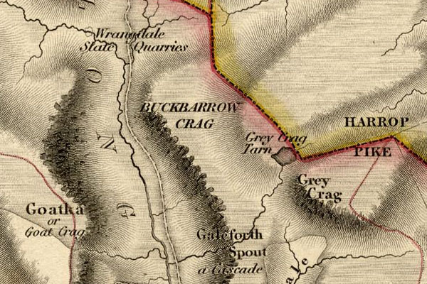 HDG6lsl4.jpg map courtesy of Mark Cropper "Grey Crag" item:- private collection : 371 Image © see bottom of page |
|
|
|
||
 Kendal Corn Rent Act 1836 Kendal Corn Rent Act 1836 |
||
|
|
||
| evidence:- | old map:- OS 1881-82 New Series (outline edition) placename:- Grey Crag |
|
| source data:- | Map, engraving, area north of Kendal, Westmorland, New Series
one inch map, outline edition, sheet 39, scale 1 inch to 1 mile,
published by the Ordnance Survey, Southampton, Hampshire,
1881-82.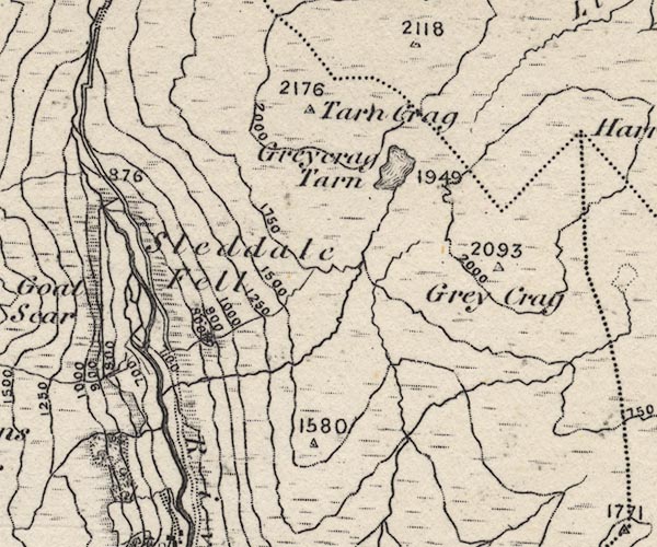 O21NY40Y.jpg , "Grey Crag / 2093" item:- JandMN : 61 Image © see bottom of page |
|
|
|
||
| evidence:- | descriptive text:- Wilson 1912 |
|
| source data:- | Guide book, Longsleddale, by F M Wilson, published by T Wilson,
Kendal, Westmorland, 1912. WILSON1.txt "... It is only a few years since the last of the large vulture tribe was shot somewhere about Grey Crag." |
|
|
|
||
| evidence:- | records:- Farrer and Curwen 1923 placename:- Gray Crag item:- demise; sheep; stone wall; fence; barn |
|
| source data:- | Records Relating to the Barony of Kendale, edited by William
Farrer and John F Curwen, published by Titus Wilson and Son,
Kendal, Westmorland, 1923. "1669 : Demise dated 2 February, 1669, from Alan Bellingham of Over Levens, esq., to Richard Lickbarrow of Longsleddall, yeoman, of all his pastures, meadows and commons called Gray Crag and Iron Craw "together with all the sheep heafes and the barne there," to hold for one year for £10 rent to be paid on 11 November; with covenants that the tenant maintain the walls and fences, "thack" and keep up the barn, and that the said Richard Lickbarrow shall have his ewes to pasture there until 15 April after the expiration of the term and such "gelt" sheep as he may require; D. at Levens." |
|
|
|
||
| evidence:- | records:- Farrer and Curwen 1923 placename:- Graycragg placename:- Graycrage item:- rent; turbary |
|
| source data:- | Records Relating to the Barony of Kendale, edited by William
Farrer and John F Curwen, published by Titus Wilson and Son,
Kendal, Westmorland, 1923. "1579 : James Layburne, esq., conveys by fine to Thomas Bellingham, esq., 30 messuages &c. and lands in Sleddall, Stockdall, Swinkelbancke, Sadgyllthwaite, Sadgyllhead, Stockdallhead, Sleddallhead, Graycragg, Arnecrewe and Towside; Reg. of D. at Levens." ": Indentures of bargain and sale dated 13 March, 21 Elizabeth (1579), made between James Laburne of Skellesmerghe, esq., and Thomas Bellingham of the Myddell Temple, London, esq., reciting that in consideration of £800 the vendor conveys to the purchaser his lands, tenements, wastes, heaths, moors, turbaries &c., known as Graycrage, Arncrooe, Towsyde, Scleddalhede, situate in the townships or hamlets of Scleddall, Stokdall, Sadgill and Sadgilhed, late in the tenure of the said James Laburne, and all these messuages, tenements, lands &c. in Scleddall, Stokdall, Swynkelbanck and Arncrooe in the occupation of [the tenants named in the ensuing rental]; ib." |
|
|
|
||
| evidence:- | textbook:- EPNS Westmorland 1967 placename:- Graycragg placename:- Grai Cragg |
|
| source data:- | Book, The Place Names of Westmorland, two volumes, by A H Smith,
published for the English Place Name Society by Cambridge
University Press, Cambridgeshire, 1967 |
|
|
|
||
| evidence:- | map:- OS Six Inch (1956) placename:- Grey Crag |
|
| source data:- | Map series, various editions with the national grid, scale about
6 inches to 1 mile, published by the Ordnance Survey,
Southampton, Hampshire, scale 1 to 10560 from 1950s to 1960s,
then 1 to 10000 from 1960s to 2000s, superseded by print on
demand from digital data.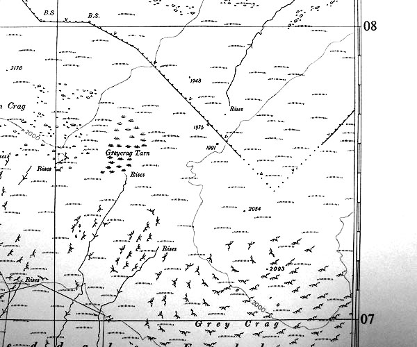 SINY4907.jpg "Grey Crag / 2093" |
|
|
|
||
| notes:- |
There is a bield called Stockdale Bield on the crag. And a levelled area with traces
of a building. |
|
| : 2009: Archaeological Data Service &ADS |
||
|
|
||
 Lakes Guides menu.