 Old Cumbria Gazetteer
 |
 |
|
| Greenthwaite Hall, Greystoke | ||
| Greenthwaite Hall | ||
| Street:- | Berrier Road | |
| civil parish:- | Greystoke (formerly Cumberland) | |
| county:- | Cumbria | |
| locality type:- | buildings | |
| coordinates:- | NY43153021 | |
| 1Km square:- | NY4330 | |
| 10Km square:- | NY43 | |
|
|
||
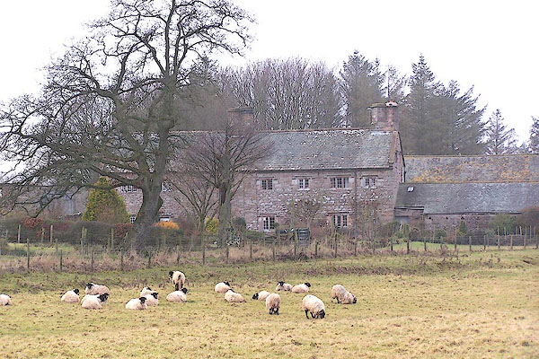 BLP50.jpg (taken 4.2.2006) |
||
|
|
||
| evidence:- | old map:- OS County Series (Cmd 58 1) placename:- Greenthwaite Hall |
|
| source data:- | Maps, County Series maps of Great Britain, scales 6 and 25
inches to 1 mile, published by the Ordnance Survey, Southampton,
Hampshire, from about 1863 to 1948. |
|
|
|
||
| evidence:- | old map:- Saxton 1579 placename:- Thwate |
|
| source data:- | Map, hand coloured engraving, Westmorlandiae et Cumberlandiae Comitatus ie Westmorland
and Cumberland, scale about 5 miles to 1 inch, by Christopher Saxton, London, engraved
by Augustinus Ryther, 1576, published 1579-1645.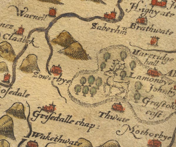 Sax9NY33.jpg Building, symbol for a hamlet, which may or may not have a nucleus. "Thwate" item:- private collection : 2 Image © see bottom of page |
|
|
|
||
| evidence:- | possibly old map:- Mercator 1595 (edn?) placename:- Thwate |
|
| source data:- | Map, hand coloured engraving, Northumbria, Cumberlandia, et
Dunelmensis Episcopatus, ie Northumberland, Cumberland and
Durham etc, scale about 6.5 miles to 1 inch, by Gerard Mercator,
Duisberg, Germany, about 1595.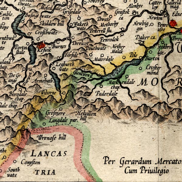 MER8CumF.jpg "Thwate" circle item:- JandMN : 169 Image © see bottom of page |
|
|
|
||
| evidence:- | old map:- Speed 1611 (Cmd) placename:- Thwate |
|
| source data:- | Map, hand coloured engraving, Cumberland and the Ancient Citie
Carlile Described, scale about 4 miles to 1 inch, by John Speed,
1610, published by J Sudbury and George Humble, Popes Head
Alley, London, 1611-12.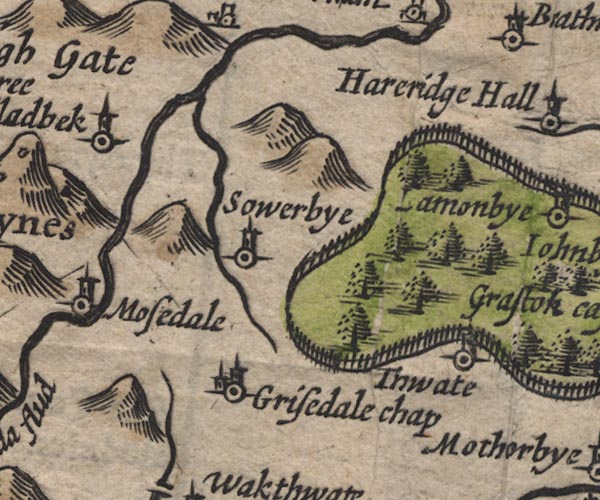 SP11NY33.jpg "Thwate" circle, tower item:- private collection : 16 Image © see bottom of page |
|
|
|
||
| evidence:- | old map:- Jansson 1646 placename:- Thwate |
|
| source data:- | Map, hand coloured engraving, Cumbria and Westmoria, ie
Cumberland and Westmorland, scale about 3.5 miles to 1 inch, by
John Jansson, Amsterdam, Netherlands, 1646.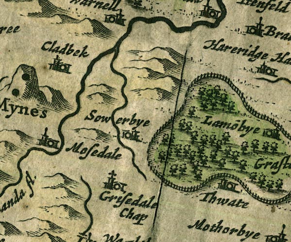 JAN3NY33.jpg "Thwate" Buildings and tower. item:- JandMN : 88 Image © see bottom of page |
|
|
|
||
| evidence:- | old map:- Morden 1695 (Cmd) placename:- Thwates |
|
| source data:- | Map, uncoloured engraving, Cumberland, scale about 4 miles to 1
inch, by Robert Morden, 1695, published by Abel Swale, the
Unicorn, St Paul's Churchyard, Awnsham, and John Churchill, the
Black Swan, Paternoster Row, London, 1695-1715.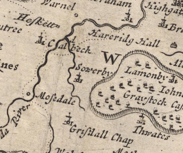 MD12NY33.jpg "Thwates" Circle, building and tower. item:- JandMN : 90 Image © see bottom of page |
|
|
|
||
| evidence:- | old map:- Donald 1774 (Cmd) placename:- Greenthwaite Hall |
|
| source data:- | Map, hand coloured engraving, 3x2 sheets, The County of Cumberland, scale about 1
inch to 1 mile, by Thomas Donald, engraved and published by Joseph Hodskinson, 29
Arundel Street, Strand, London, 1774.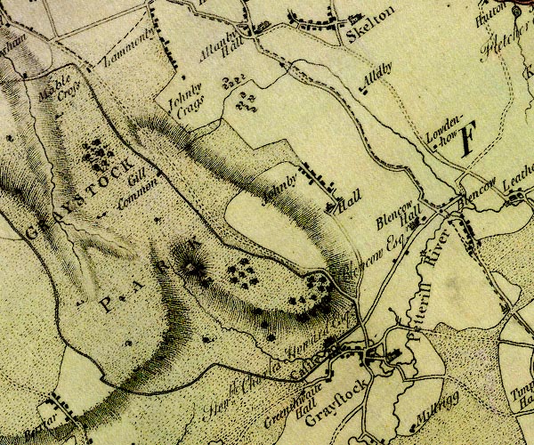 D4NY43SW.jpg "Greenthwaite Hall" block or blocks, labelled in lowercase; a hamlet or just a house item:- Carlisle Library : Map 2 Image © Carlisle Library |
|
|
|
||
| evidence:- | old print:- Taylor 1892 placename:- Greenthwaite Hall |
|
| source data:- | Print, plan of Greenthwaite Hall, Greystoke, Cumberland, published for the Cumberland
and Westmorland Antiquarian and Archaeological Society, by Titus Wilson, Kendal, Westmorland,
and by Charles Thurnam and Sons, Carlisle, Cumberland, 1892.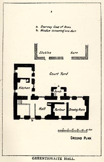 click to enlarge click to enlargeTY5068.jpg Tipped in opposite p.304 of The Old Manorial Halls of Cumberland and Westmorland, by Michael Waistell Taylor. item:- Armitt Library : A785.68 Image © see bottom of page |
|
|
|
||
| evidence:- | old print:- Taylor 1892 placename:- Greenthwaite Hall item:- coat of arms; date stone (1650) |
|
| source data:- | Print, halftone photograph, Greenthwaite Hall, Greystoke, Cumberland, published for
the Cumberland and Westmorland Antiquarian and Archaeological Society, by Titus Wilson,
Kendal, Westmorland, and by Charles Thurnam and Sons, Carlisle, Cumberland, 1892.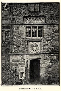 click to enlarge click to enlargeTY5069.jpg Inscription on the lintel - '[PEREGRINOS HIC NOS / REPUTAMUS 1650 / H / M D]' for Miles and Dorothy Halton. Tipped in opposite p.305 of The Old Manorial Halls of Cumberland and Westmorland, by Michael Waistell Taylor. item:- Armitt Library : A785.69 Image © see bottom of page |
|
|
|
||
| evidence:- | old print:- Curwen 1913 item:- coat of arms; Halton Family; Halton, Miles item:- date stone (1650); 1650s; H, M and D; MandDH |
|
| source data:- | Print, uncoloured lithograph, lintel, coats of arms and date stone, Greenthwaite Hall,
Greystoke, Cumberland, published for the Cumberland and Westmorland Antiquarian and
Archaeological Society by Titus Wilson, Kendal, Westmorland, 1913.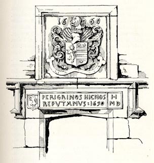 click to enlarge click to enlargeCW0191.jpg Halton Family coat of arms; date stone 'PERIGRINOS HIC NOS / REPUTAMUS 1650 / H / M D', translated as 'Here we consider ourselves pilgrims'. On p.441 of The Castles and Fortified Towers of Cumberland, Westmorland, and Lancashire North of the Sands, by John F Curwen. item:- Armitt Library : A782.91 Image © see bottom of page |
|
|
|
||
| evidence:- | database:- Listed Buildings 2010 placename:- Greenthwaite Hall Farm item:- date stone (1650) |
|
| source data:- | courtesy of English Heritage "GREENTHWAITE HALL FARMHOUSE / / BERRIER ROAD / GREYSTOKE / EDEN / CUMBRIA / II[star] / 73812 / NY4315430207" |
|
|
|
||
| notes:- |
the present hall replaces a medieval hall |
|
| Perriam, D R &Robinson, J: 1998: Medieval Fortified Buildings of Cumbria: CWAAS::
ISBN 1 873124 23 6; plan |
||
|
|
||
 Lakes Guides menu.