 Old Cumbria Gazetteer
 |
 |
|
| Greensett Caves, North Yorkshire | ||
| Greensett Caves | ||
| site name:- | Whernside | |
| county:- | North Yorkshire | |
| locality type:- | cave | |
| coordinates:- | SD747821 | |
| 1Km square:- | SD7482 | |
| 10Km square:- | SD78 | |
| altitude:- | 1825 feet | |
| altitude:- | 556m | |
| SummaryText:- | Stream system in the Main Limestone, various entrances. Explored by Yorkshire Ramblers Club, 1912; further by White Rose Pothole Club, 1968; and Craven Poyhole Club, 1972. | |
| SummaryText:- | Grade II. | |
| references:- | Brook, D & Davies, G & Long, M H &Sutcliffe, J R: 1975: Northern Caves, vol.4 Whernside
and Gragareth: Dalesman Books:: ISBN 0 85206 259 1 |
|
|
|
||
| evidence:- | descriptive text:- West 1778 (11th edn 1821) placename:- Greenside Cave |
|
| source data:- | Guide book, A Guide to the Lakes, by Thomas West, published by
William Pennington, Kendal, Cumbria once Westmorland, and in
London, 1778 to 1821. goto source goto sourceTour to the Caves in the West Riding of Yorkshire, late 18th century Page 269:- "..." "Having ... passed through the little remote village of Winterscales, we came to the natural curiosity we were in quest of, Greenside-Cave: it is under the south-east corner of the lofty mountain Whernside. The mouth was wide and high, and the road rugged; but the roof gradually sunk, or the bottom arose, till it was troublesome getting along soon after we were out of the sight of day. A small brook ran along the bottom, as in the other caves; but there were none of the curious petrifactions we saw in most of them, to delight the eye. Churchill's description of the Caledonian cave of Famine, with a few alterations will convey a just idea of Greenside-Cave.-" "This lonely cave (hard tax on Scottish pride!) / Shelter at once for man and beast supply'd. / Their snares without, entangling briers spread, / And thistles arm'd against the' invader's tread: / Here webs were spread of more than common size, / And half-starv'd spiders prey'd on half-starv'd flies. / In quest of food, efts strove in vain to crawl: / Slugs, pinch'd with hunger, smear'd the slimy wall. / The cave around with falling riv'lets rung, / And on the roof unhealthy vapours hung." "Near the mouth of this cave is a thin stratum of coal, not many inches thick. Some attempts have been made to work it, but affording so small gains, and the inhabitants being so" goto sourcePage 270:- "well supplied with this article from Ingleton, it was soon deserted.- ..." |
|
|
|
||
| evidence:- | descriptive text:- Balderston c1890 placename:- Greensett Cave placename:- Hagtorn Cave |
|
| source data:- | Book, Ingleton, Bygone and Present, by Robert R and Margaret
Balderston, published by Simpkin, Marshall and Co, London, and
by Edmndson and Co, 24 High Street, Skipton, Yorkshire, about
1890. goto source page 77:- "..." "Greensett, or Hagtorn Cave." "The same stream [Force Gill] issues some distance above from the base of a rock of the upper limestone series, at an elevation of at least 1800 feet. There is a kind of rocky gully just below the mouth, with boulders scattered about; the entrance is low, owing to a profusion of loose rock which partly blocks the way; within, however, the cave is wide and spacious, and for sixty-seven yards progress is easy. At this point the passage bifurcates, being low and wide to the north, lofty and a mere rift to the west, with water unpleasantly abundant." |
|
|
|
||
| evidence:- | old map:- Balderston c1890 map placename:- Greensett Cave |
|
| source data:- | Map, the hills in the Ingleton area, probably by Robert R
Balderston, engraved by Goodall and Suddick, Leeds, West
Yorkshire, about 1890.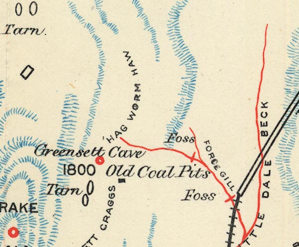 BS1SD78L.jpg "Greensett Cave" item:- private collection : 27.1 Image © see bottom of page |
|
|
|
||
Lakes Guides menu.