 Old Cumbria Gazetteer
 |
 |
|
||||||||||||||||||||||||||||
| Great Gable, Nether Wasdale | ||||||||||||||||||||||||||||||
| Great Gable | ||||||||||||||||||||||||||||||
| civil parish:- | Nether Wasdale (formerly Cumberland) | |||||||||||||||||||||||||||||
| civil parish:- | Borrowdale (formerly Cumberland) | |||||||||||||||||||||||||||||
| county:- | Cumbria | |||||||||||||||||||||||||||||
| locality type:- | hill | |||||||||||||||||||||||||||||
| coordinates:- | NY21101034 | |||||||||||||||||||||||||||||
| 1Km square:- | NY2110 | |||||||||||||||||||||||||||||
| 10Km square:- | NY21 | |||||||||||||||||||||||||||||
| altitude:- | 2949 feet | |||||||||||||||||||||||||||||
| altitude:- | 899m | |||||||||||||||||||||||||||||
|
|
||||||||||||||||||||||||||||||
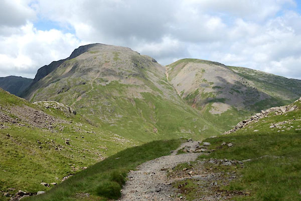
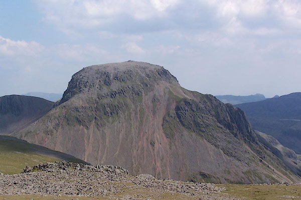 BUX33.jpg (taken 4.7.2011) 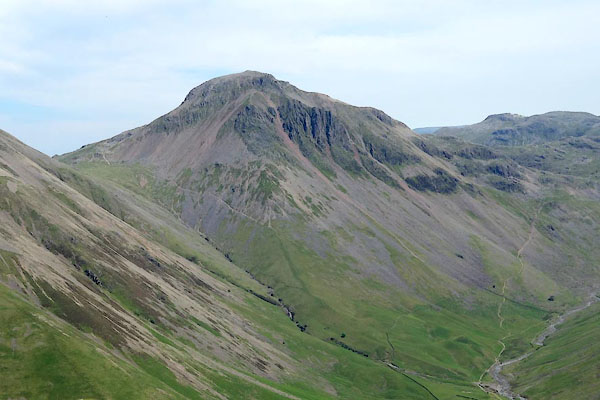 BYO62.jpg (taken 18.6.2013) |
||||||||||||||||||||||||||||||
|
|
||||||||||||||||||||||||||||||
| evidence:- | old map:- OS County Series (Cmd 74 8) placename:- Great Gable placename:- Gable, Great |
|||||||||||||||||||||||||||||
| source data:- | Maps, County Series maps of Great Britain, scales 6 and 25
inches to 1 mile, published by the Ordnance Survey, Southampton,
Hampshire, from about 1863 to 1948. |
|||||||||||||||||||||||||||||
|
|
||||||||||||||||||||||||||||||
| evidence:- | old painting:- Green 1790s-1820s (1822) |
|||||||||||||||||||||||||||||
| source data:- | Painting, watercolour, Great Gable and Wast Water from Overbeck Bridge, Nether Wasdale,
Cumberland, by William Green, Ambleside, Westmorland, 1822.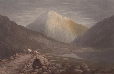 click to enlarge click to enlargePR1752.jpg item:- Dove Cottage : 2010.57.1 Image © see bottom of page |
|||||||||||||||||||||||||||||
|
|
||||||||||||||||||||||||||||||
| evidence:- | old text:- Green 1810 placename:- Gable |
|||||||||||||||||||||||||||||
| source data:- | Set of prints, soft ground etchings, Sixty Studies from Nature,
by William Green, Ambleside, Westmorland, drawn 1808-10,
published 1810. goto source goto sourcepage 90:- "..." "Mountains frequently appear high or low proportionately to the quantity of surface disclosed to the eye; thus, Gable, which is only outtopped by Scho-fell, from the highest houses at Wastdale Head, does not appear a high mountain, because a line drawn from the eye of the spectator to its summit will subtend with the surface of the mountain a very acute angle, perhaps not more than ten degrees; and were it not for perspective diminution and atmospheric density, Gable would not appear higher than any other moun-" page 91:- "[moun]tain, having its altitude in any part of the line drawn from the eye to the summit of Gable." "Ascend from this place to Sty Head, which is a great height, and here Gable, displaying more superficies, appears much higher than it does from the houses; but rise to the top of Sprinkling, and it will appear to the spectator's horizon much higher than it did even from the Sty; though the Sty is perhaps not more than half the perpendicular height of Sprinkling above the level of the valley." |
|||||||||||||||||||||||||||||
|
|
||||||||||||||||||||||||||||||
| evidence:- | old print:- Green 1814 (plate 44) |
|||||||||||||||||||||||||||||
| source data:- | Print, tinted soft ground etching, Wast Water from the Road, Nether Wasdale, Cumberland,
by William Green, Ambleside, Westmorland, 1814.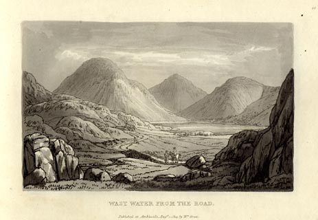 click to enlarge click to enlargeGN1044.jpg Plate 44 in Sixty Small Prints. printed at top right:- "44" printed at bottom:- "WAST WATER FROM THE ROAD. / Published at Ambleside Augst. 1, 1814, by Wm. Green." item:- Armitt Library : A6653.44 Image © see bottom of page |
|||||||||||||||||||||||||||||
|
|
||||||||||||||||||||||||||||||
| evidence:- | old print:- Green 1814 (plate 44) |
|||||||||||||||||||||||||||||
| source data:- | Print, uncoloured soft ground etching, Wast Water from the Road, Nether Wasdale, Cumberland,
by William Green, Ambleside, Westmorland, 1814.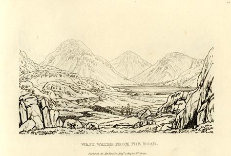 click to enlarge click to enlargeGN0944.jpg Plate 44 in Sixty Small Prints. printed at top right:- "44" printed at bottom:- "WAST WATER FROM THE ROAD. / Published at Ambleside Augst. 1, 1814, by Wm. Green." item:- Armitt Library : A6656.44 Image © see bottom of page |
|||||||||||||||||||||||||||||
|
|
||||||||||||||||||||||||||||||
| evidence:- | old text:- Green 1814 placename:- Great Gable item:- placename |
|||||||||||||||||||||||||||||
| source data:- | Set of prints, soft ground etchings, Sixty Small Prints, with
text, A Description of a Series of Sixty Small Prints, by
William Green, Ambleside, Westmorland, 1814. goto source page 26:- "... Great Gable, so called from its resemblance to the roof of a house. ..." |
|||||||||||||||||||||||||||||
|
|
||||||||||||||||||||||||||||||
| evidence:- | old print with text:- Farington 1816 placename:- Great Gable |
|||||||||||||||||||||||||||||
| source data:- | Print, uncoloured engraving and descriptive text, Wastdale Village, Nether Wasdale,
Cumberland, drawn by Joseph Farington, engraved by J Landseer, published by T Cadell
and W Davies, Strand, London, 1815.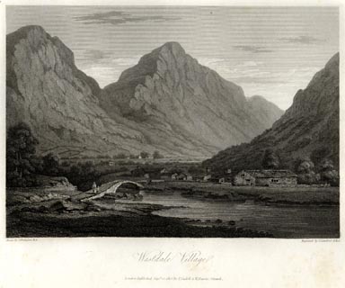 click to enlarge click to enlargeFA0418.jpg printed, bottom left, right, centre "Drawn by J. Farington R.A. / Engraved by J. Landseer A.R.A. / Wastdale Village. / London Published Septr. 15, 1815, by T. Cadell &W. Davies, Strand." Descriptive text:- "WASTDALE VILLAGE," "... the valley is closely surrounded by mountains. That which is most conspicuous in our view rises in the form of a cone, to a stupendous height, and presents a precipitous front; which, under varying effects of light and shade, exhibits alternately the aweful, the beautiful, and the sublime. ..." item:- Armitt Library : A6666.18 Image © see bottom of page |
|||||||||||||||||||||||||||||
|
|
||||||||||||||||||||||||||||||
| evidence:- | old map:- Otley 1818 placename:- Gable |
|||||||||||||||||||||||||||||
| source data:- | Map, uncoloured engraving, The District of the Lakes,
Cumberland, Westmorland, and Lancashire, scale about 4 miles to
1 inch, by Jonathan Otley, 1818, engraved by J and G Menzies,
Edinburgh, Scotland, published by Jonathan Otley, Keswick,
Cumberland, et al, 1833. OT02NY21.jpg item:- JandMN : 48.1 Image © see bottom of page |
|||||||||||||||||||||||||||||
|
|
||||||||||||||||||||||||||||||
| evidence:- | outline view:- Otley 1823 (4th edn 1830) placename:- Great Gable placename:- Gable |
|||||||||||||||||||||||||||||
| source data:- | Print, engraving, outline view, Some of the Western Mountains as seen from Helvellyn,
published by Jonathan Otley, Keswick, Cumberland et al, 1830.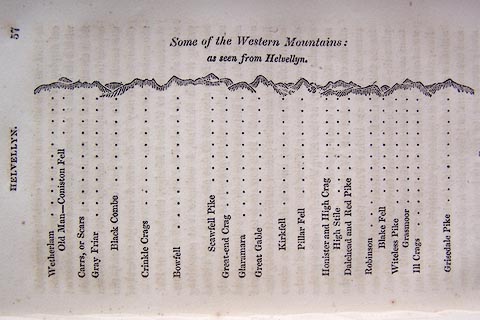 click to enlarge click to enlargeO75E02.jpg p.57 in A Concise Description of the English Lakes, by Jonathan Otley, 4th edition, 1830. "Some of the Western Mountains: / as seen from Helvellyn." "Wetherlam / Old Man - Coniston Fell / Carrs, or Scars / Gray Friar / Black Combe / Crinkle Crags / Bowfell / Scawfell Pike / Great-end Crag / Glaramara / Great Gable / Kirkfell / Pillar Fell / Honister and High Crag / High Stile / Dalehead and Red Pike / Robinson / Blake Fell / Witeless Pike / Grasmoor / Ill Crags / Grisedale Pike" item:- Armitt Library : A1175.3 Image © see bottom of page |
|||||||||||||||||||||||||||||
|
|
||||||||||||||||||||||||||||||
| evidence:- | outline view:- Otley 1823 (4th edn 1830) placename:- Great Gable placename:- Gable |
|||||||||||||||||||||||||||||
| source data:- | Print, engraving, outline view, Mountains of Coniston, Langdale, &c. as they appear
from the road between Troutbeck Bridge and Bowness, published by Jonathan Otley, Keswick,
Cumberland et al, 1830.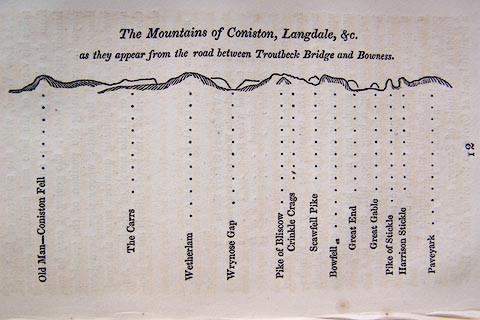 click to enlarge click to enlargeO75E04.jpg p.97 in A Concise Description of the English Lakes, by Jonathan Otley, 4th edition, 1830. "The Mountains of Coniston, Langdale, &c. / as they appear from the road between Troutbeck Bridge and Bowness." "Old Man - Coniston Fell / The Carrs / Wetherlam / Wrynose Gap / Pike of Bliscow / Crinkle Crags / Scawfell Pike / Bowfell / Great End / Great Gable / Pike of Stickle / Harrison Stickle / Paveyark" item:- Armitt Library : A1175.4 Image © see bottom of page |
|||||||||||||||||||||||||||||
|
|
||||||||||||||||||||||||||||||
| evidence:- | outline view:- Otley 1823 (4th edn 1830) placename:- Great Gable placename:- Gable |
|||||||||||||||||||||||||||||
| source data:- | Print, engraving, outline view, The Mountains of Crummock and Buttermere as seen on
the Road between Scale-Hill and Loweswater, published by Jonathan Otley, Keswick,
Cumberland et al, 1830.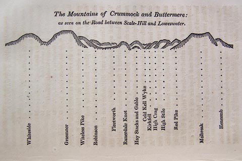 click to enlarge click to enlargeO75E07.jpg p.125 in A Concise Description of the English Lakes, by Jonathan Otley, 4th edition, 1830. "The Mountains of Crummock and Buttermere: / as seen on the Road between Scale-Hill and Loweswater." "Whiteside / Grasmoor / Witeless Pike / Robinson / Fleetworth / Rannerdale Knot / Hay Stacks and Gable / Cold Kell Wyke / Kirkfell / High Crag / High Stile / Red Pike / Melbreak / Hencomb" item:- Armitt Library : A1175.7 Image © see bottom of page |
|||||||||||||||||||||||||||||
|
|
||||||||||||||||||||||||||||||
| evidence:- | outline view:- Otley 1823 (4th edn 1830) placename:- Great Gable placename:- Gable |
|||||||||||||||||||||||||||||
| source data:- | Print, engraving, outline view, Mountains round Wastwater as seen from the Strands
in Nether Wasdale, published by Jonathan Otley, Keswick, Cumberland et al, 1830.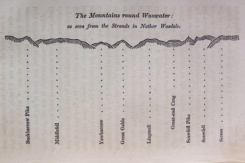 click to enlarge click to enlargeO75E08.jpg p.129 in A Concise Description of the English Lakes, by Jonathan Otley, 4th edition, 1830. "The Mountains round Wastwater: / as seen from the Strands in Nether Wasdale." "Buckbarrow Pike / Middlefell / Yewbarrow / Great Gable / Lingmell / Great-end Crag / Scawfell Pike / Scawfell / Screes" item:- Armitt Library : A1175.8 Image © see bottom of page |
|||||||||||||||||||||||||||||
|
|
||||||||||||||||||||||||||||||
| evidence:- | outline view:- Otley 1823 (4th edn 1830) placename:- Great Gable placename:- Gable |
|||||||||||||||||||||||||||||
| source data:- | Print, engraving, outline view, Mountains of Ennerdale as seen from Kirkland, published
by Jonathan Otley, Keswick, Cumberland et al, 1830.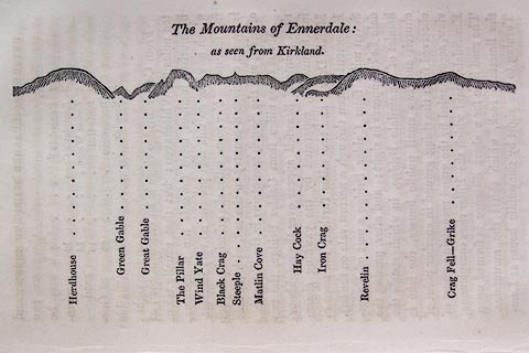 click to enlarge click to enlargeO75E09.jpg p.131 in A Concise Description of the English Lakes, by Jonathan Otley, 4th edition, 1830. "The Mountains of Ennerdale: / as seen from Kirkland." "Herdhouse / Green Gable / Great Gable / The Pillar / Wind Yate / Black Crag / Steeple / Matlin Cove / Hay Cock / Iron Crag / Revelin / Crag Fell - Grike" item:- Armitt Library : A1175.9 Image © see bottom of page |
|||||||||||||||||||||||||||||
|
|
||||||||||||||||||||||||||||||
| evidence:- | outline view:- Otley 1823 (8th edn 1849) placename:- Great Gable |
|||||||||||||||||||||||||||||
| source data:- | Engraving, outline view of mountains, Windermere looking towards the West from the
Road between Troutbeck and Bowness, drawn by T Binns, engraved by O Jewitt, opposite
p.4 of A Descriptive Guide of the English Lakes, by Jonathan Otley, 8th edition, 1849.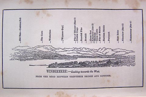 click to enlarge click to enlargeO80E03.jpg item:- Armitt Library : A1180.4 Image © see bottom of page |
|||||||||||||||||||||||||||||
|
|
||||||||||||||||||||||||||||||
| evidence:- | outline view:- Otley 1823 (8th edn 1849) placename:- Great Gavel |
|||||||||||||||||||||||||||||
| source data:- | Engraving, outline view of mountains, Crummock and Buttermere from the Road near Loweswater
Church, drawn by T Binns, engraved by O Jewitt, opposite p.18 of A Descriptive Guide
of the English Lakes, by Jonathan Otley, 8th edition, 1849.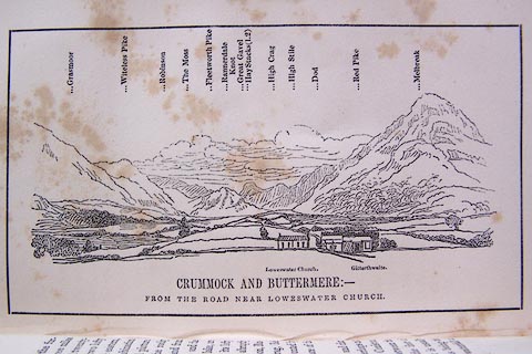 click to enlarge click to enlargeO80E10.jpg item:- Armitt Library : A1180.11 Image © see bottom of page |
|||||||||||||||||||||||||||||
|
|
||||||||||||||||||||||||||||||
| evidence:- | outline view:- Otley 1823 (8th edn 1849) placename:- Great Gable |
|||||||||||||||||||||||||||||
| source data:- | Engraving, outline view of mountains, Mountains of Wast Water as seen from Nether
Wasdale, drawn by T Binns, engraved by O Jewitt, opposite p.22 of A Descriptive Guide
of the English Lakes, by Jonathan Otley, 8th edition, 1849.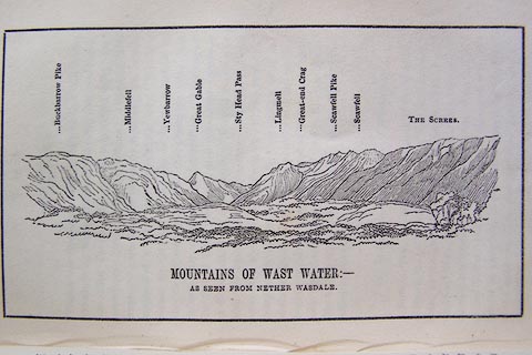 click to enlarge click to enlargeO80E13.jpg item:- Armitt Library : A1180.14 Image © see bottom of page |
|||||||||||||||||||||||||||||
|
|
||||||||||||||||||||||||||||||
| evidence:- | outline view:- Otley 1823 (8th edn 1849) placename:- Great Gable |
|||||||||||||||||||||||||||||
| source data:- | Engraving, outline view of mountains, A Group of Mountains seen from Helvellyn, looking
towards the South West, drawn by T Binns, engraved by O Jewitt, opposite p.50 of A
Descriptive Guide of the English Lakes, by Jonathan Otley, 8th edition, 1849.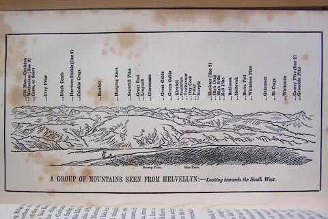 click to enlarge click to enlargeO80E17.jpg item:- Armitt Library : A1180.18 Image © see bottom of page |
|||||||||||||||||||||||||||||
|
|
||||||||||||||||||||||||||||||
| evidence:- | outline view:- Otley 1823 (5th edn 1834) |
|||||||||||||||||||||||||||||
| source data:- | Print, woodcut outline view, The Mountains of Coniston, Langdale, Etc, by Jonathan
Otley, Keswick, Cumberland, 1830.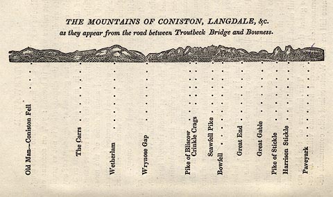 click to enlarge click to enlargeOT2E01.jpg Printed on p.7 of A Concise Description of the English Lakes, by Jonathan Otley, 5th edition, 1834. "THE MOUNTAINS OF CONISTON, LANGDALE, &c. as they appear from the road between Troutbeck Bridge and Bowness." Mountains in the view are listed:- "Old Man - Coniston Fell / The Carrs / Wetherlam / Wrynose Gap / Pike of Bliscow / Crinkle Crags / Scawfell Pike / Bowfell / Great End / Great Gable / Pike of Stickle / Harrison Stickle / Paveyark" item:- JandMN : 48.2 Image © see bottom of page |
|||||||||||||||||||||||||||||
|
|
||||||||||||||||||||||||||||||
| evidence:- | outline view:- Otley 1823 (5th edn 1834) placename:- Gable |
|||||||||||||||||||||||||||||
| source data:- | Print, woodcut outline view, The Mountains of Crummock and
Buttermere, by Jonathan Otley, Keswick, Cumberland, 1830.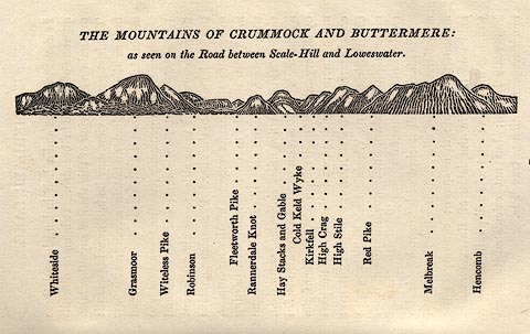 click to enlarge click to enlargeOT2E05.jpg Printed on p.25 of A Concise Description of the English Lakes, by Jonathan Otley, 5th edition, 1834. "THE MOUNTAINS OF CRUMMOCK AND BUTTERMERE: as seen on the Road between Scale-Hill and Loweswater." "Whiteside / Grasmoor / Witeless Pike / Robinson / Fleetworth Pike / Rannerdale Knot / Hay Stacks and Gable / Cold Keld Wyke / Kirkfell / High Crag / High Stile / Red Pike / Melbreak / Hencomb" item:- JandMN : 48.6 Image © see bottom of page |
|||||||||||||||||||||||||||||
|
|
||||||||||||||||||||||||||||||
| evidence:- | outline view:- Otley 1823 (5th edn 1834) |
|||||||||||||||||||||||||||||
| source data:- | Print, woodcut outline view, The Mountains of Ennerdale, by
Jonathan Otley, Keswick, Cumberland, 1830.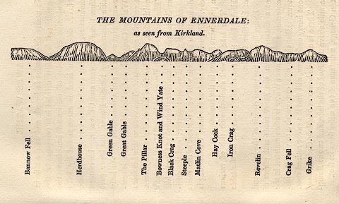 click to enlarge click to enlargeOT2E06.jpg Printed on p.27 of A Concise Description of the English Lakes, by Jonathan Otley, 5th edition, 1834. "THE MOUNTAINS OF ENNERDALE: as seen from Kirkland." "Bannow Fell / Herdhouse / Green Gable / Great Gable / The Pillar / Bowness Knot and Wind Yate / Black Crag / Steeple / Matlin Cove / Hay Cock / Iron Crag / Revelin / Crag Fell / Grike" item:- JandMN : 48.7 Image © see bottom of page |
|||||||||||||||||||||||||||||
|
|
||||||||||||||||||||||||||||||
| evidence:- | outline view:- Otley 1823 (5th edn 1834) |
|||||||||||||||||||||||||||||
| source data:- | Print, woodcut outline view, Mountains of Wast Water, by
Jonathan Otley, Keswick, Cumberland, 1830.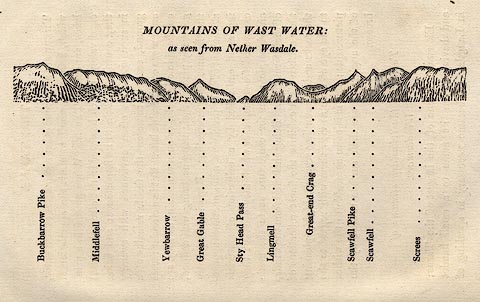 click to enlarge click to enlargeOT2E07.jpg Printed on p.31 of A Concise Description of the English Lakes, by Jonathan Otley, 5th edition, 1834. "THE MOUNTAINS OF WAST WATER: as seen from Nether Wasdale." "Buckbarrow Pike / Middlefell / Yewbarrow / Great Gable / Sty Head Pass / Lingmell / Great-end Crag / Scawfell Pike / Scawfell / Screes" item:- JandMN : 48.8 Image © see bottom of page |
|||||||||||||||||||||||||||||
|
|
||||||||||||||||||||||||||||||
| evidence:- | outline view:- Otley 1823 (5th edn 1834) |
|||||||||||||||||||||||||||||
| source data:- | Print, woodcut outline view, A Group of Mountains, seen from
Helvellyn, by Jonathan Otley, Keswick, Cumberland, 1830.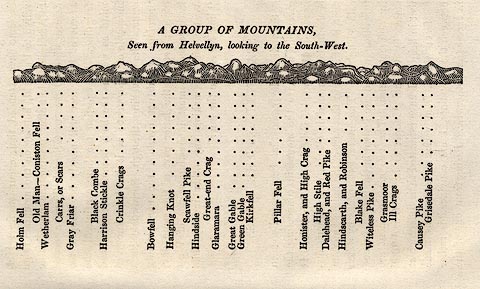 click to enlarge click to enlargeOT2E09.jpg Printed on p.63 of A Concise Description of the English Lakes, by Jonathan Otley, 5th edition, 1834. "A GROUP OF MOUNTAINS, Seen from Helvellyn, looking to the South-West." "Holm Fell / Old Man - Coniston Fell / Wetherlam / Carrs, or Scars / Gray Friar / Black Combe / Harrison Stickle / Crinkle Crags / Bowfell / Hanging Knot / Scawfell Pike / Hindside / Great-end Crag / Glaramara / Great Gable / Green Gable / Kirkfell / Pillar Fell / Honister, and High Crag / High Stile / Dalehead, and Red Pike / Hindscarth, and Robinson / Blake Fell / Witeless Pike / Grasmoor / Ill Crags / Causey Pike / Grisedale Pike" item:- JandMN : 48.10 Image © see bottom of page |
|||||||||||||||||||||||||||||
|
|
||||||||||||||||||||||||||||||
| evidence:- | descriptive text:- Otley 1823 (5th edn 1834) placename:- Gable placename:- Great Gavel item:- altitude, Great Gable; geology; garnet; well, Great Gable; horse; granite |
|||||||||||||||||||||||||||||
| source data:- | Print, woodcut outline view, The Mountains of Coniston,
Langdale, Etc, by Jonathan Otley, Keswick, Cumberland, 1830. goto source Page 70:- "GABLE, OR GREAT GAVEL" "- So called from its shape - is a fine object as viewed from Wasdale, from Ennerdale, or from Crummock Lake; it is also seen from Windermere. It is 2925 feet in height, and is remarkable for a well of pure water on the very summit. This is not a spring issuing in the common way out of the earth; but is supplied immediately from the atmosphere, in the shape of rains and dews. It is a triangular receptacle in the rock, six inches deep, and capable of holding about two gallons; and by containing water in the driest seasons, shews how slight a degree of evaporation is carried on at this altitude. The rock of Gable is a very hard, compact, dark-coloured stone, with garnets imbedded." "..." goto sourcePage 130:- "... A steep zigzag track now descends on the side of Gable [from Sty Head], down which the horses may be led; as it is neither quite safe nor agreeable to ride. Crags of the most grotesque forms overlook the road, and the side of the hill is profusely strewed with stones, in some of which garnets may be found imbedded: and in crossing the stream which issues between Gable and Kirkfell, a rock of reddish granite may be seen, where it is denudated by the waters on both sides of the road. ..." "..." goto sourcePage 156:- "... Garnets are found imbedded in some of the rocks on Castlerigg Fell and Great Gable. ..." item:- JandMN : 48.2 Image © see bottom of page |
|||||||||||||||||||||||||||||
|
|
||||||||||||||||||||||||||||||
| evidence:- | descriptive text:- Ford 1839 (3rd edn 1843) placename:- Gable placename:- Great Gable item:- altitude, Great Gable |
|||||||||||||||||||||||||||||
| source data:- | Guide book, A Description of Scenery in the Lake District, by
Rev William Ford, published by Charles Thurnam, Carlisle, by W
Edwards, 12 Ave Maria Lane, Charles Tilt, Fleet Street, William
Smith, 113 Fleet Street, London, by Currie and Bowman,
Newcastle, by Bancks and Co, Manchester, by Oliver and Boyd,
Edinburgh, and by Sinclair, Dumfries, 1839. goto source "... THE Lake district ... consists of large masses or clusters of mountains, generally terminating in one aspiring and pre-eminent point, with the intermediate valleys occupied either by lakes and their subsidiary tarns, or by winding rivers." "The chief nuclei of these clusters are, Skiddaw and Blencathra, Helvellyn, Fairfield, Coniston Old Man, Blackcomb, Scafell, Gable, Red Pike, Grasmoor, Grisdale Pike, and the Langdale Pikes. Many noble and commanding mountains rise around these, rivalling them in height and grandeur, but still" goto sourcePage iv:- "serving as large buttresses only. In the presentation of endlessly-diversified forms, these Mountains yield to none, however individually inferior they may be, owing to their being seldom seen in a detached point of view; although, on the other hand, they have thus the advantage of forming combinations at once grand and sublime, towering above each other, or rising in ridges, like the mighty billows of the ocean." goto sourcePage 178:- "ELEVATION OF THE MOUNTAINS," "ACCORDING TO DIFFERENT AUTHORITIES."
|
|||||||||||||||||||||||||||||
|
|
||||||||||||||||||||||||||||||
| evidence:- | old map:- Ford 1839 map placename:- Great Gavel |
|||||||||||||||||||||||||||||
| source data:- | Map, uncoloured engraving, Map of the Lake District of
Cumberland, Westmoreland and Lancashire, scale about 3.5 miles
to 1 inch, published by Charles Thurnam, Carlisle, and by R
Groombridge, 5 Paternoster Row, London, 3rd edn 1843. FD02NY11.jpg "Gt. Gavel" Hill hachuring. item:- JandMN : 100.1 Image © see bottom of page |
|||||||||||||||||||||||||||||
|
|
||||||||||||||||||||||||||||||
| evidence:- | old text:- Miller 1847 placename:- Great Gabel placename:- Gabel item:- rain gauge; rainfall |
|||||||||||||||||||||||||||||
| source data:- | Book, Report on the Fall of Rain in the Lake Districts of
Cumberland and Westmoreland in 1846, by John Fletcher Miller,
printed by G Irwin, Lowther Street, Whitehaven, Cumberland, 1847. goto source Page 4:- "Note. The Lake district Gauges are five inches in diameter; they are all of the same construction, and are elevated about eighteen inches above the surface. The funnel rims are of stout sheet brass, so that the apertures cannot readily lose their circular form. The Metres were all made by Bate of the Poultry, London. - The Rain is read off daily at 9 A.M." "..." goto sourcePage 8:- 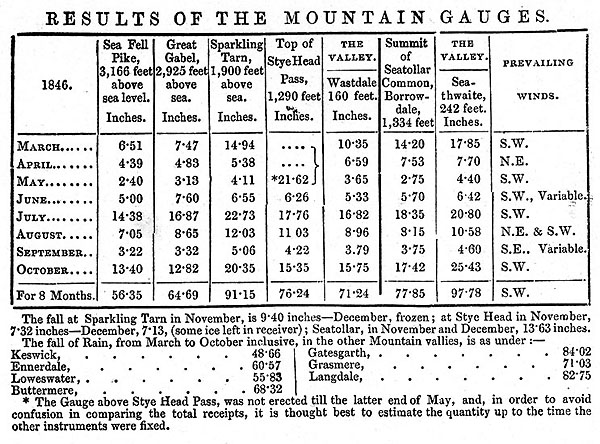 MI02Tab3.jpg goto sourcePage 9:- "REMARKS ON MOUNTAIN GAUGES." "The Mountain Gauges are on pretty much the same construction as those in the vallies, but the receivers are much more capacious, being calculated to hold nearly 80 inches of Rain." "The contents of the Gauges on Sca Fell and Gabel, have been frozen at the close of every month since October last; and as there is still no immediate prospect of our being able to measure off the water, I have concluded to publish the results obtained, without further delay: and, in the next report, I propose to give the whole monthly readings for 1846 and 1847 in one table." "..." "The Gauges on Sca Fell, Gabel, and Seatollar, are on the extreme summits of these mountains; and the whole of the instruments are freely exposed to the action of wind and rain, from almost every point of the compass." "..."
|
|||||||||||||||||||||||||||||
|
|
||||||||||||||||||||||||||||||
| evidence:- | old map:- Garnett 1850s-60s H placename:- Gable |
|||||||||||||||||||||||||||||
| source data:- | Map of the English Lakes, in Cumberland, Westmorland and
Lancashire, scale about 3.5 miles to 1 inch, published by John
Garnett, Windermere, Westmorland, 1850s-60s. GAR2NY21.jpg "Gable" hill hachuring item:- JandMN : 82.1 Image © see bottom of page |
|||||||||||||||||||||||||||||
|
|
||||||||||||||||||||||||||||||
| evidence:- | old text:- Martineau 1855 item:- altitude, Great Gable |
|||||||||||||||||||||||||||||
| source data:- | Guide book, A Complete Guide to the English Lakes, by Harriet
Martineau, published by John Garnett, Windermere, Westmorland,
and by Whittaker and Co, London, 1855; published 1855-76. goto source Page 179:- "A TABLE OF THE HEIGHTS OF MOUNTAINS IN THE COUNTIES OF CUMBERLAND, WESTMORLAND, AND LANCASHIRE." "No. : Names of Mountains. : Counties. : Height in Feet above the Sea Level." "6 : Great Gable, Wastdale : Cumberland : 2925" |
|||||||||||||||||||||||||||||
|
|
||||||||||||||||||||||||||||||
| evidence:- | old photograph:- Bell 1880s-1940s |
|||||||||||||||||||||||||||||
| source data:- | Photograph, sepia, Great Gable from beside Sprinkling Tarn, Borrowdale, Cumberland,
by Herbert Bell, photographer, Ambleside, Westmorland, 1890s. click to enlarge click to enlargeHB0881.jpg item:- Armitt Library : ALPS552 Image © see bottom of page |
|||||||||||||||||||||||||||||
|
|
||||||||||||||||||||||||||||||
| evidence:- | old photograph:- Bell 1880s-1940s |
|||||||||||||||||||||||||||||
| source data:- | Photograph, black and white, Great Gable from Kirkfell, Nether Wasdale, Cumberland,
by Herbert Bell, photographer, Ambleside, Westmorland, 1890s. click to enlarge click to enlargeHB0777.jpg internegative at lower left:- "H. Bell" stamped at reverse:- "HERBERT BELL / Photographer / AMBLESIDE" item:- Armitt Library : ALPS440 Image © see bottom of page |
|||||||||||||||||||||||||||||
|
|
||||||||||||||||||||||||||||||
| evidence:- | old photograph:- Bell 1880s-1940s |
|||||||||||||||||||||||||||||
| source data:- | Photograph, black and white, Wasdale Head and Great Gable, Nether Wasdale, Cumberland,
by Herbert Bell, photographer, Ambleside, Westmorland, 1890s. click to enlarge click to enlargeHB0774.jpg stamped at reverse:- "HERBERT BELL / Photographer / AMBLESIDE" item:- Armitt Library : ALPS437 Image © see bottom of page |
|||||||||||||||||||||||||||||
|
|
||||||||||||||||||||||||||||||
| evidence:- | old photograph:- Bell 1880s-1940s |
|||||||||||||||||||||||||||||
| source data:- | Photograph, black and white, Sprinkling Tarn and Great Gable from Esk Hause, Cumberland,
by Herbert Bell, photographer, Ambleside, Westmorland, 1890s. click to enlarge click to enlargeHB0578.jpg internegative at lower left:- "H. Bell" item:- Armitt Library : ALPS238 Image © see bottom of page |
|||||||||||||||||||||||||||||
|
|
||||||||||||||||||||||||||||||
| evidence:- | old photograph:- Bell 1880s-1940s |
|||||||||||||||||||||||||||||
| source data:- | Photograph, black and white, Great Gable from Sca Fell, Cumberland, by Herbert Bell,
photographer, Ambleside, Westmorland, 1890s. click to enlarge click to enlargeHB0579.jpg stamped on reverse:- "HERBERT BELL / Photographer / AMBLESIDE" item:- Armitt Library : ALPS239 Image © see bottom of page |
|||||||||||||||||||||||||||||
|
|
||||||||||||||||||||||||||||||
| evidence:- | old photograph:- Bell 1880s-1940s |
|||||||||||||||||||||||||||||
| source data:- | Photograph, sepia, Great Gable, Cumberland, by Herbert Bell, photographer, Ambleside,
Westmorland, 1890s. click to enlarge click to enlargeHB0580.jpg item:- Armitt Library : ALPS240 Image © see bottom of page |
|||||||||||||||||||||||||||||
|
|
||||||||||||||||||||||||||||||
| evidence:- | old photograph:- Bell 1880s-1940s item:- snow |
|||||||||||||||||||||||||||||
| source data:- | Photograph, black and white, Great Gable and Pillar from Sca Fell, Cumberland, by
Herbert Bell, photographer, Ambleside, Westmorland, 1890s. click to enlarge click to enlargeHB0577.jpg internegative at lower right:- "H. Bell" item:- Armitt Library : ALPS237 Image © see bottom of page |
|||||||||||||||||||||||||||||
|
|
||||||||||||||||||||||||||||||
| evidence:- | old print:- Heaton Cooper 1905 (edn 1908) placename:- Great Gable |
|||||||||||||||||||||||||||||
| source data:- | Print, colour halftone, Wastdalehead and Great Gable, Towards evening in autumn, Nether
Wasdale, Cumberland, from a watercolour painting by Alfred Heaton Cooper, published
by Adam and Charles Black, London, 2nd edn 1908.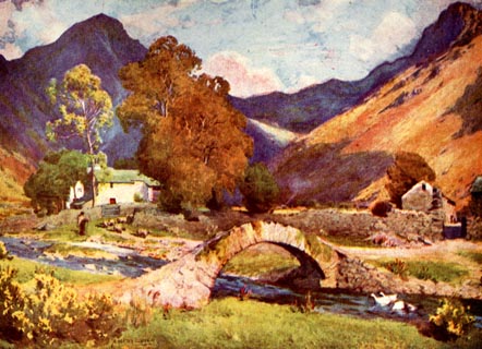 click to enlarge click to enlargeHC0132.jpg Showing the packhorse bridge, Wasdale Head. Opposite p.86 of The English Lakes, painted by Alfred Heaton Cooper, described by William T Palmer. printed at tissue opposite the print:- "WASTDALEHEAD AND GREAT GABLE / Towards evening in autumn" printed at signed lower left:- "[A HEATON COOPER]" item:- JandMN : 468.32 Image © see bottom of page |
|||||||||||||||||||||||||||||
|
|
||||||||||||||||||||||||||||||
| evidence:- | text:- Mason 1907 (edn 1930) |
|||||||||||||||||||||||||||||
| source data:- | Text book, The Ambleside Geography Books bk.III, The Counties of
England, by Charlotte M Mason, published by Kegan Paul, Trench,
Trubner and Co, Broadway House, 68-74 Carter Lane, and the
Parents' Educational Union Office, 26 Victoria Street, London,
edn 1930. MSN1P023.txt Page 23:- "..." "... to know that the Great Gable is something like the gable of a house; ..." |
|||||||||||||||||||||||||||||
|
|
||||||||||||||||||||||||||||||
| evidence:- | old map:- Postlethwaite 1877 (3rd edn 1913) placename:- Great Gable |
|||||||||||||||||||||||||||||
| source data:- | Map, uncoloured engraving, Map of the Lake District Mining Field, Westmorland, Cumberland,
Lancashire, scale about 5 miles to 1 inch, by John Postlethwaite, published by W H
Moss and Sons, 13 Lowther Street, Whitehaven, Cumberland, 1877 edn 1913.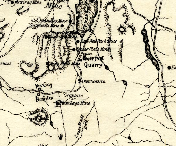 PST2NY21.jpg "Great Gable" hill hachuring item:- JandMN : 162.2 Image © see bottom of page |
|||||||||||||||||||||||||||||
|
|
||||||||||||||||||||||||||||||
| evidence:- | old postcard:- placename:- Great Gable |
|||||||||||||||||||||||||||||
| source data:- | Postcard, sepia coloured photograph, Wast Water and Great Gable, Nether Wasdale, Cumberland,
published by G P Abraham, Keswick, Cumberland, about 1936?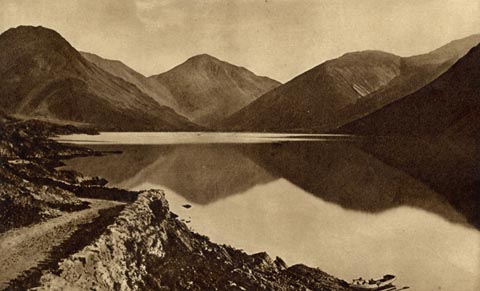 click to enlarge click to enlargePH0094.jpg printed at bottom:- "WASTWATER AND GREAT GABLE" printed at rev:- "Photogravure Series by G. P. ABRAHAM, LTD. (copyright) KESWICK" postmark:- "[ ] / OC 13 / [3]6 / [ CUMBER ]" item:- JandMN : 962 Image © see bottom of page |
|||||||||||||||||||||||||||||
|
|
||||||||||||||||||||||||||||||
| evidence:- | old print:- MacBride 1922 placename:- Great Gable |
|||||||||||||||||||||||||||||
| source data:- | Print, colour, Sprinkling Tarn and Great Gable, by Alfred Heaton Cooper, published
by Adam and Charles Black, 4-6 Soho Square, London, 2nd edn 1928.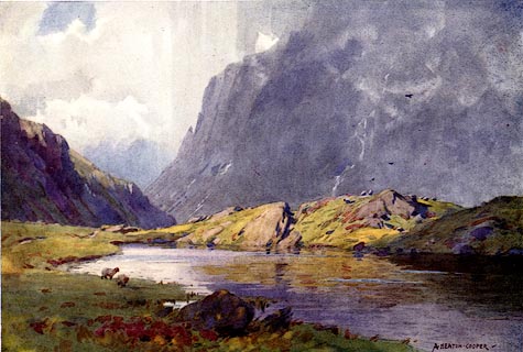 click to enlarge click to enlargeMB0104.jpg Tipped in opposite p.17 in Wild Lakeland by MacKenzie MacBride. printed at bottom:- "SPRINKLING TARN AND GREAT GABLE" signed at lower right:- "A. HEATON COOPER" item:- JandMN : 195.6 Image © see bottom of page |
|||||||||||||||||||||||||||||
|
|
||||||||||||||||||||||||||||||
| evidence:- | outline view:- LMS 1920s |
|||||||||||||||||||||||||||||
| source data:- | Hills of Lakeland in Outline, published in the LMS Route Book No.3, The Track of the
Royal Scot, by the London, Midland and Scottish Railway, LMS, 1920s.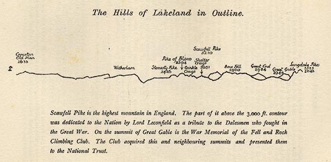 click to enlarge click to enlargeLS1E32.jpg item:- JandMN : 95.5 Image © see bottom of page |
|||||||||||||||||||||||||||||
|
|
||||||||||||||||||||||||||||||
| evidence:- | old photograph:- Bogg 1898 placename:- Great Gable item:- storm |
|||||||||||||||||||||||||||||
| source data:- | Photograph, halftone print, Storm on Great Gable, Nether Wasdale, Cumberland, by Bowen,
published by Edmund Bogg, 3 Woodhouse Lane, and James Miles, Guildford Street, Leeds,
Yorkshire, 1898.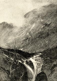 click to enlarge click to enlargeBGG178.jpg Included on p.202 of Lakeland and Ribblesdale, by Edmund Bogg. item:- JandMN : 231.78 Image © see bottom of page |
|||||||||||||||||||||||||||||
|
|
||||||||||||||||||||||||||||||
| evidence:- | old photograph:- Bogg 1898 placename:- Great Gable item:- climbing |
|||||||||||||||||||||||||||||
| source data:- | Photograph, halftone print, Wasdale Head and Great Gable, Nether Wasdale, Cumberland,
by F Leach, published by Edmund Bogg, 3 Woodhouse Lane, and James Miles, Guildford
Street, Leeds, Yorkshire, 1898.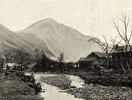 click to enlarge click to enlargeBGG157.jpg Included on p.168 of Lakeland and Ribblesdale, by Edmund Bogg. item:- JandMN : 231.57 Image © see bottom of page |
|||||||||||||||||||||||||||||
|
|
||||||||||||||||||||||||||||||
| evidence:- | outline view:- Jenkinson 1875 placename:- Great Gable |
|||||||||||||||||||||||||||||
| source data:- | Print, lithograph, outline view, Panoramic Sketches from Helvellyn, Westmorland, by
Edwin A Pettitt, London, published by Edward Stanford, 55 Charing Cross, London, 1875. click to enlarge click to enlargeJk01E1.jpg "... Great Gable ..." item:- JandMN : 28.5 Image © see bottom of page |
|||||||||||||||||||||||||||||
|
|
||||||||||||||||||||||||||||||
| evidence:- | outline view:- Jenkinson 1875 placename:- Great Gable |
|||||||||||||||||||||||||||||
| source data:- | Print, lithograph, outline view, Panoramic Sketches from Skiddaw, Cumberland, by Edwin
A Pettitt, London, published by Edward Stanford, 55 Charing Cross, London, 1875. click to enlarge click to enlargeJk01E2.jpg "... Great Gable ..." item:- JandMN : 28.8 Image © see bottom of page |
|||||||||||||||||||||||||||||
|
|
||||||||||||||||||||||||||||||
| evidence:- | outline view:- Jenkinson 1875 placename:- Great Gable |
|||||||||||||||||||||||||||||
| source data:- | Print, lithograph, outline view, Panoramic Sketches from Scawfell Pike, Cumberland,
by Edwin A Pettitt, London, published by Edward Stanford, 55 Charing Cross, London,
1875. click to enlarge click to enlargeJk01E3.jpg "... Great Gable ..." item:- JandMN : 28.9 Image © see bottom of page |
|||||||||||||||||||||||||||||
|
|
||||||||||||||||||||||||||||||
| evidence:- | outline view:- Matthew 1866 placename:- Great Gable |
|||||||||||||||||||||||||||||
| source data:- | Print, engraving, outline view, Mountains as seen from the Road to Wastwater near
Murthwaiteside, Cumberland, published by J Richardson, Highgate, Kendal, Westmorland,
1866.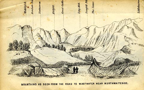 click to enlarge click to enlargeMW1E03.jpg Tipped in before p.1 of The English Lakes, Peaks and Passes, from Kendal to Keswick, by George King Matthew. printed at bottom:- "MOUNTAINS AS SEEN FROM THE ROAD TO WASTWATER NEAR MURTHWAITESIDE." printed at caption to mountains:- "... Great Gable. ..." item:- Armitt Library : A1168.3 Image © see bottom of page |
|||||||||||||||||||||||||||||
|
|
||||||||||||||||||||||||||||||
| evidence:- | outline view:- Black 1856 (23rd edn 1900) placename:- Great Gable |
|||||||||||||||||||||||||||||
| source data:- | Print, lithograph, Outline Views, Windermere - Mountains as seen from the North End
of Belle Isle, Windermere, and Mountains as seen from Biscay How, Bowness, by J Flintoft,
Keswick, Cumberland, engraved by R Mason, Edinburgh, Lothian, about 1900.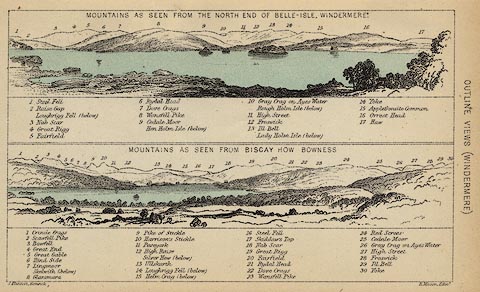 click to enlarge click to enlargeBC08E1.jpg "... 5 Great Gable ..." item:- JandMN : 37.4 Image © see bottom of page |
|||||||||||||||||||||||||||||
|
|
||||||||||||||||||||||||||||||
| evidence:- | outline view:- Black 1856 (23rd edn 1900) placename:- Great Gable |
|||||||||||||||||||||||||||||
| source data:- | Print, lithograph, Outline Views, Buttermere - Mountains as seen from the Knots near
the Hotel at Buttermere, and Mountains as seen at the Seat in Lanthwaite Wood, Scale
Hill, by J Flintoft, Keswick, Cumberland, engraved by R Mason, Edinburgh, Lothian,
about 1900. click to enlarge click to enlargeBC08E5.jpg "... 5 Great Gable ... 5 Great Gable ..." item:- JandMN : 37.19 Image © see bottom of page |
|||||||||||||||||||||||||||||
|
|
||||||||||||||||||||||||||||||
| evidence:- | outline view:- Black 1856 (23rd edn 1900) placename:- Great Gable |
|||||||||||||||||||||||||||||
| source data:- | Print, lithograph, Outline Views, Haws and Wastwater - Mountains as seen from Burn-Banks
near the Foot of Hawes Water, and Mountains as seen near Nether Wastdale at the First
Bridge on the road to Wast-Water, by J Flintoft, Keswick, Cumberland, engraved by
R Mason, Edinburgh, Lothian, about 1900.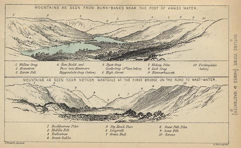 click to enlarge click to enlargeBC08E6.jpg "... 4 Great Gable ..." item:- JandMN : 37.21 Image © see bottom of page |
|||||||||||||||||||||||||||||
|
|
||||||||||||||||||||||||||||||
| evidence:- | outline view:- Martineau 1855 placename:- Great Gable |
|||||||||||||||||||||||||||||
| source data:- | Print, engraving, outline view, Mountains seen from Lanthwaite Wood Crummock Water,
drawn by L Aspland, engraved by W Banks, Edinburgh, published by John Garnett, Windermere,
Westmorland, and by Whittaker and Co, London, 1855.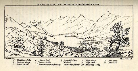 click to enlarge click to enlargeMNU113.jpg Opposite p.84 in A Complete Guide to the English Lakes, by Harriet Martineau. The view is captioned, numbers refering to mountains in the image - 1 Whiteless Pike, 2 Honister Crag, 3 Green Gable, 4 Great End, 5 Great Gable / Rannerdale Knott (beneath), 6 Scawfell Pike, 7 Kirkfell / Scarf Gap (below), 8 High Crag, 9 High Stile, 10 Bleaberry Crag, 11 Red Pike, 12 Melbreak. printed at top:- "MOUNTAINS SEEN FROM LANTHWAITE WOOD CRUMMOCK WATER." printed at bottom left, right:- "L Aspland Delt. / W Banks Sc Edinr." item:- Armitt Library : A1159.13 Image © see bottom of page |
|||||||||||||||||||||||||||||
|
|
||||||||||||||||||||||||||||||
| evidence:- | outline view:- Linton 1852 placename:- Great Gable |
|||||||||||||||||||||||||||||
| source data:- | Print, engraving, outline views, Mountains as Seen from the Esk Viaduct, the Eskmeals
Viaduct, and Mountains as Seen from the Viaduct near Drigg, the Irt Viaduct, Whitehaven
and Furness Junction Railway, Cumberland, engraved by W H Lizars, Edinburgh, published
by Whittaker and Co, London, and by R Gibson and Son and by Callander and Dixon, Whitehaven,
Cumberland, 1852.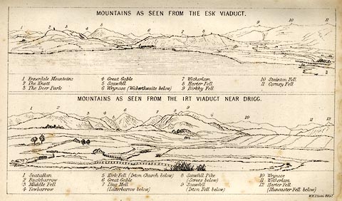 click to enlarge click to enlargeLN1E13.jpg Tipped in opposite p.86 of A Handbook of the Whitehaven and Furness Railway, by John Linton. item:- Armitt Library : A1158.11 Image © see bottom of page |
|||||||||||||||||||||||||||||
|
|
||||||||||||||||||||||||||||||
| evidence:- | outline view:- Black 1841 (3rd edn 1846) placename:- Great Gable |
|||||||||||||||||||||||||||||
| source data:- | Print, engraving, outline view, Mountains as seen from the North End of Belle Isle,
Windermere, and Mountains as seen from Bisket How, Bowness, by J Flintoft, Keswick,
Cumberland, engraved by R Mason, Edinburgh, about 1844.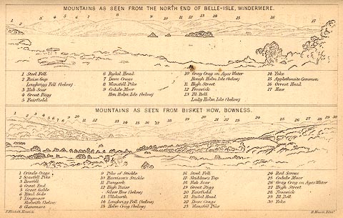 click to enlarge click to enlargeBC02E1.jpg "... 5 Great Gable ..." item:- JandMN : 32.3 Image © see bottom of page |
|||||||||||||||||||||||||||||
|
|
||||||||||||||||||||||||||||||
| evidence:- | outline view:- Black 1841 (3rd edn 1846) placename:- Great Gable |
|||||||||||||||||||||||||||||
| source data:- | Print, engraving, outline view, Mountains as seen from The Knots near the Victoria
at Buttermere, and Mountains as seen at the Seat in Lanthwaite Wood, Scale Hill, by
J Flintoft, Keswick, Cumberland, engraved by R Mason, Edinburgh, Lothian, about 1846.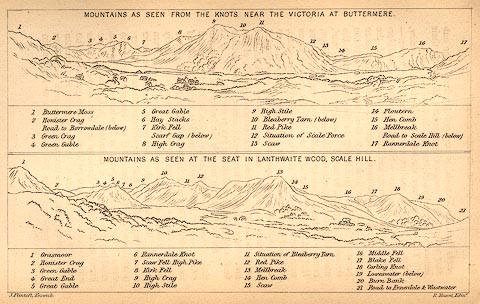 click to enlarge click to enlargeBC02E7.jpg "... 5 Great Gable ... 5 Great Gable ..." item:- JandMN : 32.11 Image © see bottom of page |
|||||||||||||||||||||||||||||
|
|
||||||||||||||||||||||||||||||
| evidence:- | outline view:- Black 1841 (3rd edn 1846) placename:- Great Gable |
|||||||||||||||||||||||||||||
| source data:- | Print, engraving, outline view, Mountains as seen from Burn Banks near the Foot of
Hawes Water, and Mountains as seen near Strands in Wastdale at the First bridge on
the Road to Wast Water, by J Flintoft, Keswick, Cumberland, engraved by R Mason, Edinburgh,
Lothian, about 1846.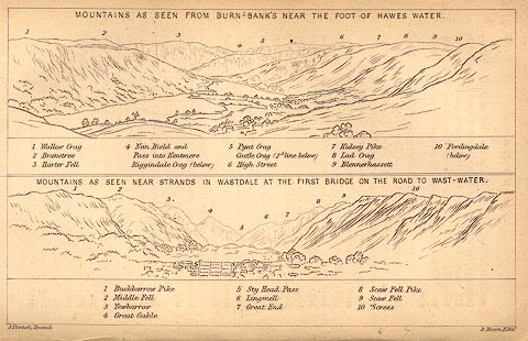 click to enlarge click to enlargeBC02E8.jpg "... 4 Great Gable ..." item:- JandMN : 32.12 Image © see bottom of page |
|||||||||||||||||||||||||||||
|
|
||||||||||||||||||||||||||||||
| evidence:- | outline view:- placename:- Great Gavel |
|||||||||||||||||||||||||||||
| source data:- | Print, hand coloured engraving, Wast Water and Scawfell Pikes from the Road to Calder
Bridge, Cumberland, published by Sherwood and Co, London, 1836?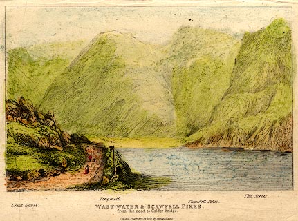 click to enlarge click to enlargePR0373.jpg Objects in the view are identified by a caption at the bottom - Great Gavel, Lingmell, Scawfell Pikes, The Screes. printed at bottom:- "WAST-WATER & SCAWFELL PIKES. / from the road to Calder Bridge. / London. Pubd. April 15th 1836 by Sherwood &Co." item:- Dove Cottage : 2008.107.373 Image © see bottom of page |
|||||||||||||||||||||||||||||
|
|
||||||||||||||||||||||||||||||
| evidence:- | old print:- |
|||||||||||||||||||||||||||||
| source data:- | Print, uncoloured engraving, Head of Wastwater, drawn by IW, engraved by R Scott,
about 1800?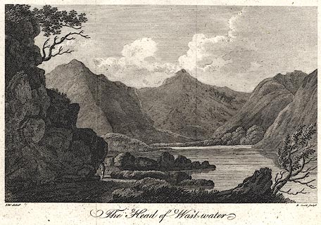 click to enlarge click to enlargePR0400.jpg printed at bottom left, right, centre:- "I.W. delint. / R. Scott sculpt. / The Head of Wastwater" item:- Dove Cottage : 2008.107.393 Image © see bottom of page |
|||||||||||||||||||||||||||||
|
|
||||||||||||||||||||||||||||||
 CAZ05.jpg and Green Gable behind. (taken 23.6.2014) 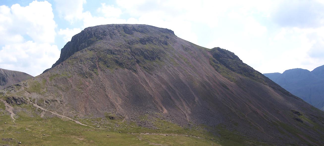 Click to enlarge BUX34.jpg (taken 4.7.2011) 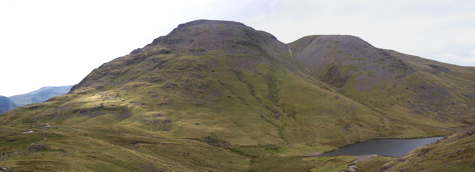 Click to enlarge BRM72.jpg (taken 14.9.2009) 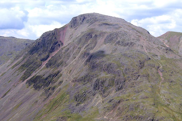 BPF46.jpg (taken 20.5.2008) 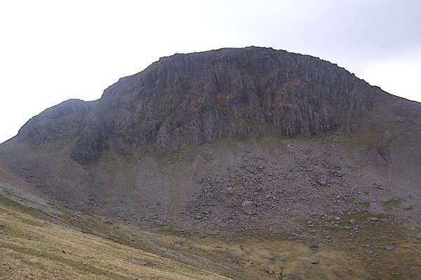 BSU17.jpg (taken 17.5.2010) 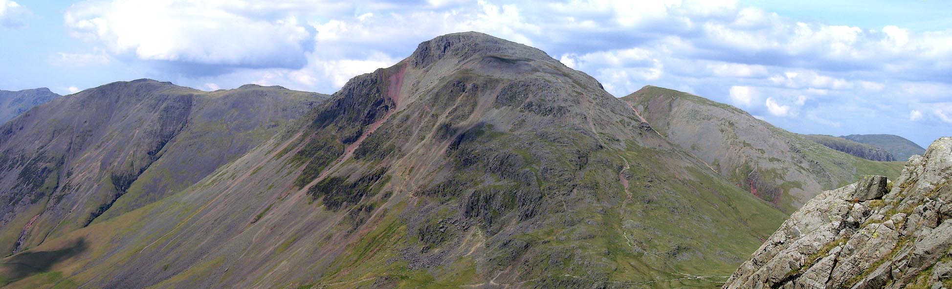 Click to enlarge BPF47.jpg (taken 20.5.2008) 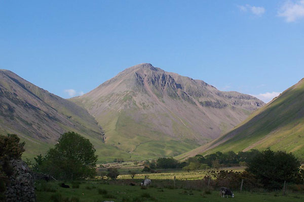 BUR32.jpg (taken 3.6.2011) 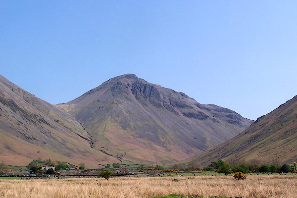 BMB43.jpg (taken 11.5.2006) 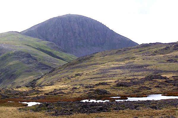 BMR53.jpg From east summit of Grey Knotts. (taken 22.9.2006) 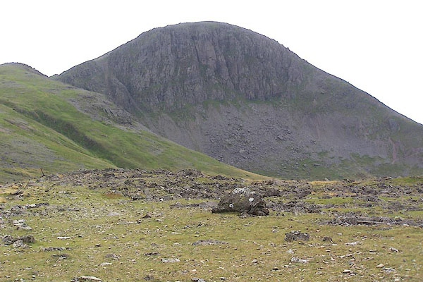 BMR61.jpg From about Brandreth. (taken 22.9.2006) 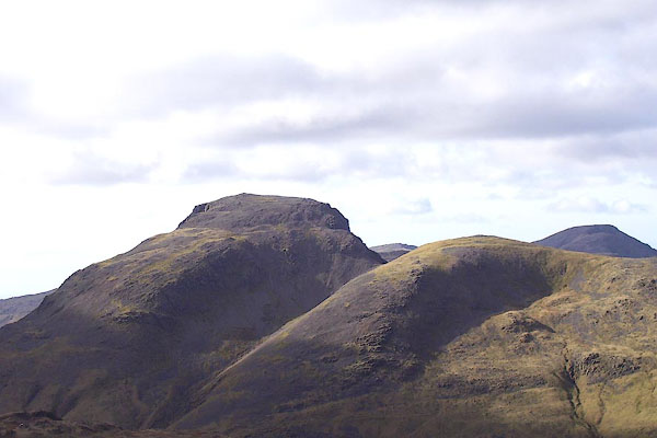 BNG80.jpg Great Gable and Green Gable infront. (taken 26.2.2007) 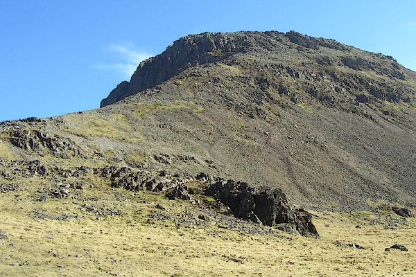 BNM78.jpg (taken 4.4.2007) 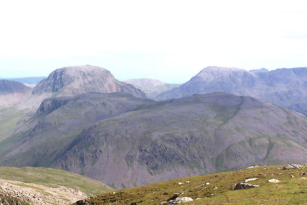 BQX37.jpg Great Gable and Kirk Fell, from Pillar. (taken 25.6.2009)  Click to enlarge BOV28.jpg Outline view from Stybarrow Dodd; Bowfell, Esk Pike, Scafell, Lingmell, Great Gable. (taken 17.3.2008) 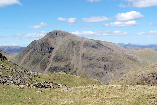 BQO22.jpg (taken 12.5.2009) 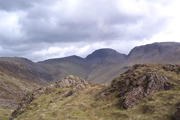 BWO31.jpg From Ennerdale. (taken 16.5.2012) 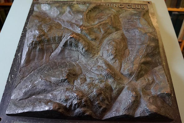 CDN35.jpg Relief map on the war memorial. (taken 9.7.2015) |
||||||||||||||||||||||||||||||
|
|
||||||||||||||||||||||||||||||
Lakes Guides menu.