 Old Cumbria Gazetteer
 |
 |
|
| Gillalees Beacon, Askerton | ||
| Gillalees Beacon | ||
| civil parish:- | Askerton (formerly Cumberland) | |
| county:- | Cumbria | |
| locality type:- | hill | |
| locality type:- | beacon (site) | |
| coordinates:- | NY57307184 (etc) | |
| 1Km square:- | NY5771 | |
| 10Km square:- | NY57 | |
| altitude:- | 1017 feet | |
| altitude:- | 310m | |
| SummaryText:- | Mapping does not make it clear what is Beacon as a hill area, and what is Beacon as a hill top; see also The Beacon | |
|
|
||
| evidence:- | old map:- OS County Series (Cmd 8 15) placename:- Gillalees Beacon |
|
| source data:- | Maps, County Series maps of Great Britain, scales 6 and 25
inches to 1 mile, published by the Ordnance Survey, Southampton,
Hampshire, from about 1863 to 1948. "Gillalees Beacon" |
|
|
|
||
| evidence:- | old map:- Donald 1774 (Cmd) placename:- Beacon |
|
| source data:- | Map, hand coloured engraving, 3x2 sheets, The County of Cumberland, scale about 1
inch to 1 mile, by Thomas Donald, engraved and published by Joseph Hodskinson, 29
Arundel Street, Strand, London, 1774.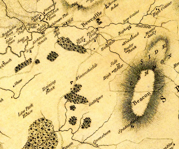 D4NY57SE.jpg "Beacon" hill hachuring; a hill or mountain item:- Carlisle Library : Map 2 Image © Carlisle Library |
|
|
|
||
| hearsay:- |
Six of the old counties can be seen from the beacon; Cumberland, Westmorland, Northumberland,
Durham, Roxburghshire, and Dumfriesshire. |
|
|
|
||
| notes:- |
supposed site of a bastle or tower |
|
| Perriam, D R &Robinson, J: 1998: Medieval Fortified Buildings of Cumbria: CWAAS::
ISBN 1 873124 23 6 |
||
|
|
||
 Lakes Guides menu.