 Old Cumbria Gazetteer
 |
 |
|
| Garnett Bridge, Garnett Bridge | ||
| Garnett Bridge | ||
| site name:- | Sprint, River | |
| locality:- | Garnett Bridge | |
| civil parish:- | Whitwell and Selside (formerly Westmorland) | |
| civil parish:- | Strickland Roger (formerly Westmorland) | |
| county:- | Cumbria | |
| locality type:- | bridge | |
| coordinates:- | SD52369926 | |
| 1Km square:- | SD5299 | |
| 10Km square:- | SD59 | |
|
|
||
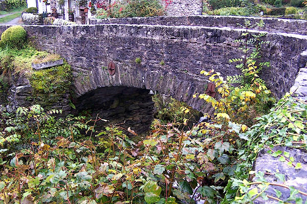 BJX23.jpg (taken 7.10.2005) 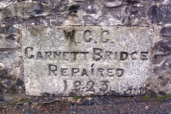 BJX24.jpg "W.C.C. GARNETT BRIDGE REPAIRED 1923" (taken 7.10.2005) |
||
|
|
||
| evidence:- | probably old map:- Saxton 1579 |
|
| source data:- | Map, hand coloured engraving, Westmorlandiae et Cumberlandiae Comitatus ie Westmorland
and Cumberland, scale about 5 miles to 1 inch, by Christopher Saxton, London, engraved
by Augustinus Ryther, 1576, published 1579-1645. Sax9NY40.jpg Low down the valley. item:- private collection : 2 Image © see bottom of page |
|
|
|
||
| evidence:- | probably old map:- Speed 1611 (Wmd) |
|
| source data:- | Map, hand coloured engraving, The Countie Westmorland and
Kendale the Cheif Towne, scale about 2.5 miles to 1 inch, by
John Speed, 1610, published by George Humble, Popes Head Alley,
London, 1611-12.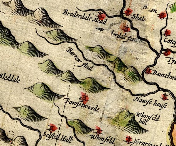 SP14NY50.jpg double line across the Sprint, bridge item:- Armitt Library : 2008.14.5 Image © see bottom of page |
|
|
|
||
| evidence:- | perhaps old map:- Sanson 1679 |
|
| source data:- | Map, hand coloured engraving, Ancien Royaume de Northumberland
aujourdhuy Provinces de Nort, ie the Ancient Kingdom of
Northumberland or the Northern Provinces, scale about 9.5 miles
to 1 inch, by Nicholas Sanson, Paris, France, 1679. click to enlarge click to enlargeSAN2Cm.jpg double line over a stream; bridge item:- Dove Cottage : 2007.38.15 Image © see bottom of page |
|
|
|
||
| evidence:- | old map:- Jefferys 1770 (Wmd) placename:- Garnet Bridge |
|
| source data:- | Map, 4 sheets, The County of Westmoreland, scale 1 inch to 1
mile, surveyed 1768, and engraved and published by Thomas
Jefferys, London, 1770.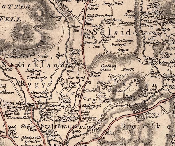 J5SD59NW.jpg "Garnet B." double line, road, across a stream; bridge item:- National Library of Scotland : EME.s.47 Image © National Library of Scotland |
|
|
|
||
| evidence:- | old map:- Cary 1789 (edn 1805) placename:- Garnet Bridge |
|
| source data:- | Map, uncoloured engraving, Westmoreland, scale about 2.5 miles
to 1 inch, by John Cary, London, 1789; edition 1805.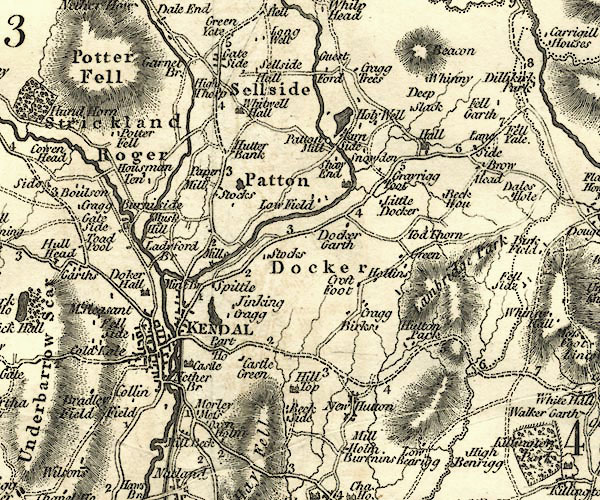 CY24SD59.jpg "Garnet Br." no buildings, but no bridge the Sprint crosses the road item:- JandMN : 129 Image © see bottom of page |
|
|
|
||
| evidence:- | old map:- Garnett 1850s-60s H placename:- Garnett Bridge |
|
| source data:- | Map of the English Lakes, in Cumberland, Westmorland and
Lancashire, scale about 3.5 miles to 1 inch, published by John
Garnett, Windermere, Westmorland, 1850s-60s. GAR2NY50.jpg "Garnett Br." road crosses stream item:- JandMN : 82.1 Image © see bottom of page |
|
|
|
||
| evidence:- | database:- Listed Buildings 2010 placename:- Garnett Bridge |
|
| source data:- | courtesy of English Heritage "GARNETT BRIDGE OVER THE RIVER SPRINT / / GARNETT BRIDGE / STRICKLAND ROGER / SOUTH LAKELAND / CUMBRIA / II / 76429 / SD5236699260" |
|
| source data:- | courtesy of English Heritage "GARNETT BRIDGE (THAT PART IN WHITEWELL AND SELSIDE C.P.) / / GARNETT BRIDGE / WHITWELL AND SELSIDE / SOUTH LAKELAND / CUMBRIA / II / 75770 / SD5236799261" |
|
| source data:- | courtesy of English Heritage "Bridge C18. Limestone rubble. Single arch carrying single track road over miniature natural gorge in limestone." |
|
| source data:- | courtesy of English Heritage "Bridge over river Sprint. Probably C18, repaired 1923. Stone rubble with dressed coping. Segmental arch with thin voussoirs. Plain parapets, that to north has plaque to south side recording repair. Roadway is approx 3.5m wide. Part listed under Strickland Roger C.P." |
|
|
|
||
| observation:- |
One inch of rain in a day, assuming it falls all over the valley, produces 4.261 x
10000 million cubic inches of water, that is 184 million gallons, which all has to
get out in the River Sprint under Garnett Bridge. |
|
|
|
||
 Lakes Guides menu.