 Old Cumbria Gazetteer
 |
 |
|
| Force Crag Mine, Above Derwent | ||
| Force Crag Mine | ||
| site name:- | Coledale Valley | |
| civil parish:- | Above Derwent (formerly Cumberland) | |
| county:- | Cumbria | |
| locality type:- | mine | |
| locality type:- | lead mine | |
| locality type:- | zinc mine | |
| locality type:- | barytes mine | |
| locality type:- | iron mine (?) | |
| locality type:- | museum | |
| coordinates:- | NY19972162 | |
| 1Km square:- | NY1921 | |
| 10Km square:- | NY12 | |
| references:- | Adams, John: 1988: Mines of the Lake District Fells: Dalesman Books (Lancaster, Lancashire)::
ISBN 0 85206 931 6 |
|
|
|
||
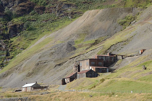
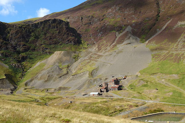 CDZ01.jpg (taken 16.9.2015) 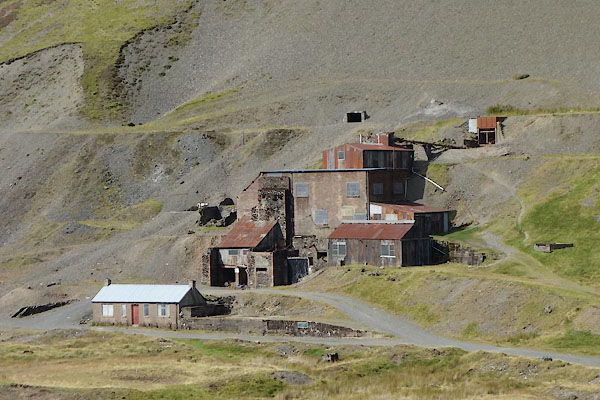 CDZ03.jpg (taken 16.9.2015) |
||
|
|
||
| evidence:- | old map:- OS County Series (Cmd 63 11) placename:- Forcecrag Mines |
|
| source data:- | Maps, County Series maps of Great Britain, scales 6 and 25
inches to 1 mile, published by the Ordnance Survey, Southampton,
Hampshire, from about 1863 to 1948. "Forcecrag Mines (Iron) / Level / Tramway" |
|
|
|
||
| evidence:- | old text:- Postlethwaite 1877 (3rd edn 1913) placename:- Force Crag Mine item:- psilomelane; barytes; blende; iron pyrites; galena; cerussite; stolzite; silver; lead ore; barium ore |
|
| source data:- | Book, Mines and Mining in the English Lake District, by John Postlethwaite, Keswick,
published by W H Moss and Sons, Whitehaven, Cumberland now Cumbria, 1877; published
1877-1913. goto source goto sourcepage 103:- "FORCE CRAG MINE." "This mine is situated at the head of Cowdale Valley, about two-and-a-half miles from Braithwaite. The bearing of the vein is nearly due east and west; and the minerals which it produces are psilomelane, sulphate barytes, blende, iron pyrites, galena, cerussite, and stolzite, or tungstate of lead. This is the only mine in which stolzite has ever been found. The galena contains about 35 ounces of silver per ton." "The deposits of sulphate barytes which occur in the Force Crag vein are amongst the most remarkable mineral deposits that have ever been found in the Skiddaw Slates; they commonly measure from three to five feet in thickness, and one was found in 1872 which measured ten feet in thickness. Some of the barytes is very" goto sourcepage 105:- "pure and white; but a great deal of it is coloured by the psilomelane with which it is associated, and with iron." "The psilomelane also occurs in considerable quantities, but very little of it can be obtained in a pure state." "The mine was opened, or probably re-opened, by Mr. Walton, of Alston, and Messrs. Dowthwaite &Cowper, of Keswick, and others, about eighty years ago; there is no definite information on this point, but the author can remember that in the year 1846 some of the proprietors had become tired of their enterprise and the mine was stopped three months in order that the Company might be wound up, and a fresh lease taken out in the names of those who were prepared to carry on the work, which they did for about thirty years, and succeeded in raising a large quantity of very valuable ore. Three levels were driven along the vein, 15 and 24 fathoms apart, near the base of the mountain (Grisdale Pike), and a great deal of ground excavated, especially in the extensive old stope, where the most productive part of the orey ground lay. A considerable quantity of ore has also been raised at three other points above the lowest level." "Messrs. Walton &Co. paid very little attention to the barytes, as it was scarcely saleable during the greater part of their tenure; but in later years it has been more extensively used in the manufacture of plate glass, and for the more questionable purpose of adulterating white lead, consequently the mineral has been in greater demand." "After a short interval of inactivity the mine was taken up again by a Company of local gentlemen, for the purpose of raising barytes. They commenced operations in the low level, but afterwards discovered that the mineral was much more plentiful higher up the mountain; therefore the old mine was abandoned, and two more levels were driven still higher up the mountain, and large deposits of barytes discovered." "A mill was erected at the mine, and another rented in the village of Braithwaite, for the purpose of grinding the mineral, and an apparatus for bleaching it was constructed at the mine; but these works were not remunerative, and the mine was abandoned in 1880." "In 1906 the mine was again taken up by Messrs. Meakin, Dennison and J. F. Lobb, who cleared and put into workable condition the three lowest levels, Nos.1, 2 and 3, erected a good modern crushing and dressing plant, propelled by a Pelton Wheel, but it proved to be unequal to the task allotted to it, the presence of so much barytes, dolomite and manganese associated with the blende, rendered almost impracticable, with the machinery and appliances in use, the production of pure marketable ore." |
|
|
|
||
| evidence:- | old map:- Postlethwaite 1877 (3rd edn 1913) placename:- Force Crag Mine |
|
| source data:- | Map, uncoloured engraving, Map of the Lake District Mining Field, Westmorland, Cumberland,
Lancashire, scale about 5 miles to 1 inch, by John Postlethwaite, published by W H
Moss and Sons, 13 Lowther Street, Whitehaven, Cumberland, 1877 edn 1913.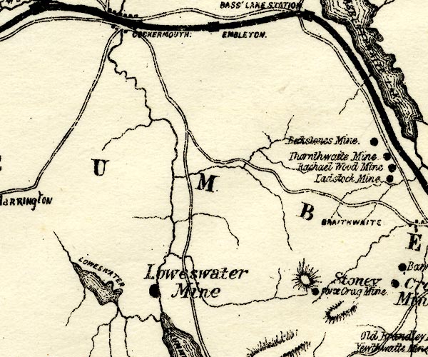 PST2NY12.jpg "Force Crag Mine" mine symbol item:- JandMN : 162.2 Image © see bottom of page |
|
|
|
||
| evidence:- | mine plan:- Postlethwaite 1877 placename:- Force Crag Mine |
|
| source data:- | Print, drawing, mine section, Section of Force Crag Mine, Above Derwent, Cumberland,
scale about 1 to 1400, published by W H Moss and Sons, 13 Lowther Street, Whitehaven,
Cumberland, 1877 edn 1913.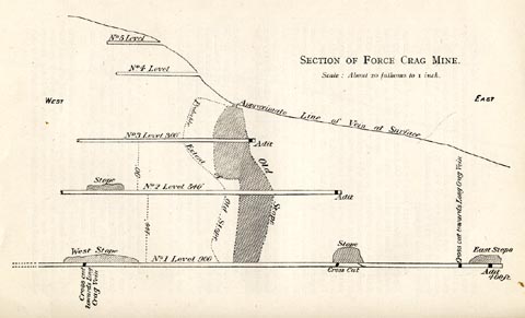 click to enlarge click to enlargePST323.jpg On p.104 of Mines and Mining in the English Lake District, by John Postlethwaite. printed, upper right "SECTION OF FORCE CRAG MINE. / Scale: About 20 fathoms to 1 inch." item:- JandMN : 162.25 Image © see bottom of page |
|
|
|
||
| evidence:- | old text:- Postlethwaite 1877 (3rd edn 1913) placename:- Force Crag Mine item:- psilomelane; barytes; blende; iron pyrites; galena; cerussite; stolzite; silver; lead ore; barium ore |
|
| source data:- | Book, Mines and Mining in the English Lake District, by John Postlethwaite, Keswick,
published by W H Moss and Sons, Whitehaven, Cumberland now Cumbria, 1877; published
1877-1913. goto source page 103:- "FORCE CRAG MINE." "This mine is situated at the head of Cowdale Valley, about two-and-a-half miles from Braithwaite. The bearing of the vein is nearly due east and west; and the minerals which it produces are psilomelane, sulphate barytes, blende, iron pyrites, galena, cerussite, and stolzite, or tungstate of lead. This is the only mine in which stolzite has ever been found. The galena contains about 35 ounces of silver per ton." "The deposits of sulphate barytes which occur in the Force Crag vein are amongst the most remarkable mineral deposits that have ever been found in the Skiddaw Slates; they commonly measure from three to five feet in thickness, and one was found in 1872 which measured ten feet in thickness. Some of the barytes is very" goto sourcepage 105:- "pure and white; but a great deal of it is coloured by the psilomelane with which it is associated, and with iron." "The psilomelane also occurs in considerable quantities, but very little of it can be obtained in a pure state." "The mine was opened, or probably re-opened, by Mr. Walton, of Alston, and Messrs. Dowthwaite &Cowper, of Keswick, and others, about eighty years ago; there is no definite information on this point, but the author can remember that in the year 1846 some of the proprietors had become tired of their enterprise and the mine was stopped three months in order that the Company might be wound up, and a fresh lease taken out in the names of those who were prepared to carry on the work, which they did for about thirty years, and succeeded in raising a large quantity of very valuable ore. Three levels were driven along the vein, 15 and 24 fathoms apart, near the base of the mountain (Grisdale Pike), and a great deal of ground excavated, especially in the extensive old stope, where the most productive part of the orey ground lay. A considerable quantity of ore has also been raised at three other points above the lowest level." "Messrs. Walton &Co. paid very little attention to the barytes, as it was scarcely saleable during the greater part of their tenure; but in later years it has been more extensively used in the manufacture of plate glass, and for the more questionable purpose of adulterating white lead, consequently the mineral has been in greater demand." "After a short interval of inactivity the mine was taken up again by a Company of local gentlemen, for the purpose of raising barytes. They commenced operations in the low level, but afterwards discovered that the mineral was much more plentiful higher up the mountain; therefore the old mine was abandoned, and two more levels were driven still higher up the mountain, and large deposits of barytes discovered." "A mill was erected at the mine, and another rented in the village of Braithwaite, for the purpose of grinding the mineral, and an apparatus for bleaching it was constructed at the mine; but these works were not remunerative, and the mine was abandoned in 1880." "In 1906 the mine was again taken up by Messrs. Meakin, Dennison and J. F. Lobb, who cleared and put into workable condition the three lowest levels, Nos.1, 2 and 3, erected a good modern crushing and dressing plant, propelled by a Pelton Wheel, but it proved to be unequal to the task allotted to it, the presence of so much barytes, dolomite and manganese associated with the blende, rendered almost impracticable, with the machinery and appliances in use, the production of pure marketable ore." |
|
|
|
||
| evidence:- | old map:- Postlethwaite 1877 (3rd edn 1913) placename:- Force Crag Mine |
|
| source data:- | Map, uncoloured engraving, Map of the Lake District Mining Field, Westmorland, Cumberland,
Lancashire, scale about 5 miles to 1 inch, by John Postlethwaite, published by W H
Moss and Sons, 13 Lowther Street, Whitehaven, Cumberland, 1877 edn 1913. PST2NY12.jpg "Force Crag Mine" mine symbol item:- JandMN : 162.2 Image © see bottom of page |
|
|
|
||
| evidence:- | mine plan:- Postlethwaite 1877 placename:- Force Crag Mine |
|
| source data:- | Print, drawing, mine section, Section of Force Crag Mine, Above Derwent, Cumberland,
scale about 1 to 1400, published by W H Moss and Sons, 13 Lowther Street, Whitehaven,
Cumberland, 1877 edn 1913. click to enlarge PST323.jpg On p.104 of Mines and Mining in the English Lake District, by John Postlethwaite. printed, upper right "SECTION OF FORCE CRAG MINE. / Scale: About 20 fathoms to 1 inch." item:- JandMN : 162.25 Image © see bottom of page |
|
|
|
||
| evidence:- | mine drawing:- KDMRS 1979-82 placename:- Force Crag Mine |
|
| source data:- | Geological Outing of the Kendal and District Mine Research Society to Force Crag Mine,
Above Derwent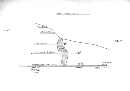 click to enlarge click to enlargeKMR18.jpg "FORCE CRAG MINE" item:- private collection : 82 Image © see bottom of page |
|
|
|
||
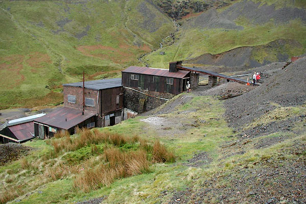
 CDZ02.jpg (taken 16.9.2015) 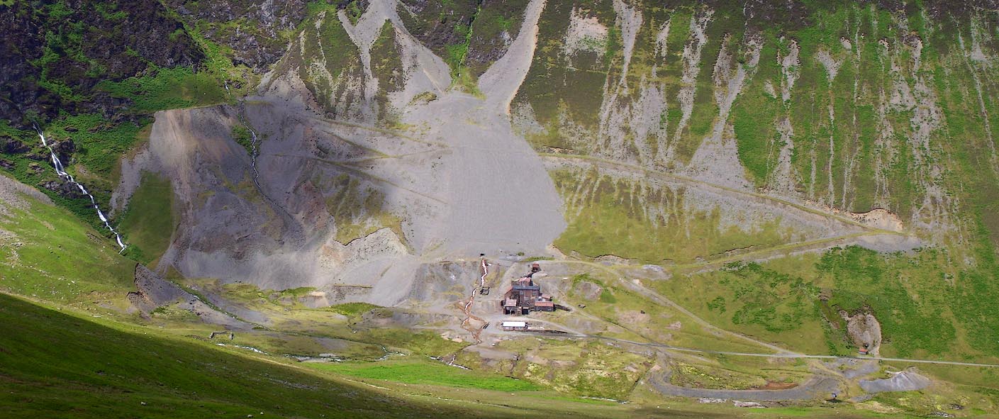 Click to enlarge BPJ42.jpg (taken 23.6.2008) 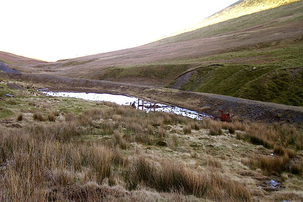 BOR85.jpg (taken 13.2.2008) 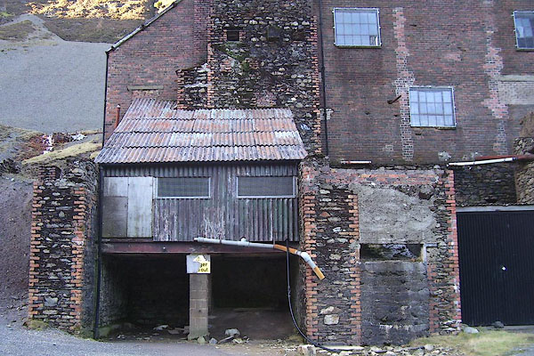 BOR91.jpg (taken 13.2.2008) 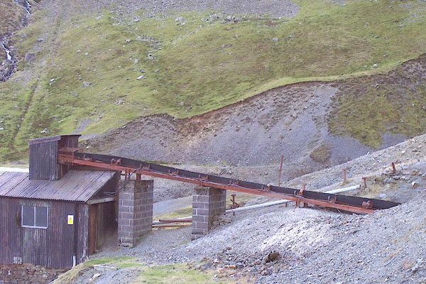 BOR86.jpg (taken 13.2.2008) 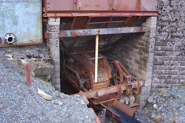 BOR87.jpg (taken 13.2.2008) 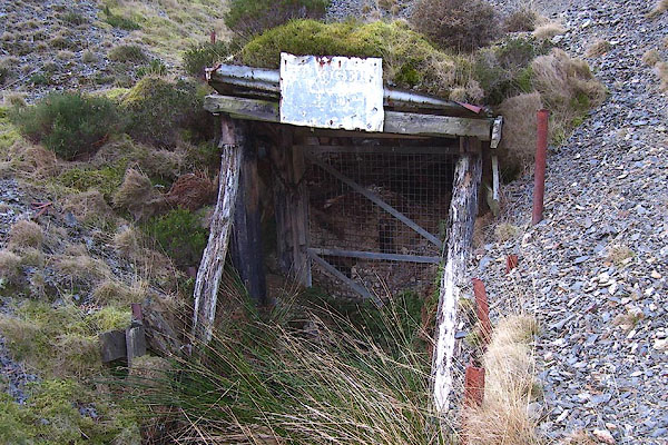 BOR88.jpg (taken 13.2.2008) 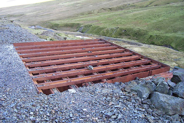 BOR89.jpg (taken 13.2.2008) 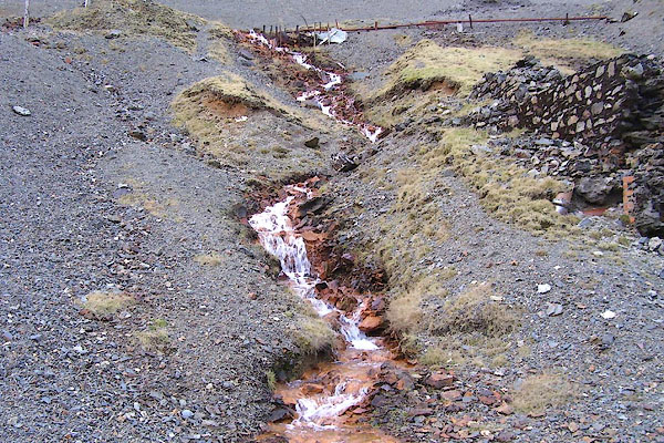 BOR90.jpg (taken 13.2.2008) |
||
|
|
||
 BPI52.jpg copyright images courtesy of Stuart Holme. 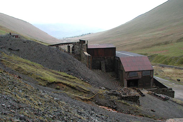 BPI53.jpg copyright images courtesy of Stuart Holme. 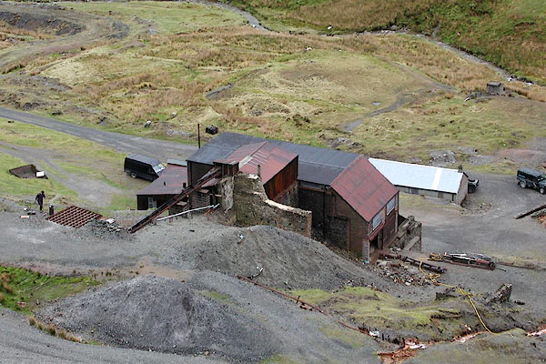 BPI59.jpg copyright images courtesy of Stuart Holme. 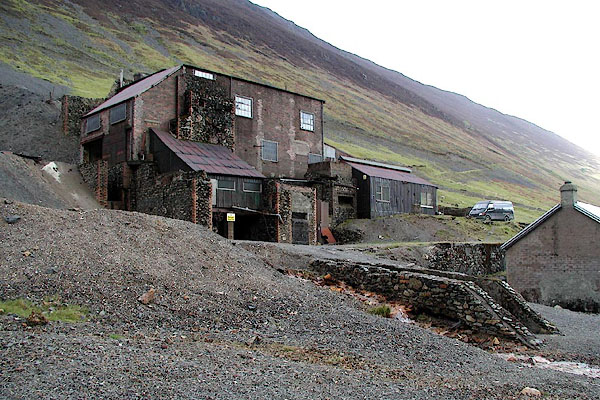 BPI58.jpg copyright images courtesy of Stuart Holme. 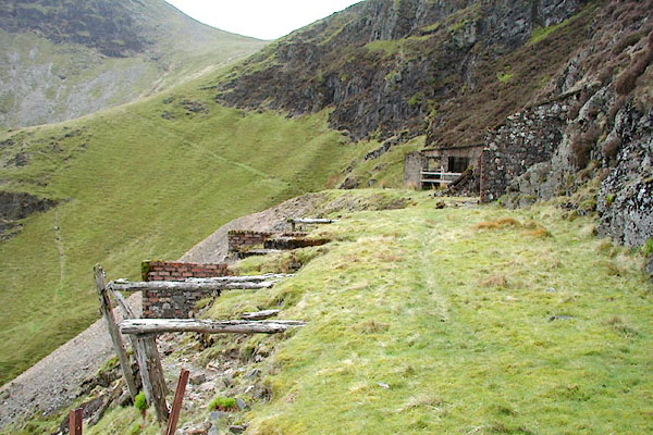 BPI61.jpg copyright images courtesy of Stuart Holme. 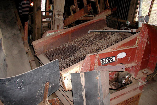 BPI54.jpg copyright images courtesy of Stuart Holme. 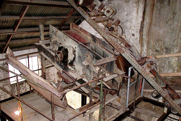 BPI55.jpg copyright images courtesy of Stuart Holme. 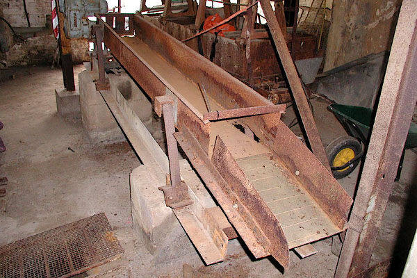 BPI56.jpg copyright images courtesy of Stuart Holme. 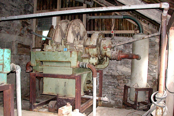 BPI57.jpg copyright images courtesy of Stuart Holme. 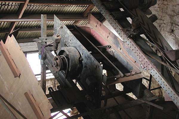 BPI63.jpg copyright images courtesy of Stuart Holme. 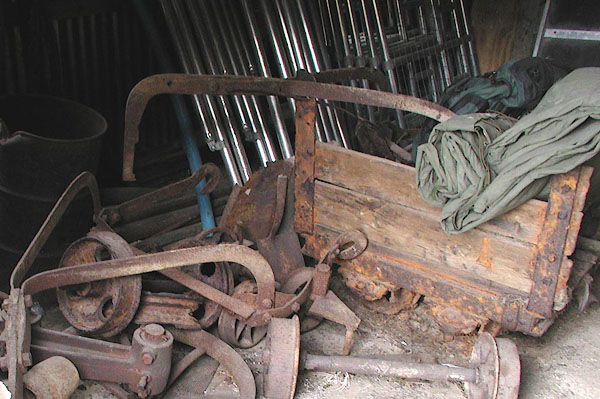 BPI60.jpg copyright images courtesy of Stuart Holme. 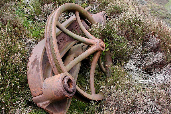 BPI62.jpg copyright images courtesy of Stuart Holme. |
||
|
|
||
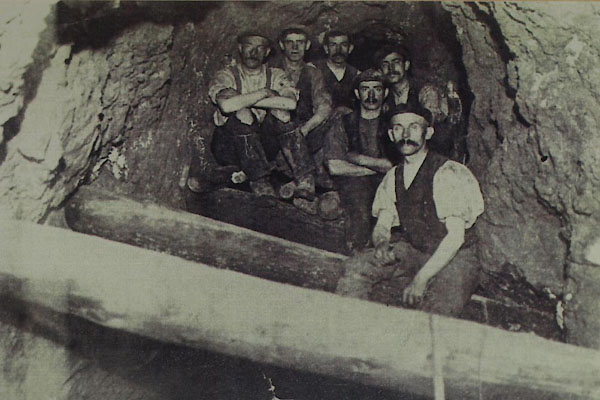 BXQ76.jpg About 1916. (taken 16.11.2012) courtesy of the Royal Oak, Braithwaite 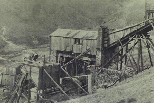 BXQ77.jpg About 1916. (taken 16.11.2012) courtesy of the Royal Oak, Braithwaite 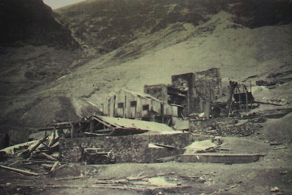 BXQ78.jpg About 1916. (taken 16.11.2012) courtesy of the Royal Oak, Braithwaite |
||
|
|
||
| :- |
An ore analysis report was made in 1578, but whether it was worked then is not known;
there has been a mill on the site since 1840; the mine operated up to the mid 1980s. |
|
| Two workings, High Force Workings and Low Force Workings, exploit the Force Crag Vein:
barytes, barium sulphate, BaSO4; sphalerite, zinc blende, ZnS; and galena, lead sulphide,
PbS - the last bearing silver. |
||
| : 2015 (?): Mines in Cumbria: Cumbria RIGS Adams, John: 1988: Mines of the Lake District Fells: Dalesman Books (Lancaster, Lancashire):: ISBN 0 85206 931 6 |
||
|
|
||
Lakes Guides menu.