 Old Cumbria Gazetteer
 |
 |
|
| Fleetwith, Buttermere | ||
| Fleetwith | ||
| civil parish:- | Buttermere (formerly Cumberland) | |
| county:- | Cumbria | |
| coordinates:- | NY215133 | |
| 1Km square:- | NY2113 | |
| 10Km square:- | NY21 | |
|
|
||
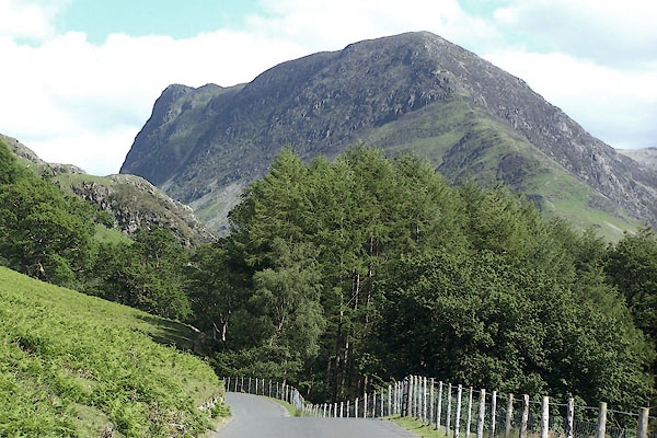 BJQ20.jpg From near Buttermere. (taken 10.6.2005)  Click to enlarge BZG44.jpg (taken 6.9.2013) |
||
|
|
||
| evidence:- | old text:- Gents Mag placename:- Unnesterre placename:- Finisterre |
|
| source data:- | Magazine, The Gentleman's Magazine or Monthly Intelligencer or
Historical Chronicle, published by Edward Cave under the
pseudonym Sylvanus Urban, and by other publishers, London,
monthly from 1731 to 1922. goto source goto sourceGentleman's Magazine 1751 p.53 "..." "The whole mountain is called Unnisterre, or, as I suppose, Finisterre, for such it appears to be; myself and only one more of our company determined to climb this second precipice, and in about another hour we gained the summit: The scene was terrifying, not an herb was to be seen, but wild savine, growing in the interstices of the naked rocks; the horrid projection of vast promontories; the vicinity of the clouds, the thunder of the explosions in the slate quarries, the dreadful solitude, the distance of the plain below, and the mountains heaped on mountains that were piled around us, desolate, and waste, like the ruins of a world which we only had survived, excited such ideas of horror as are not to be expressed. We turned from this fearful prospect afraid even of ourselves, and bidding an everlasting farewel to so perilous an elevation, we descended to our companions, repassed the mines, got to Seathwayte, were chearfully regaled by an honest farmer in his puris naturalibus, returned to Keswic about 9 at night, and got home by 11." "..." |
|
|
|
||
| evidence:- | old map:- Gents Mag 1751 placename:- Unnister Mountain |
|
| source data:- | Map, uncoloured engraving, Map of the Black Lead Mines in
Cumberland, and area, scale about 2 miles to 1 inch, by George
Smith, published in the Gentleman's Magazine, 1751.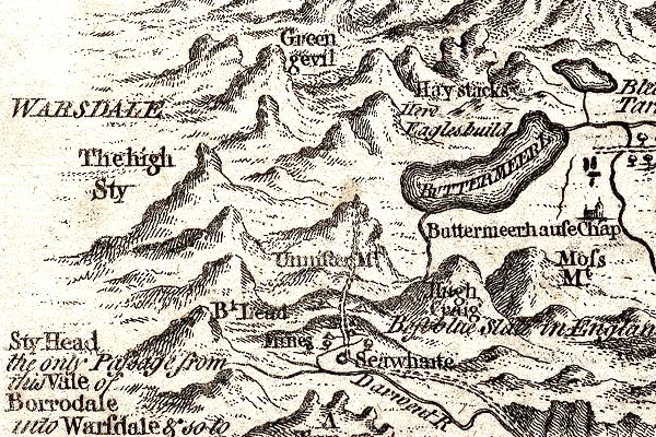 GM1305.jpg "Unnis[ter] Mt" knobbly hillocks; mountains item:- JandMN : 114 Image © see bottom of page |
|
|
|
||
| evidence:- | old map:- Donald 1774 (Cmd) placename:- Honistar Crag |
|
| source data:- | Map, hand coloured engraving, 3x2 sheets, The County of Cumberland, scale about 1
inch to 1 mile, by Thomas Donald, engraved and published by Joseph Hodskinson, 29
Arundel Street, Strand, London, 1774.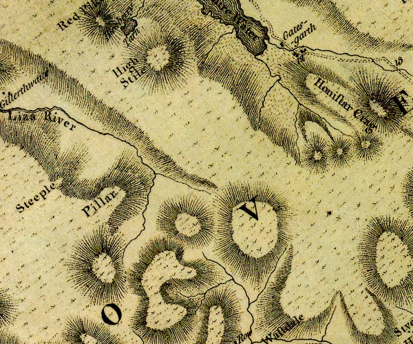 D4NY11SE.jpg "Honistar Crag" hill hachuring; a hill or mountain item:- Carlisle Library : Map 2 Image © Carlisle Library |
|
|
|
||
| evidence:- | old print:- Green 1814 (plate 39) |
|
| source data:- | Print, uncoloured soft ground etching, Crummock Water and Buttermere, Buttermere,
Cumberland, by William Green, Ambleside, Westmorland, 1814.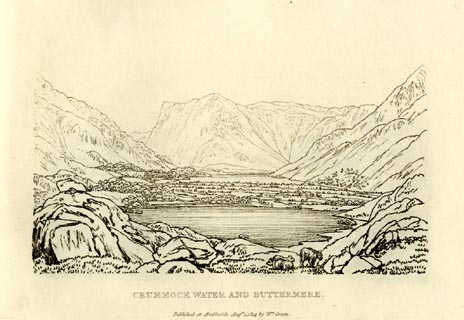 click to enlarge click to enlargeGN0939.jpg Plate 39 in Sixty Small Prints. printed at top right:- "39" printed at bottom:- "CRUMMOCK WATER AND BUTTERMERE. / Published at Ambleside Augst. 1, 1814, by Wm. Green." item:- Armitt Library : A6656.39 Image © see bottom of page |
|
|
|
||
| evidence:- | old print:- Green 1814 (plate 39) |
|
| source data:- | Print, tinted soft ground etching, Crummock Water and Buttermere, Buttermere, Cumberland,
by William Green, Ambleside, Westmorland, 1814.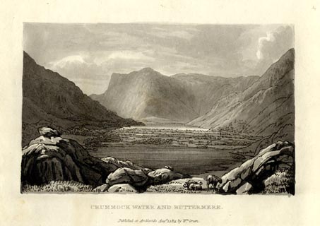 click to enlarge click to enlargeGN1039.jpg Plate 39 in Sixty Small Prints. printed at top right:- "39" printed at bottom:- "CRUMMOCK WATER AND BUTTERMERE. / Published at Ambleside Augst. 1, 1814, by Wm. Green." item:- Armitt Library : A6653.39 Image © see bottom of page |
|
|
|
||
| evidence:- | outline view:- Otley 1823 (4th edn 1830) placename:- Fleetworth |
|
| source data:- | Print, engraving, outline view, The Mountains of Crummock and Buttermere as seen on
the Road between Scale-Hill and Loweswater, published by Jonathan Otley, Keswick,
Cumberland et al, 1830.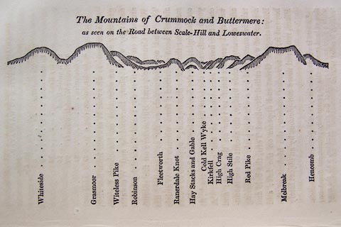 click to enlarge click to enlargeO75E07.jpg p.125 in A Concise Description of the English Lakes, by Jonathan Otley, 4th edition, 1830. "The Mountains of Crummock and Buttermere: / as seen on the Road between Scale-Hill and Loweswater." "Whiteside / Grasmoor / Witeless Pike / Robinson / Fleetworth / Rannerdale Knot / Hay Stacks and Gable / Cold Kell Wyke / Kirkfell / High Crag / High Stile / Red Pike / Melbreak / Hencomb" item:- Armitt Library : A1175.7 Image © see bottom of page |
|
|
|
||
| evidence:- | old print:- Westall 1830s |
|
| source data:- | Print, aquatint panorama, Buttermere Lake, from the North Side, Cumberland, drawn
and engraved by William Westall, published by Ackermann and Co, 96 Strand, London,
1839.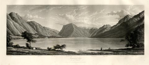 click to enlarge click to enlargeWTL317.jpg "Drawn & Engraved by W. Westall A.R.A. / Hassness. Yew Crag. Honister Crag. Great Gavel. Haystacks. Highstile. Chapel Crag. / Buttermere Lake, from the North side. / London. Published by Ackermann and Co, 96 Strand. 1839." item:- Armitt Library : A6658.17 Image © see bottom of page |
|
|
|
||
| evidence:- | old photograph:- Bell 1880s-1940s item:- gate |
|
| source data:- | Photograph, black and white, looking towards Fleetwith, Buttermere, Cumberland, by
Herbert Bell, photographer, Ambleside, Westmorland, 1890s.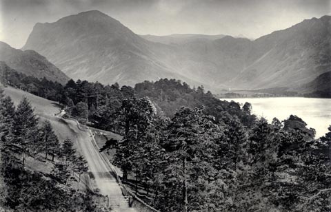 click to enlarge click to enlargeHB0877.jpg Notice the gate across the road. item:- Armitt Library : ALPS548 Image © see bottom of page |
|
|
|
||
| evidence:- | old photograph:- Bell 1880s-1940s |
|
| source data:- | Photograph, black and white, Fleetwith and Honister Crag, and Buttermere lake, Buttermere,
Cumberland, by Herbert Bell, Ambleside, Westmorland, 1890s.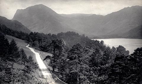 click to enlarge click to enlargeHB0425.jpg internegative at lower left:- "H. Bell" stamped at reverse:- "HERBERT BELL / Photographer / AMBLESIDE" item:- Armitt Library : ALPS79 Image © see bottom of page |
|
|
|
||
| notes:- |
Nancy Price:- |
|
| "... looking like a great beast that has just crawled up from the lake." |
||
| Baron 1925 |
||
|
|
||
Lakes Guides menu.