 Old Cumbria Gazetteer
 |
 |
|
| Flat Stone Pot, North Yorkshire | ||
| Flat Stone Pot | ||
| Flatstones Pot | ||
| county:- | North Yorkshire | |
| locality type:- | pothole | |
| locality type:- | cave | |
| coordinates:- | SD713770 | |
| 1Km square:- | SD7177 | |
| 10Km square:- | SD77 | |
| altitude:- | 1300 feet | |
| altitude:- | 396m | |
| SummaryText:- | Grade II. | |
| references:- | Balderston c1890 Brook, D & Davies, G & Long, M H &Sutcliffe, J R: 1975: Northern Caves, vol.4 Whernside and Gragareth: Dalesman Books:: ISBN 0 85206 259 1 |
|
|
|
||
| evidence:- | descriptive text:- Balderston c1890 placename:- Flat Stone Pot placename:- Scales Moor Pot |
|
| source data:- | Book, Ingleton, Bygone and Present, by Robert R and Margaret
Balderston, published by Simpkin, Marshall and Co, London, and
by Edmndson and Co, 24 High Street, Skipton, Yorkshire, about
1890. goto source goto sourcepage 79:- "..." "Flat Stone, or Scales Moor Pot." "Crossing over the low spur of Whernside towards the scars on the eastern side, and about a mile or more from Twisleton Hall, close under the slope of the spur dividing the moorland and limestone plateau, a couple of holes may be seen, neither apparently of great depth; but on close examination the southern end of the north-eastern pot, discloses a deep shaft, thirty-thee feet to the first stopping point - to which we, in fact, descended. A sound of water, like that of a strong stream or waterfall can be heard within, and the total depth ascertained by line was fifty-one feet. A flat stone rests over the deepest portion of the fissure. A few mountain ash and ferns are to be seen above." |
|
|
|
||
| evidence:- | old map:- Balderston c1890 map placename:- Flatstone Pot |
|
| source data:- | Map, the hills in the Ingleton area, probably by Robert R
Balderston, engraved by Goodall and Suddick, Leeds, West
Yorkshire, about 1890.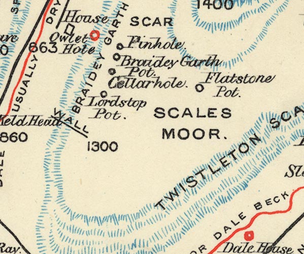 BS1SD77D.jpg "Flatstone Pot" item:- private collection : 27.1 Image © see bottom of page |
|
|
|
||
Lakes Guides menu.