 Old Cumbria Gazetteer
 |
 |
|
| Finsthwaite Heights, Colton | ||
| Finsthwaite Heights | ||
| civil parish:- | Colton (formerly Lancashire) | |
| county:- | Cumbria | |
| locality type:- | hill | |
| coordinates:- | SD361881 (etc) | |
| 1Km square:- | SD3688 | |
| 10Km square:- | SD38 | |
|
|
||
| evidence:- | old map:- OS County Series (Lan 8 10) placename:- Finsthwaite Heights |
|
| source data:- | Maps, County Series maps of Great Britain, scales 6 and 25
inches to 1 mile, published by the Ordnance Survey, Southampton,
Hampshire, from about 1863 to 1948. |
|
|
|
||
| evidence:- | old drawing:- Aspland 1840s-60s placename:- Finsthwaite Heights |
|
| source data:- | Drawing, pencil, Finsthwaite Summer House Tower, Colton, Lancashire, by Theophilus
Lindsey Aspland, 25 May 1870.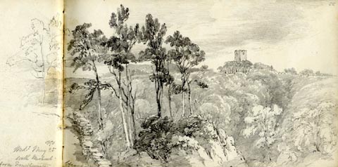 click to enlarge click to enlargeAS0666.jpg "1870 / Wedy. May 25 / with Michael / Tower Newby Br from Finsthwaite Heights" page number "55" item:- Armitt Library : 2008.61.66 Image © see bottom of page |
|
|
|
||
 Lakes Guides menu.