 Old Cumbria Gazetteer
 |
 |
|
| Ennerdale Fell, Ennerdale and Kinniside | ||
| Ennerdale Fell | ||
| civil parish:- | Ennerdale and Kinniside (formerly Cumberland) | |
| county:- | Cumbria | |
| locality type:- | hill | |
| locality type:- | fell | |
| coordinates:- | NY13341281 (etc) | |
| 1Km square:- | NY1312 | |
| 10Km square:- | NY11 | |
|
|
||
| evidence:- | old map:- OS County Series (Cmd 69 13) placename:- Ennerdale Fell |
|
| source data:- | Maps, County Series maps of Great Britain, scales 6 and 25
inches to 1 mile, published by the Ordnance Survey, Southampton,
Hampshire, from about 1863 to 1948. OS County Series (Cmd 69 14) |
|
|
|
||
| evidence:- | old print:- Pyne 1853 |
|
| source data:- | Drawn by James Barker Pyne, 1848-1853, lithographed by T Picken, 1859.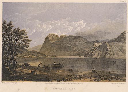 click to enlarge click to enlargePY16.jpg "Ennerdale Lake" item:- JandMN : 97.15 Image © see bottom of page |
|
|
|
||
 Lakes Guides menu.