 Old Cumbria Gazetteer
 |
 |
|
||
| Doe, River | ||||
| county:- | North Yorkshire | |||
| locality type:- | river | |||
| coordinates:- | SD694732 (etc) | |||
| 1Km square:- | SD6973 | |||
| 10Km square:- | SD67 | |||
|
|
||||
| evidence:- | old map:- Saxton 1579 |
|||
| source data:- | Map, hand coloured engraving, Westmorlandiae et Cumberlandiae Comitatus ie Westmorland
and Cumberland, scale about 5 miles to 1 inch, by Christopher Saxton, London, engraved
by Augustinus Ryther, 1576, published 1579-1645.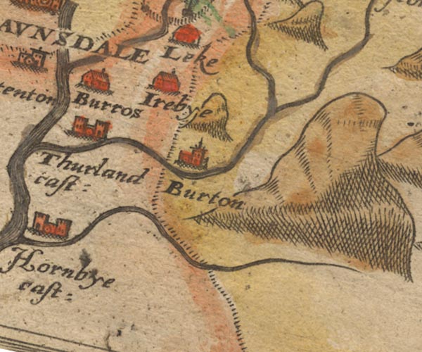 Sax9SD67.jpg item:- private collection : 2 Image © see bottom of page |
|||
|
|
||||
| evidence:- | old map:- Speed 1611 (Wmd) |
|||
| source data:- | Map, hand coloured engraving, The Countie Westmorland and
Kendale the Cheif Towne, scale about 2.5 miles to 1 inch, by
John Speed, 1610, published by George Humble, Popes Head Alley,
London, 1611-12.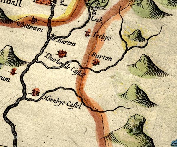 SP14SD67.jpg double line, into the Greta item:- Armitt Library : 2008.14.5 Image © see bottom of page |
|||
|
|
||||
| evidence:- | old map:- Seller 1694 (Wmd) |
|||
| source data:- | Map, hand coloured engraving, Westmorland, scale about 8 miles
to 1 inch, by John Seller, 1694. click to enlarge click to enlargeSEL7.jpg tapering wiggly line; river item:- Dove Cottage : 2007.38.87 Image © see bottom of page |
|||
|
|
||||
| evidence:- | old map:- Simpson 1746 map (Wmd) placename:- Gete River |
|||
| source data:- | Map, uncoloured engraving, Westmorland, scale about 8 miles to 1
inch, printed by R Walker, Fleet Lane, London, 1746. SMP2SDT.jpg Wiggly line; through Ingleton. item:- Dove Cottage : 2007.38.59 Image © see bottom of page |
|||
|
|
||||
| evidence:- | descriptive text:- West 1778 (3rd edn 1784) |
|||
| source data:- | Guide book, A Guide to the Lakes, by Thomas West, published by
William Pennington, Kendal, Cumbria once Westmorland, and in
London, 1778 to 1821. goto source goto source3rd edn addenda, page 231:- "[in Weathercoate Cave] ... [two cascades] fall together into a narrow pool at the bottom, which measures 37 yards in depth; and proceeding underground about a mile, break out, and form the large brook that runs by Ingleton, and from thence to the river Lune. In the time of great rains, the subterraneous channel that conveys away the water becomes too small, and then the cavern fills to a depth of above 100 yards, and runs over at the surface. ..." |
|||
|
|
||||
| evidence:- | descriptive text:- West 1778 (11th edn 1821) placename:- Wease, River placename:- Greta, River placename:- Greatah, River |
|||
| source data:- | Guide book, A Guide to the Lakes, by Thomas West, published by
William Pennington, Kendal, Cumbria once Westmorland, and in
London, 1778 to 1821. goto source Tour to the Caves in the West Riding of Yorkshire, late 18th century Page 251:- "..." "After we had regaled and rested ourselves comfortably at the Bay-horse, we took an evening walk, about a mile above the town [Ingleton], to the slate quarries by the side of the river Wease, or Greta, which comes down out of Chapel-in-the-Dale, and joins the Kingsdale river at Ingleton. ..." goto sourcePage 252:- "... [at the slate quarry] the river rolling down from rock to rock, in a narrow deep chasm, where there was no room for human foot to tread between the stream and the rugged, high, steep rocks on each side. ..." "Ingleton is a pretty village, pleasantly situated on a natural mount, yet at the bottom of a vale, near the conflux of two" goto sourcePage 253:- "rivers, over which are thrown two handsome arches. If the streams are sometimes small, the huge stones and fragments of rocks which are rolled down the beds of these rivers, will serve to show that at other times they are remarkably full and impetuous. ..." goto sourcePage 254:- "... About three miles from Ingleton is the head of the river Wease, or Greta, on the left hand side of the road, only a few yards distant from it. It gushes out of several fountains at once, all within twenty or thirty yards of each other; having run about two miles under ground, though making its appearance in two or three places within that distance. When there are floods, its runs also above ground, though not in all places, except the rains are extraordinary great. This the subterranean river mentioned by Dr. Goldsmith in his entertaining Natural history, (vol. 1st,) by the name of Greatah." goto sourcePage 257:- "..." "When we arrived in the superior regions [from Hurtlepot], we pursued our journey about a hundred and fifty yards farther up a very narrow grotesque glen, over a natural bridge of limestone above ten yards thick, having the subterranean river Wease, or Greta, underneath. When we got to the head of this gill, we were stopped by a deep chasm called Ginglepot, at the bottom of a precipice. ..." goto sourcePage 267:- "... we arrived at ... Gatekirk-Cave. [1] The brook that runs through it forms a fine natural bason of transparent water at its egress, where we entered the cave, ..." "[1] A furlong or two before we arrived at Gatekirk, we paased (sic) a little cascade, amongst some hollow limestone rocks, which would be a fine embellishment to a gentleman's garden or park. All the ground about seemed hollow, and we saw various chasms and empty spaces between the strata of rocks, though none worth a particular description in a country abounding with such a variety of a superior nature." goto sourcePage 269:- "... The brook which runs through this cave is the main stream of the river Greta, which runs under ground for at last two miles, making its appearance here, at Weathercoat, and a few other places in its way down to its open channel. The pools that are formed by the brook after its exit out of the cave, exhibit a pleasing and rural scene, being shaded with rocks, weeping willows, and mountain ash." |
|||
|
|
||||
| evidence:- | descriptive text:- Balderston c1890 placename:- |
|||
| source data:- | Book, Ingleton, Bygone and Present, by Robert R and Margaret
Balderston, published by Simpkin, Marshall and Co, London, and
by Edmndson and Co, 24 High Street, Skipton, Yorkshire, about
1890. goto source page 34:- "WEATHERCOTE Cave, in the valley of the Doe, and four miles from Ingleton, is a wonderful spot. As a mere cave it is, perhaps, not of much note, but as a stupendous chasm into which a magnificent spout of water descends to a great depth, ..." goto sourcepage 35:- "... The rock immediately opposite is one hundred and eight feet high; thirty-one feet below is a gap in the corner of the rocks, whence a spout of water rushes with great force from behind a huge mass of rock, wedged in between the opposite cliffs, and then, descending from higher recesses of the upper cavern for ten feet, is precipitated to a further depth of sixty-five ere crashing into the small but turbulent basin beneath. When the sun is shining at mid-day in summer, a splendid rainbow arch spans the ascending spray, ... After unusually heavy rains various cascades pour over the edges of the rocks, and through a rift, into the abyss or whirlpool-hole below, for then the cave becomes half filled with water, and occasionally the river, descending the dry watercourse to the north-east - the course for the top water in heavy floods - pours as a muddy torrent over the verge of the flanking rock, filling the cavern to the brim with its liquid superfluity, and overflowing through the gaps in the wall forming the southern boundary. ..." goto sourcepage 37:- "..." "Some distance above Weathercote is Gatekirk Cave, the subterranean passage of the Doe in its upper section; ..." goto sourcepage 38:- "... the Doe, although here so far up the mountains, quits its subterranean tenement as a by no means insignificant stream, and has its course broken by a series of foaming but puny falls, darkened by overhanging underwood, until it is once more embowelled in other inaccessible passages a little further down the dale. ..." |
|||
|
|
||||
| evidence:- | old map:- Balderston c1890 map placename:- Doe Beck placename:- Dale Beck |
|||
| source data:- | Map, the hills in the Ingleton area, probably by Robert R
Balderston, engraved by Goodall and Suddick, Leeds, West
Yorkshire, about 1890.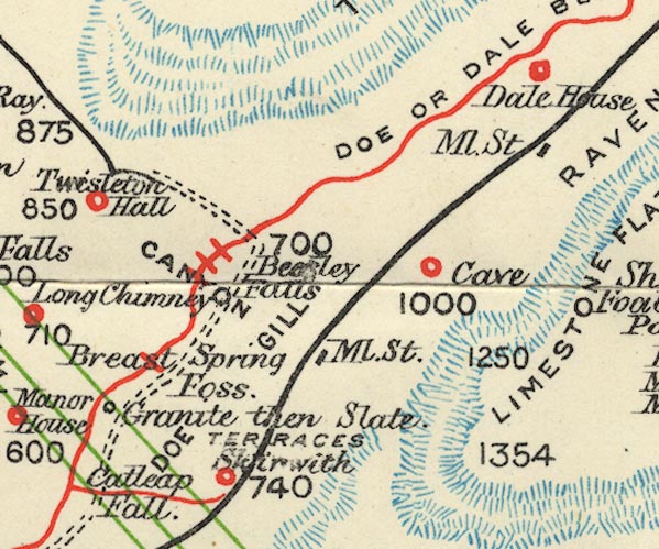 BS1SD77C.jpg "DOE OR DALE BECK" item:- private collection : 27.1 Image © see bottom of page |
|||
|
|
||||
| places:- |
|
|||
Lakes Guides menu.