 Old Cumbria Gazetteer
 |
 |
|
| Dodd, Underskiddaw | ||
| Dodd | ||
| civil parish:- | Underskiddaw (formerly Cumberland) | |
| county:- | Cumbria | |
| locality type:- | hill | |
| coordinates:- | NY24422735 (etc) | |
| 1Km square:- | NY2427 | |
| 10Km square:- | NY22 | |
| altitude:- | 1612 feet | |
| altitude:- | 491m | |
|
|
||
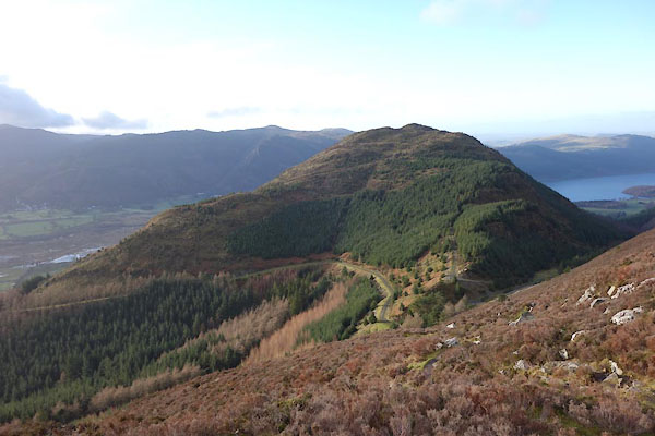 BZT61.jpg (taken 28.12.2013) 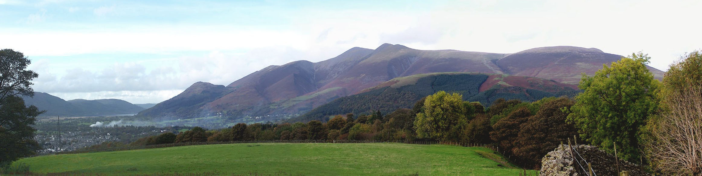 Click to enlarge BMX41.jpg Keswick, Dodd, Skiddaw, Lonscale Fell, Blease Fell and Latrigg, viewed from the south. (taken 23.10.2006) |
||
|
|
||
| evidence:- | old map:- OS County Series (Cmd 56 9) placename:- Dodd |
|
| source data:- | Maps, County Series maps of Great Britain, scales 6 and 25
inches to 1 mile, published by the Ordnance Survey, Southampton,
Hampshire, from about 1863 to 1948. |
|
|
|
||
| evidence:- | outline view:- Otley 1823 (4th edn 1830) placename:- Dod, The |
|
| source data:- | Print, engraving, Outline View of Skiddaw, and Saddleback, as seen on approaching
Keswick from the South, published by Jonathan Otley, Keswick, Cumberland et al, 1830.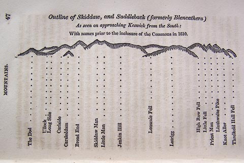 click to enlarge click to enlargeO75E01.jpg p.47 in A Concise Description of the English Lakes, by Jonathan Otley, 4th edition, 1830. "Outline View of Skiddaw, and Saddleback (formerly Blencathera) As seen on approaching Keswick from the South: With names prior to the inclosure of the Commons in 1810." "The Dod / Ullock / Long Side / Carleside / Carsleddam / Broad End / Skiddaw Man / Little Man / Jenkin Hill / Lonscale Fell / Latrigg / High Row Fell / Little Fell / Priest Man / Linthwaite Pike / Knot Aller / Threlkeld Hall Fell" item:- Armitt Library : A1175.2 Image © see bottom of page |
|
|
|
||
| evidence:- | outline view:- Otley 1823 (8th edn 1849) placename:- Dod, The |
|
| source data:- | Engraving, outline view of mountains, Skiddaw, and Saddleback ... as seen on entering
Keswick from the South, drawn by T Binns, engraved by O Jewitt, opposite p.46 of A
Descriptive Guide of the English Lakes, by Jonathan Otley, 8th edition, 1849.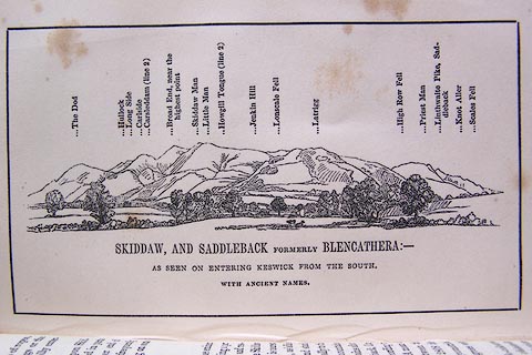 click to enlarge click to enlargeO80E16.jpg item:- Armitt Library : A1180.17 Image © see bottom of page |
|
|
|
||
| evidence:- | outline view:- Otley 1823 (5th edn 1834) placename:- Dod, The |
|
| source data:- | Print, woodcut outline view, Skiddaw and Saddleback, by Jonathan Otley, Keswick, Cumberland,
1830.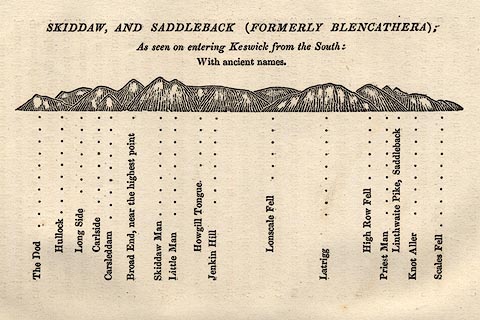 click to enlarge click to enlargeOT2E08.jpg Printed on p.49 of A Concise Description of the English Lakes, by Jonathan Otley, 5th edition, 1834. "SKIDDAW, AND SADDLEBACK (FORMERLY BLENCATHRA): As seen entering Keswick from the South: With ancient names." "The Dod / Hullock / Long Side / Carlside / Carsleddam / Broad End, near the highest point / Skiddaw Man / Little Man / Howgill Tongue / Jenkin Hill / Lonscale Fell / Latrigg / High Row Fell / Priest Man / Linthwaite Pike, Saddleback / Knot Aller / Scales Fell" item:- JandMN : 48.9 Image © see bottom of page |
|
|
|
||
| evidence:- | old print:- Westall 1830s placename:- Skiddaw Dod |
|
| source data:- | Print, aquatint panorama, Bassenthwaite Lake, from the Keswick Road, near the 6 Mile
Stone, Cumberland, drawn and engraved by William Westall, published by Ackermann and
Co, 96 Strand, London, 1835.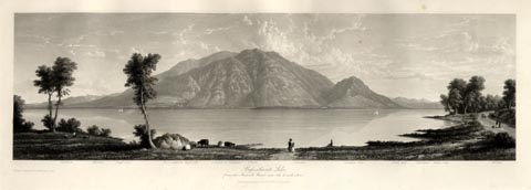 click to enlarge click to enlargeWTL316.jpg "Caldbeck. Westfell. Dead crags. Bassenthwaite high side. Summit of Skiddaw. Ullock. Carlside. Skiddaw dod. Great dod. Helvellen. Walla crag. Catbell. / Drawn & Engraved by W. Westall A.R.A. / Bassenthwaite Lake, from the Keswick Road, near the 6 mile stone. / Published by Ackermann and Co, 96 Strand. 1835." item:- Armitt Library : A6658.16 Image © see bottom of page |
|
|
|
||
| evidence:- | probably old map:- Garnett 1850s-60s H placename:- Dod Fell |
|
| source data:- | Map of the English Lakes, in Cumberland, Westmorland and
Lancashire, scale about 3.5 miles to 1 inch, published by John
Garnett, Windermere, Westmorland, 1850s-60s. GAR2NY22.jpg "Dod Fell" hill hachuring item:- JandMN : 82.1 Image © see bottom of page |
|
|
|
||
| evidence:- | outline view:- Matthew 1866 placename:- Dodd, The |
|
| source data:- | Print, engraving, outline view, View from Watendlath Road of Derwent Water and Bassenthwaite,
Cumberland, published by J Richardson, Highgate, Kendal, Westmorland, 1866.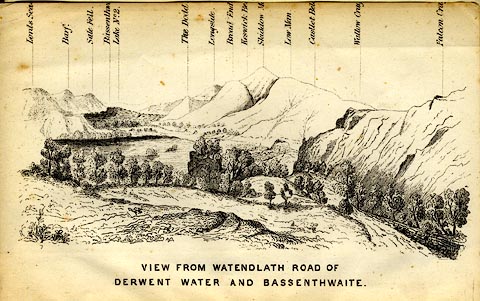 click to enlarge click to enlargeMW1E05.jpg Tipped in before p.1 of The English Lakes, Peaks and Passes, from Kendal to Keswick, by George King Matthew. printed at bottom:- "VIEW FROM WATENDLATH ROAD OF / DERWENT WATER AND BASSENTHWAITE." printed at caption to mountains:- "... The Dodd ..." item:- Armitt Library : A1168.5 Image © see bottom of page |
|
|
|
||
| evidence:- | outline view:- Black 1856 (23rd edn 1900) placename:- Dod |
|
| source data:- | Print, lithograph, Outline Views, Skiddaw and Derwent Water - Mountains as seen at
Lodore Hotel, and Mountains as seen at the Third Gate on Ascending Latrigg on the
Way to Skiddaw, by J Flintoft, Keswick, Cumberland, engraved by R Mason, Edinburgh,
Lothian, about 1900.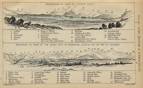 click to enlarge click to enlargeBC08E4.jpg "... 5 Dod ..." item:- JandMN : 37.14 Image © see bottom of page |
|
|
|
||
| evidence:- | outline view:- Black 1841 (3rd edn 1846) placename:- Dod |
|
| source data:- | Print, engraving, outline view, Mountains as seen at Lowdore Inn, and Mountains as
seen at the Third Gate on Ascending Latrigg on the Way to Skiddaw, by J Flintoft,
Keswick, Cumberland, engraved by R Mason, Edinburgh, Lothian, about 1846.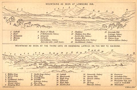 click to enlarge click to enlargeBC02E4.jpg "... 5 Dod ..." item:- JandMN : 32.7 Image © see bottom of page |
|
|
|
||
| hearsay:- |
On the side of Dodd, on a ledge above Scalebeck Gill, above Dancing gate, a hermit,
George Smith, made his home of sticks and stones, with a bed of leaves. He was born
in Banffshire about 1825; is said to have worn no shoes, or coat, or hat, and to have
had a single shirt; was partial to a dram and was sometimes arrested, drunk. He sold
portraits to visitors who managed to find him. His lair was destroyed by 19th century
hooligans, and he went to live in Keswick. George Smith suffered from religious mania,
was removed to an asylum in Banfshire, where he died 1875. |
|
|
|
||
 Lakes Guides menu.